Toggle navigation
LMEC Home
Exhibitions
Georeferencing
Tools for Teachers
Collections
My Favorites
Sign Up / Log In
Search
Search the map portal
Map Collection
Map Collection
Map Sets
Search
Search
Search for
Search In
All Fields
Creator
Title
Subject
Place
Search All Digital Collections
Advanced Search
13385 Results
Filter your Search
Place
North and Central America
9,353
United States
7,286
Suffolk (county)
1,664
Boston
1,621
Europe
1,035
Canada
949
Massachusetts
875
New York
534
more
Place
»
Topic
Boston (Mass.)--Maps
741
City planning--Massachusetts--Boston--Maps
418
United States--History--Revolution, 1775-1783--Maps
329
United States--Maps
315
Urban renewal--Massachusetts--Boston--Maps
254
Real property--Massachusetts--Boston--Maps
252
Massachusetts--Maps
219
Insurance surveys
197
more
Topic
»
Date
Date range begin
–
Date range end
Current results range from
1482
to
2023
View distribution
Creator
United States. Hydrographic Office
595
Boston Redevelopment Authority
403
Des Barres, Joseph F. W. (Joseph Frederick Wallet), 1722-1824
247
Royal United Services Institute for Defence and Security Studies
160
Jefferys, Thomas, -1771
154
George, III, King of Great Britain, 1738-1820
152
George, IV, King of Great Britain, 1762-1830
151
O.H. Bailey & Co
148
more
Creator
»
Format
Maps/Atlases
13,205
Manuscripts
985
Prints
102
Books
49
Drawings/Illustrations
44
Photographs
15
Objects/Artifacts
13
Documents
7
more
Format
»
Georeferenced
Yes
979
No
12,406
Collection
Norman B. Leventhal Map Center Collection
8,891
American Revolutionary War-Era Maps
3,305
Boston and New England Maps
2,804
Urban Maps
2,397
Maritime Charts and Atlases
1,150
William L. Clements Library Collection
910
Library of Congress Collection
618
Boston Redevelopment Authority Collection
475
more
Collection
»
Available to use
No known restrictions
9,952
Creative Commons license
1,677
Search Constraints
Sort by date (asc)
relevance
title
date (asc)
date (desc)
Number of results to display per page
50 per page
10
per page
20
per page
50
per page
100
per page
View results as:
grid view
map view
Search Results
13151.
Charlestown Veterans Memorial, Charlestown, Massachusetts
13152.
Chesapeake Bay, environmentally sensitive areas
13153.
DEP water supply contamination correction program underground storage tank locations compared to natural resource data : Auburn...
13154.
General and zoning map for town of Wakefield Mass.
13155.
Landscaping plan of City Hall Plaza, Boston
13156.
Landuse change on Cape Cod 1971-1984
13157.
Massachusetts Bay Transportation Authority system map
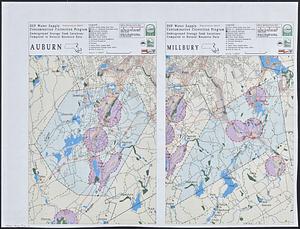
13158.
Massachusetts river basins
13159.
The nuclear weapons complex transportation routes
13160.
Shawmut Avenue
13161.
Cultural facilities conceptual plan
13162.
Midtown area plan for the public realm
13163.
South End urban renewal area project Mass. r-56 site preparation contract no. 50 Worcester Square Park reconstruction
13164.
New Congress Street improvements
13165.
Architectural styles, Chinatown historic core, historic edge
13166.
General plan of the MWRA/MDC water system
13167.
James Hayes Park
13168.
John Hancock office and parking garage complex, Boston, Massachusetts
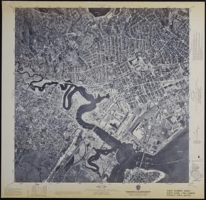
13169.
Mass pike air rights study
13170.
Massachusetts shoreline change summary map
13171.
We must have order
13172.
Zoning districts, city of Boston
13173.
Hancock Woods : as of right plan
13174.
660 Wakulah St., Roxbury
13175.
Ruggles Center : existing condition plan
13176.
Ruggles Center : site area diagram
13177.
FPIR/FEIR Olmsted Plaza : a redevelopment of the Sears property, 309 Park Drive/201 Brookline Avenue in the Fenway
13178.
Sears Park conceptual site plan with historic waterway
13179.
Boston's bikemap : Arlington, Belmont, Brookline, Cambridge, Chelsea, Everett, Lexington, Malden, Medford, Needham, Newton,...
13180.
Brighton and Allston urban design strategy
13181.
Charlestown Navy Yard master plan
13182.
Columbia Point updated base maps
13183.
EOEA MassGIS geographic information system transition document : The EOEA geographic information system: MassGIS
13184.
Flirtation walk existing conditions plan Charlestown Navy Yard
13185.
Gate 5 - Chelsea Street modified landscape scheme, Charlestown, MA
13186.
Illustrative site plan : a proposal for community review South End/Lower Roxbury development policy
13187.
Illustrative site plan : a proposal for community review South End/Lower Roxbury development policy
13188.
Land use shading test plot shadeset PI and lu21-pi.lut
13189.
Little Mystic Channel landscape scheme, Charlestown, MA
13190.
Map of Greylock center site, Adams, Massachusetts
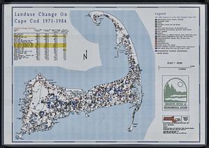
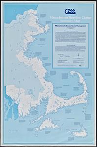
13191.
Massachusetts coastal towns
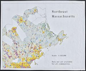
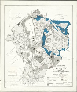
13192.
Northeast Massachusetts
13193.
Open space map of Connecticut, lands dedicated as open space, and selected undeveloped land, lands managed but not dedicated as...
13194.
Orthophoto map of Boston, Lynn Common
13195.
Outline map of Boston
13196.
Profile of Huntington Avenue/St. James Avenue from Harcourt Street to Berkeley Street
13197.
Ropewalk bldg. Charlestown Navy Yard
13198.
Samples of analog and digital orthophotos
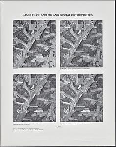
13199.
Shadow analysis
13200.
Street trees Comm. Ave.
‹ Prev
Next ›
1
2
…
260
261
262
263
264
265
266
267
268