General plan of the MWRA/MDC water system

Item Information
- Title:
- General plan of the MWRA/MDC water system
- Title (alt.):
-
Massachusetts Water Resources Authority, water system
- Issuing body:
- Massachusetts Water Resources Authority
- Contributor:
- Massachusetts. Metropolitan District Commission
- Name on Item:
-
Massachusetts Water Resources Authority
- Date:
-
[1989?]
- Format:
-
Maps/Atlases
- Location:
-
Boston Public Library
Norman B. Leventhal Map & Education Center - Collection (local):
-
David Judkins Weaver Papers
- Subjects:
-
Massachusetts--Maps
Waterworks--Massachusetts--Maps
Water-supply--Massachusetts--Maps
Watersheds--Massachusetts--Maps
Hydroelectric power plants--Massachusetts--Maps
Massachusetts Water Resources Authority
- Places:
-
Massachusetts
- Extent:
- 1 map : color ; 27 x 63 cm, on sheet 54 x 63 cm, folded to 18 x 10 cm
- Terms of Use:
-
No known copyright restrictions.
No known restrictions on use.
- Publisher:
-
Boston :
Massachusetts Water Resources Authority
- Scale:
-
Scale approximately 1:280,000
- Language:
-
English
- Notes:
-
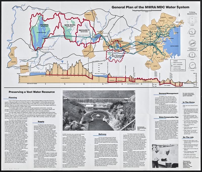
Covers Massachusetts from Connecticut River to Boston region.
Also shows power generating stations.
Includes text, illustrations, cross-sections of typical aqueducts, and longitudinal section of MWRA water system.
Text, maps, and illustrations on verso.
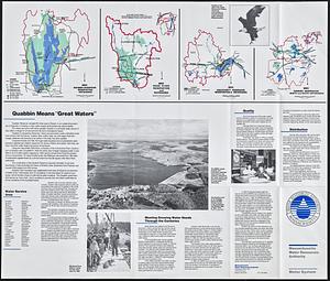
Maps on verso: MDC Quabbin Reservoir Reservation watershed -- MDC Ware River Reservation and watershed -- MDC Wachusett Reservoir Reservation & watershed -- MDC Sudbury Reservation, north and south watersheds.
- Identifier:
-
06_01_018801A
06_01_018801B
- Call #:
-
Weaver folder 15 no. 5


