Ropewalk bldg. Charlestown Navy Yard


Item Information
- Title:
- Ropewalk bldg. Charlestown Navy Yard
- Description:
-
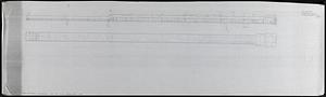
2 annotated versions of a map of the ropewalk building with an illustration of the side of the building from the southeast.
- Publisher:
- Boston Redevelopment Authority
- Cartographer:
- Glassman, Jack
- Name on Item:
-
from Jack Glassman
- Date:
-
1990
- Format:
-
Drawings/Illustrations
- Location:
-
Boston Public Library
Norman B. Leventhal Map & Education Center - Collection (local):
-
Norman B. Leventhal Map & Education Center Collection
- Series:
- Boston Redevelopment Authority Maps & Manuscript Plans Collection
- Subjects:
-
Charlestown (Boston, Mass.)--Maps
Buildings--Massachusetts--Boston--Maps
City planning--Massachusetts--Boston--Maps
Charlestown Navy Yard (Mass.)
- Places:
-
MassachusettsSuffolk (county)BostonCharlestown
- Extent:
- 2 maps ; on sheets 30 x 107 cm and 32 x 107 cm
- Terms of Use:
-
No known copyright restrictions.
No known restrictions on use.
- Publisher:
-
[Boston] :
[Boston Redevelopment Authority]
- Scale:
-
Scale 1:384. 32-scale
- Language:
-
English
- Notes:
-
One version on translucent mylar sheet with notes about the windows and building height.
One version on paper with measurements and notes about sidewalk and overpass.
- Identifier:
-
06_01_017781A
06_01_017781B
- Call #:
-
BRA MAP FOLDER 5
- Barcode:
-
30000007747823


