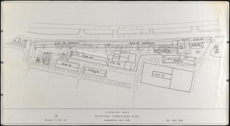
Flirtation walk existing conditions plan Charlestown Navy Yard

Item Information
- Title:
- Flirtation walk existing conditions plan Charlestown Navy Yard
- Cartographer:
- Boston Redevelopment Authority
- Date:
-
1990
- Format:
-
Maps/Atlases
- Genre:
-
Manuscript maps
- Location:
-
Boston Public Library
Norman B. Leventhal Map & Education Center - Collection (local):
-
Norman B. Leventhal Map & Education Center Collection
- Series:
- Boston Redevelopment Authority Maps & Manuscript Plans Collection
- Subjects:
-
Charlestown (Boston, Mass.)--Maps
City planning--Massachusetts--Boston--Maps
Charlestown Navy Yard (Mass.)
- Places:
-
MassachusettsSuffolk (county)BostonCharlestown
- Extent:
- 1 manuscript map and 1 map ; 60 x 126 cm
- Terms of Use:
-
No known copyright restrictions.
No known restrictions on use.
- Publisher:
-
[Boston] :
[Boston Redevelopment Authority]
- Scale:
-
Scale 1:480. Scale 1" = 40'-0"
- Language:
-
English
- Notes:
-
Manuscript map and photocopy of manuscript map.
Shows buildings, manholes, hydrants, lamps, utility trenches, catchbasins, and other features.
Oriented with north to the upper right.
"30 July 1990."
- Identifier:
-
06_01_017875A
06_01_017875B
- Call #:
-
BRA MAP FOLDER 6
- Barcode:
-
30000007747825


