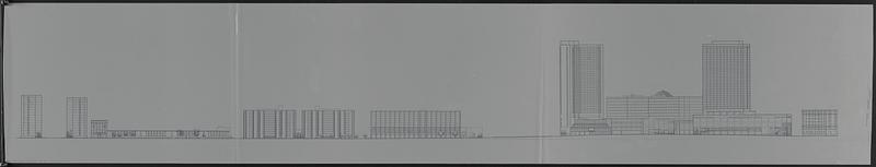
Profile of Huntington Avenue/St. James Avenue from Harcourt Street to Berkeley Street
Item Information
- Title:
- Profile of Huntington Avenue/St. James Avenue from Harcourt Street to Berkeley Street
- Cartographer:
- Boston Redevelopment Authority
- Date:
-
[ca. 1990–1999]
- Format:
-
Maps/Atlases
- Genre:
-
Panoramic views
profiles (orthographic projections)
Manuscript maps
- Location:
-
Boston Public Library
Norman B. Leventhal Map & Education Center - Collection (local):
-
Norman B. Leventhal Map & Education Center Collection
- Series:
- Boston Redevelopment Authority Maps & Manuscript Plans Collection
- Subjects:
-
Buildings--Massachusetts--Boston--Illustrations
Back Bay (Boston, Mass.)--Maps
- Places:
-
MassachusettsSuffolk (county)BostonBack Bay
- Extent:
- 1 manuscript profile : on plastic ; sheet 44 x 234 cm
- Terms of Use:
-
No known copyright restrictions.
No known restrictions on use.
- Place of origin:
-
[Boston]
- Scale:
-
Scale not given
- Language:
-
English
- Notes:
-
Manuscript profile in ink on a translucent mylar sheet depicting buildings and trees along the south side of Huntington Avenue/St. James Avenue from Harcourt Street to Berkeley Street.
- Identifier:
-
06_01_017839
- Call #:
-
BRA MAP FOLDER 30 no.7
- Barcode:
-
30000007747797


