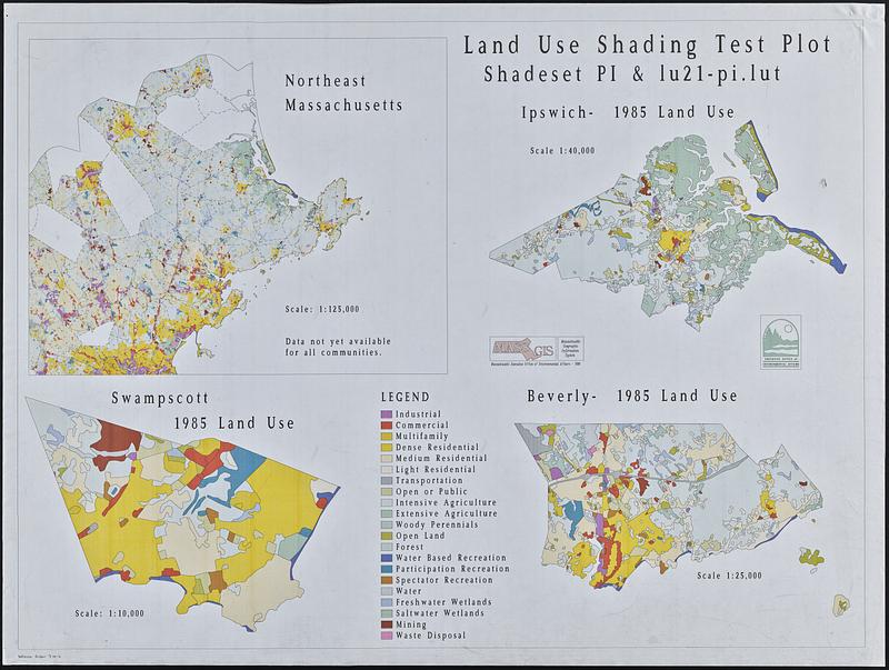
Land use shading test plot shadeset PI and lu21-pi.lut
Item Information
- Title:
- Land use shading test plot shadeset PI and lu21-pi.lut
- Cartographer:
- MassGIS (Office : Mass.)
- Cartographer:
- Massachusetts. Executive Office of Environmental Affairs
- Name on Item:
-
MassGIS ; Executive Office of Environmental Affairs
- Date:
-
1990
- Format:
-
Maps/Atlases
- Location:
-
Boston Public Library
Norman B. Leventhal Map & Education Center - Collection (local):
-
David Judkins Weaver Papers
- Subjects:
-
Beverly (Mass.)--Maps
Essex County (Mass.)--Maps
Ipswich (Mass. : Town)--Maps
Swampscott (Mass.)--Maps
Land use--Massachusetts--Beverly--Maps
Land use--Massachusetts--Essex County--Maps
Land use--Massachusetts--Ipswich (Town)--Maps
Land use--Massachusetts--Swampscott--Maps
Color in visual communication
- Places:
-
MassachusettsEssex (county)Beverly
MassachusettsEssex (county)Ipswich
MassachusettsEssex (county)Swampscott
- Extent:
- 4 maps on 1 sheet : color ; 87 x 117 cm
- Terms of Use:
-
No known copyright restrictions.
No known restrictions on use.
- Publisher:
-
[Boston] :
Massachusetts Executive Office of Environmental Affairs
- Scale:
-
Scales differ
- Language:
-
English
- Table of Contents:
-
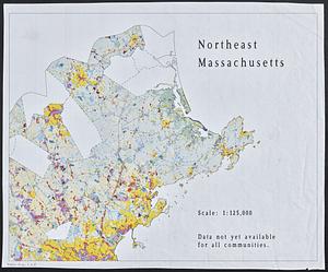
Northeast Massachusetts
Ipswich 1985 land use
Swampscott 1985 land use
Beverly 1985 land use
- Identifier:
-
06_01_018826
- Call #:
-
Weaver folder 9 no. 6