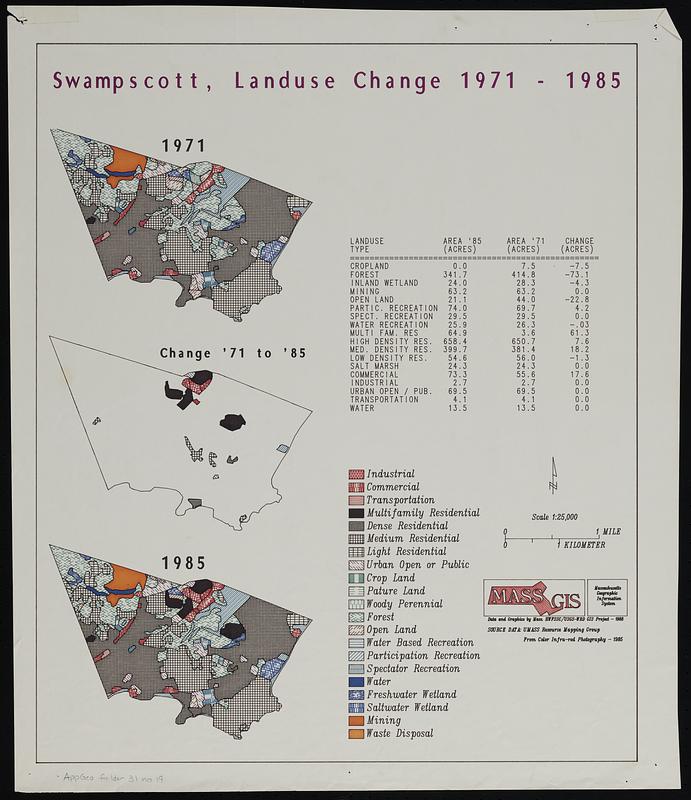
Swampscott, landuse change 1971-1985
Item Information
- Title:
- Swampscott, landuse change 1971-1985
- Title (alt.):
-
Swampscott, land use change 1971-1985
- Cartographer:
- MassGIS (Office : Mass.)
- Name on Item:
-
MassGIS
- Date:
-
1988
- Format:
-
Maps/Atlases
- Location:
-
Boston Public Library
Norman B. Leventhal Map & Education Center - Collection (local):
-
Applied Geographics, Inc. Records
- Subjects:
-
Swampscott (Mass.)--Maps
Land use--Massachusetts--Swampscott--Maps
- Places:
-
MassachusettsEssex (county)Swampscott
- Extent:
- 3 maps on 1 sheet : color ; 49 x 41 cm
- Terms of Use:
-
No known copyright restrictions.
No known restrictions on use.
- Scale:
-
Scale 1:25,000
- Language:
-
English
- Table of Contents:
-
1971
Change '71 to '85
1985.
- Notes:
-
Includes land use statistics.
- Identifier:
-
06_01_019079
- Call #:
-
AppGeo Folder 31 no. 19
- Barcode:
-
30000008064320