Toggle navigation
LMEC Home
Exhibitions
Georeferencing
Tools for Teachers
Collections
My Favorites
Sign Up / Log In
Search
Search the map portal
Map Collection
Map Collection
Map Sets
Search
Search
Search for
Search In
All Fields
Creator
Title
Subject
Place
Search All Digital Collections
Advanced Search
293 Results
My Search
Start Over
More Like
commonwealth:dz010v069
Remove constraint More Like: commonwealth:dz010v069
Filter your Search
Place
North and Central America
226
United States
158
New York
31
Suffolk (county)
31
Boston
29
Canada
27
North America
27
Charleston (county)
10
more
Place
»
Topic
North America--Maps--Early works to 1800
18
Boston (Mass.)--History--Revolution, 1775-1783--Maps--Early works to 1800
16
Vues d'optique
10
Gibraltar--History--Siege, 1779-1783--Maps--Early works to 1800
9
New York (N.Y.)--Pictorial works--Early works to 1800
9
United States--History--French and Indian War, 1754-1763--Maps--Early works to 1800
9
United States--Maps--Early works to 1800
9
Boston (Mass.)--Pictorial works--Early works to 1800
8
more
Topic
»
Date
Date range begin
–
Date range end
Current results range from
1740
to
1799
View distribution
Creator
Faden, William, 1749-1836
33
Jefferys, Thomas, -1771
29
Le Rouge, Georges-Louis
23
Des Barres, Joseph F. W. (Joseph Frederick Wallet), 1722-1824
21
Sayer, Robert, 1725-1794
19
Korn, Christoph Heinrich, 1726-1783
11
Raspe, Gabriel Nicolaus, 1712-1785
11
Simcoe, John Graves, 1752-1806
10
more
Creator
»
Format
Maps/Atlases
251
Prints
31
Manuscripts
23
Drawings/Illustrations
9
Books
2
Georeferenced
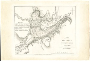
Yes
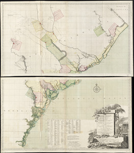
12
No
281
Collection
Richard H. Brown Revolutionary War Map Collection at Mount Vernon
293
American Revolutionary War-Era Maps
292
Boston and New England Maps
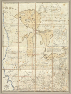
4
Maritime Charts and Atlases
2
Urban Maps
2
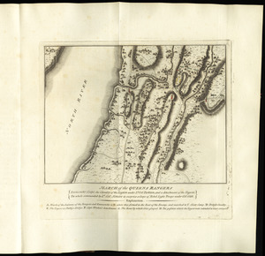
Available to use
Creative Commons license
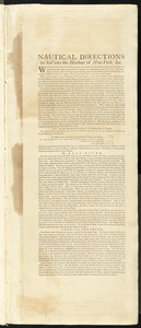
293
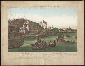
Search Constraints
Sort by relevance
relevance
title
date (asc)
date (desc)
Number of results to display per page
100 per page
10
per page
20
per page
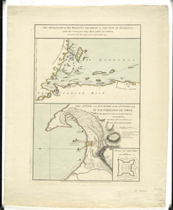
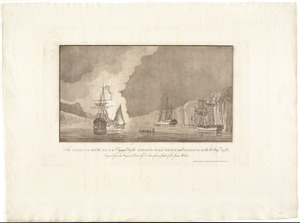
50
per page
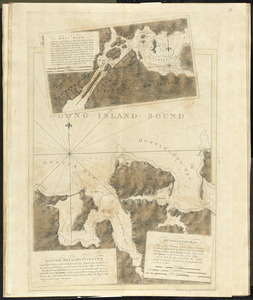
100
per page
View results as:
grid view
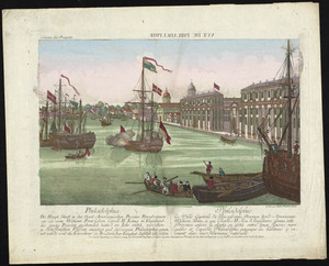
map view
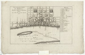
Search Results
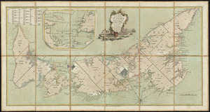
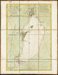
101.
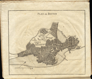
Les Isles Turques d'après les levées de 1753 par le sloop l'Aigle et l'Emeraude par ordre du Gouverneur de St. Domingue...
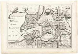
102.
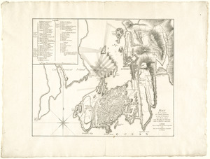
L'isthme de l'Acadie, Baye du Beaubassin, en Anglois Shegnekto, environs du Fort Beausejour
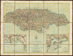
103.
La Jamaique
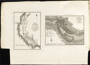
104.
Karte von dem Ostlichen-Stucke von Neu Franckreich oder Canada in America : besonders aber Acadia und Neu Schottland
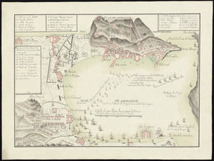
105.
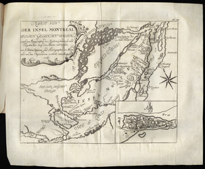
Karte von der Insel Montreal und den gegenden umher, nach den manuscripten der karten, grundrisse und tagebücher beÿ der...
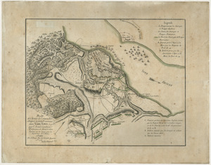
106.
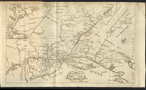
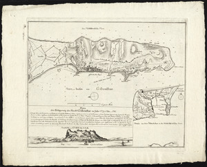
Karte von Neu England, Neu Yorck und Pensilvanien
107.
Krigs theatreni i America, 1777 = : seat of war in America, 1777
108.
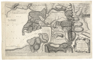
LʼAmérique Septentrionale et Méridionale divisée suivant ses différens pays
109.
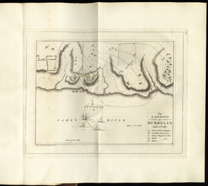
The landing at Burrell's, April 17th. 1781
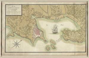
110.
A large and particular plan of Shegnekto Bay, and the circumjacent country, with the forts and settlements of the French 'till...
111.
Lauff des flusses St. Laurentzi von Quebec bis an den See Ontario : 2. bladt
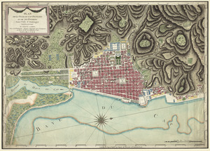
112.
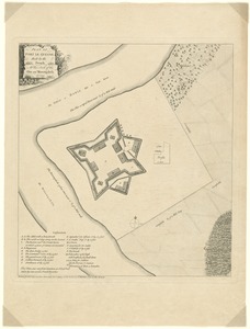
[Map of Boston]
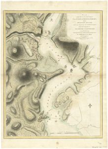
113.
[Map of Florida, Carolina, and the Gulf Coast]
114.
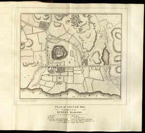
Map of Nova Scotia, or Acadia : with the islands of Cape Breton and St. John's, from actual surveys
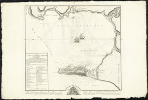
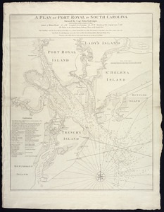
115.
A map of South Carolina and a part of Georgia : containing the whole sea-coast; all the islands, inlets, rivers, creeks,...
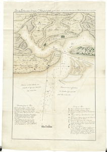
116.
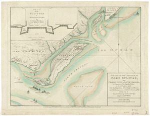
[Map of the Allegheny and Ohio Rivers] ; Franzosische see kusten von Provence zwischen Marseille und Toulon = : Cotes maritimes...
117.
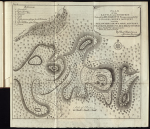
A map of the British and French dominions in North America with the roads, distances, limits, and extent of the settlements,...
118.
A map of the country between Will's Creek & Monongahela River shewing the rout and encampments of the English army in 1755
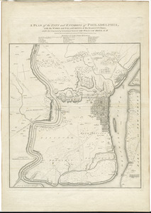
119.
A map of the inhabited part of Canada from the French surveys : with the frontiers of New York and New England from the large...
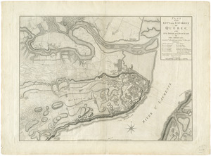
120.
A map of the most inhabited part of New England : containing the provinces of Massachusets Bay and New Hampshire, with the...
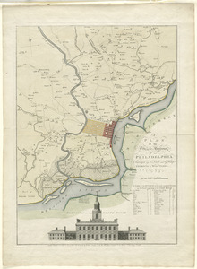
121.
A map of the most inhabited part of Virginia containing the whole province of Maryland with part of Pensilvania, New Jersey and...
122.
A map of the north west parts of the United States of America
123.
A map of the Province of New-York : reduc'd from the large drawing of that province, compiled from actual surveys by order of...
124.
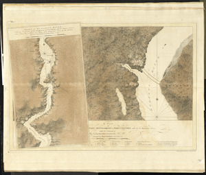
[Map of the Siege of Mud Island Fort]
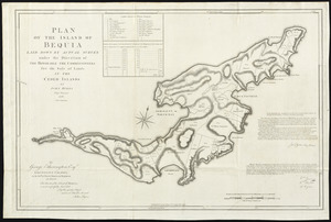
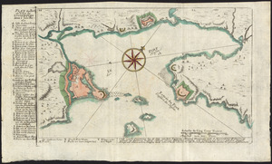
125.
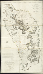
A map of the United States of N. America
126.
Map of the western parts of the colony of Virginia, as far as the Mississipi
127.
March of the Queens Rangers : Emmericks Corps, the Cavalry of the Legion under Lt. Col. Tarleton, and a detachment of the...
128.
Nachricht von der belagerung und einnahme der stadt und hafens Charlestown in America
129.
Nautical directions to sail into the harbour of New-York, &c.
130.
Neu Yorck = : La Nouvelle Yorck
131.
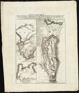
Neuester und acurater plan der weltberuhmten Englischen berg festung Gibraltar auf der Spitze von Spanien : derer wercher...
132.
A new and accurate map of the English empire in North America : representing their rightful claim as confirmed by charters, and...
133.
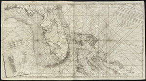
A new and correct chart of the coast of East Florida, and part of West Florida and Gulf of Mexico, Gulf of Florida or Cannel of...
134.
A new and correct map of North America, with the West India Islands : divided according to the last Treaty of Peace, concluded...
135.
A new chart of the coast of New England, Nova Scotia, and the islands of St. John, Cape Breton, Sable, the banks of St. Peters,...
136.
A new map of North America wherein the British Dominions in the continent of North America : and on the islands of the West...
137.
A new map of Nova Scotia, and Cape Britain : with the adjacent parts of New England and Canada, composed from a great number of...
138.
A new map of the British colonies in North America, shewing the seat of the present war, taken from the best surveys, compared...
139.
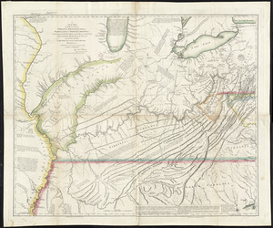
A new map of the western parts of Virginia, Pennsylvania, Maryland and North Carolina : comprehending the river Ohio, and all...
140.
[Noddle Island and the Mill Pond]
141.
North America from the French of Mr. D'Anville, improved with the back settlements of Virginia and course of Ohio, illustrated...
142.
The operations of His Majesty's squadron in the Bay of Honduras, under the command of the Hon. John Luttrell from the 15th of...
143.
Order of battle of the army under the command of Lt. General Gage at Boston, July 17th, 1775
144.
Oyster Bay and Huntington : Huntington Bay
145.
[Panoramic view of Newport, Rhode Island and the harbor showing the position of the French fleet and troop encampments]
146.
Partie occidentale de la Virginie, Pensylvanie, Maryland, et Caroline septle. la Rivière d'Ohio, et toutes celles qui s'y...
147.
Partie septentrionale des possessions angloise en Amérique : pour servire d'intelligence à la guerre présente entre les...
148.
Philadelphia = : Philadelphie
149.
Philadelphie, par Easburn, arpenteur general de Pensilvanie
150.
The Phoenix and the Rose engaged by the enemy's fire ships and galleys on the 16 Augst. 1776
151.
Plan de Boston
152.
Plan de Boston
153.
[Plan de Gibraltar]
154.
Plan de Gibraltar
155.
Plan de la position de l'armée française au tour de Newport dans Rhode Island et du mouillage de l'escadre dans la rade de...
156.
Plan de la ville de Louisbourg avec les ouvrages d'attaque des Anglais pour sa reddition, ainsi que ceux des assiegés pr. la...
157.
Plan de la ville du Cap Francois et de ses environs dans l'Isle St. Domingue
158.
Plan de la ville et des forts de Gibraltar, avec la Baye d'Algesiras
159.
Plan de la ville et du port de Boston : capitale de la Nouvelle Angleterre
160.
Plan de l'armée de Cornwallis attaquée et faitte prisoniere dans York Town : le 19 8bre par l'armée combinée Francaise et...
161.
Plan der belagerung der stadt Gibraltar im jahr 1779, 1780, 1781
162.
Plan der gegend des Ohio Flusses, wo ohnweit da von am 9 July 1755, zwischen denen Franzofichen u. Engl trouppen ein hiziges...
163.
Plan der gegend und stadt von Philadelphia
164.
Plan des befestigten lagers der Amerikaner bey Whitemarsh
165.
Plan des environs de New York (manuscrit) - Position du camp de l'armée combinée à Philippsburg du 6 juillet au 19 août -...
166.
Plan des jenigen treffen welches am 8. Sept 1755. zwischen dem Engl. Gen. Johnson, und dem Franz. Gen. Diesckau welcher dabey...
167.
Plan des villages de la contrée des Illinois et partie de la Riviere de Mississipi ; plan des Rapides de la Riviere d'Ohio
168.
Plan du fort et ville de Louisbourg dans l'Isle Roale
169.
Plan du Havre et de la barre de Ste. Marie par les Angloises appellée Amélia, ainsi que de la Barre dans la Floride orientale
170.
Plan du port et de la ville de Louisbourg en l'Isle Royale, et des attaques faites par les Anglois pendant le siége dépuis le...
171.
A plan of Boston, and its environs : shewing the true situation of His Majesty's army, and also those of the rebels
172.
A plan of Boston in New England with its environs : including Milton, Dorchester, Roxbury, Brooklin, Cambridge, Medford,...
173.
Plan of Fort le Quesne, built by the French at the fork of the Ohio and Monongahela in 1754
174.
A plan of Fort Montgomery & Fort Clinton, taken by His Majesty's forces, under the command of Maj. Genl. Sir Henry Clinton, K:B
175.
A plan of New York Island, and part of Long Island, with the circumjacent country, as far as Dobbs's Ferry to the north, and...
176.
A plan of New York Island, with part of Long Island, Staten Island & east New Jersey, with a particular description of the...
177.
Plan of Oyster Bay, as fortified by the Queen's Rangers
178.
A plan of Port Royal in South Carolina
179.
A plan of the action at Bunkers Hill, on the 17th. of June, 1775 : between His Majesty's troops under the command of Major...
180.
Plan of the action at Huberton under Brigadier Genl. Frazer, supported by Major Genl. Reidesel, on the 7th July 1777
181.
A plan of the attack of Fort Sulivan, near Charles Town in South Carolina : by a squadron of His Majesty's ships, on the 28th...
182.
Plan of the attack of the Forts Clinton & Montgomery, upon Hudsons River which were stormed by His Majestys forces under the...
183.
Plan of the battle near Bushy-Run gained by His Majesty's troops commanded by Colonel Henry Bouquet over the Delawares,...
184.
Plan of the battle, on Bunker's Hill : fought on the 17th of June 1775
185.
[Plan of the battles of Saratoga]
186.
A plan of the city and environs of Philadelphia : with the works and encampments of His Majesty's forces under the command of...
187.
A plan of the city and environs of Philadelphia
188.
Plan of the city and environs of Quebec, with its siege and blockade by the Americans, from the 8th of December 1775 to the...
189.
A plan of the city of New-York & its environs to Greenwich, on the North or Hudsons River, and to Crown Point, on the East or...
190.
A plan of the city of Philadelphia, the capital of Pennsylvania, from an actual survey
191.
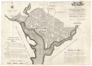
Plan of the city of Washington in the territory of Columbia, ceded by the states of Virginia and Maryland to the United States...
192.
A plan of the disposition of the advanced party consisting of 400 men : to defend the workers in making the road
193.
Plan of the encampment and position of the army under His Excelly. Lt. General Burgoyne at Bræmus Heights on Hudson's River...
194.
Plan of the encampment and position of the army under His Excelly. Lt. General Burgoyne at Swords House on Hudson's River near...
195.
A plan of the encampment of the detachment from the little Meadows
196.
A plan of the entrance of Chesapeak Bay, with James and York rivers : wherein are shewn the respective positions (in the...
197.
A plan of the field of battle and disposition of the troops, as they were on the march at the time of the attack on the 9th of...
198.
Plan of the island of Bequia laid down by actual survey under the direction of the honorable the Commissioners for the Sale of...
199.
Plan of the island of Dominica laid down by actual survey under the direction of the honorable the Commissioners for the Sale...
200.
A plan of the island of St. John with the divisions of the counties, parishes, & the lots as granted by government, likewise...
‹ Prev
Next ›
1
2
3


![[Map of Boston]](https://bpldcassets.blob.core.windows.net/derivatives/images/commonwealth:z603vw17n/image_thumbnail_300.jpg)
![[Map of Florida, Carolina, and the Gulf Coast]](https://bpldcassets.blob.core.windows.net/derivatives/images/commonwealth:z603vr379/image_thumbnail_300.jpg)

![[Map of the Allegheny and Ohio Rivers] ; Franzosische see kusten von Provence zwischen Marseille und Toulon =](https://bpldcassets.blob.core.windows.net/derivatives/images/commonwealth:z603vr31n/image_thumbnail_300.jpg)


![[Map of the Siege of Mud Island Fort]](https://bpldcassets.blob.core.windows.net/derivatives/images/commonwealth:z603vr43f/image_thumbnail_300.jpg)


![[Noddle Island and the Mill Pond]](https://bpldcassets.blob.core.windows.net/derivatives/images/commonwealth:dz010v671/image_thumbnail_300.jpg)


![[Panoramic view of Newport, Rhode Island and the harbor showing the position of the French fleet and troop encampments]](https://bpldcassets.blob.core.windows.net/derivatives/images/commonwealth:dz010v493/image_thumbnail_300.jpg)


![[Plan de Gibraltar]](https://bpldcassets.blob.core.windows.net/derivatives/images/commonwealth:z603vt83t/image_thumbnail_300.jpg)


![[Plan of the battles of Saratoga]](https://bpldcassets.blob.core.windows.net/derivatives/images/commonwealth:z603vw07d/image_thumbnail_300.jpg)
![A plan of the city of New-York & its environs to Greenwich, on the North or Hudsons River, and to Crown Point, on the East or Sound River, shewing the several streets, publick buildings, docks, fort & battery, with the true form & course of the commanding grounds, with and without the town : survey'd in the winter, 1775 [i.e. 1766]](https://bpldcassets.blob.core.windows.net/derivatives/images/commonwealth:z603vs09b/image_thumbnail_300.jpg)