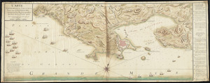
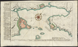
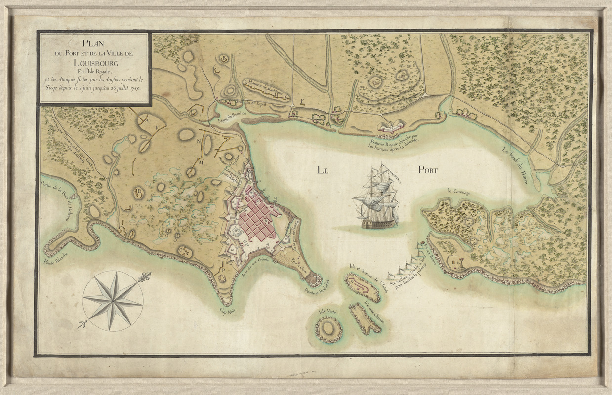
Plan du port et de la ville de Louisbourg en l'Isle Royale, et des attaques faites par les Anglois pendant le siége dépuis le 8 Juin jusqu'au 26 Juillet 1758
This map is also available in American Revolutionary Geographies Online (ARGO), a collections portal especially built for material relating to the American Revolutionary War Era. Visit ARGO to learn more about this item and explore the historical geography of North America in the late eighteenth century.
Item Information
- Title:
- Plan du port et de la ville de Louisbourg en l'Isle Royale, et des attaques faites par les Anglois pendant le siége dépuis le 8 Juin jusqu'au 26 Juillet 1758
- Description:
-
During the early 18th century, Île Royale – present-day Cape Breton Island – was home to a group of displaced French settlers from Newfoundland. A fortress was constructed in 1713 at Louisbourg, to protect French Canada from the enemy. The British laid siege to Louisbourg in 1758 during the French and Indian War. Prepared by a French cartographer, this map depicts the city and fortress during this six-week struggle. With a decisive British victory, the island was ceded to Britain by the Treaty of Paris in 1763, and renamed Cape Breton.
- Date:
-
[1758?]
- Format:
-
Maps/Atlases
- Location:
- George Washington's Mount Vernon
- Collection (local):
-
Richard H. Brown Revolutionary War Map Collection at Mount Vernon
- Subjects:
-
Nova Scotia--Maps
Louisbourg (N.S.)--History--Siege, 1758--Maps--Early works to 1800
United States--History--French and Indian War, 1754-1763--Maps--Early works to 1800
- Places:
-
CanadaNova Scotia (province)Louisbourg
CanadaNova Scotia (province)
- Extent:
- 1 ms. map : hand col. ; 41 x 70 cm.
- Terms of Use:
-
No known copyright restrictions.
This work is licensed for use under a Creative Commons Attribution Non-Commercial Share Alike License (CC BY-NC-SA).

- Publisher:
-
Paris :
[s.n.]
- Scale:
-
Scale [ca. 1:7,000]
- Language:
-
French
- Notes:
-
Manuscript map depicting the siege of Louisbourg during the French and Indian War.
Oriented with north to the upper right.
Relief shown by hachures.
In French.
- Notes (exhibitions):
-
Exhibited: "Charting an Empire: The Atlantic Neptune" organized by the Norman B. Leventhal Map Center at the Boston Public Library, 2013.
- Identifier:
-
06_01_009522