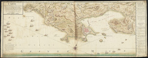
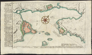
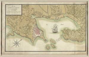
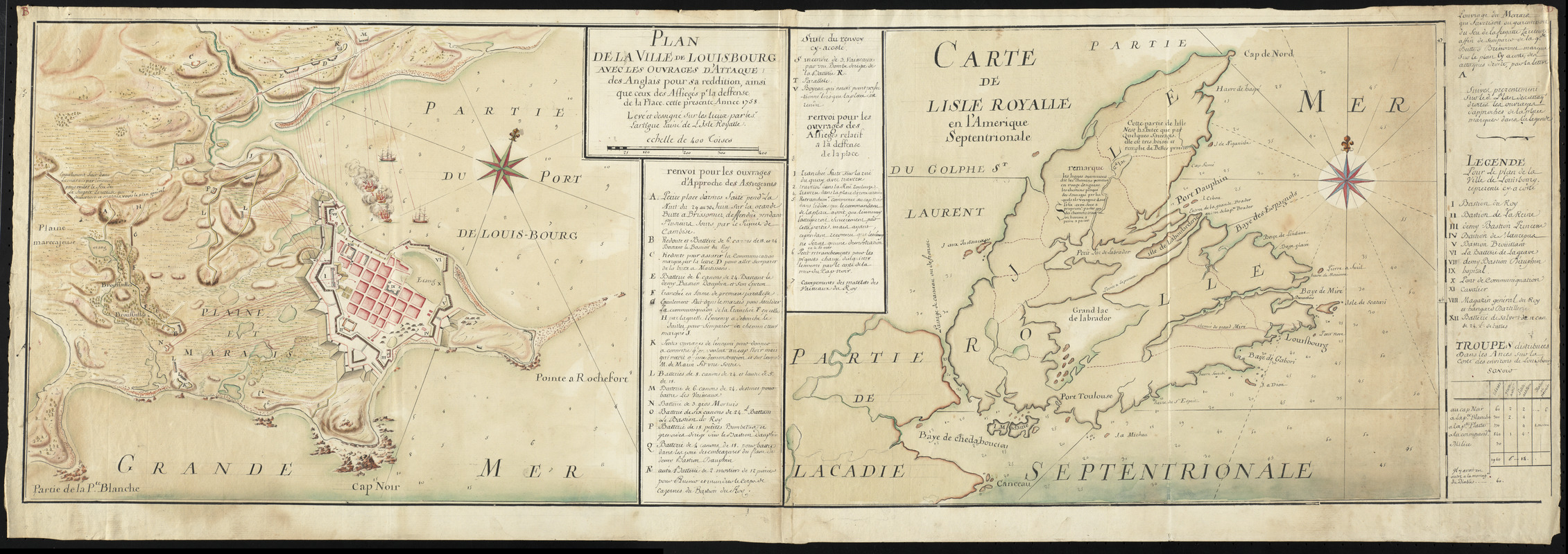
Plan de la ville de Louisbourg avec les ouvrages d'attaque des Anglais pour sa reddition, ainsi que ceux des assiegés pr. la deffense de la place, cette presente année 1758
This map is also available in American Revolutionary Geographies Online (ARGO), a collections portal especially built for material relating to the American Revolutionary War Era. Visit ARGO to learn more about this item and explore the historical geography of North America in the late eighteenth century.
Item Information
- Title:
- Plan de la ville de Louisbourg avec les ouvrages d'attaque des Anglais pour sa reddition, ainsi que ceux des assiegés pr. la deffense de la place, cette presente année 1758
- Description:
-
Lartigue (1729-1772) served as the King's Keeper of Stores until his removal from that office in 1752. The map of the fortress shows the positions of batteries of canon and mortar within and outside the fortress, described in detail in the key. The map of the province of Isle Royale, apart from the place names, offers two "remarques" on the native inhabitants of the northern peninsula: "This part of the Isle is inhabited only by some savages, it is very wooded and filled with beautiful meadows" and again "The lines otherwise called roads highlighted in red designate the beaten paths (les chemins plaqué) of the Savages by which they travel in the Isle. This is only, properly speaking, paths traced where one man can barely pass.
We Are One: During the early 18th century, Île Royale – present-day Cape Breton Island –became the home for displaced French settlers from Nova Scotia and Newfoundland. For their protection, the French constructed a massive citadel at Louisbourg. Beginning June 1, 1758, the British laid siege to the fort for six weeks. A decisive British victory at Louisbourg opened the St. Lawrence River for an attack on Quebec the next year. This pair of maps depicts the town, fortress, and island during the siege. Lartigue, a French-Canadian, prepared the maps 33 years before the first printed map was produced in Canada.
- Creator:
- Lartigue, Pierre-Jérome, 1729-1772
- Name on Item:
-
levé et dessigné sur les lieiux par le Sr. Lartigue l'ainé de l'Isle Royalle.
- Date:
-
[1758]
- Format:
-
Maps/Atlases
Manuscripts
- Location:
- George Washington's Mount Vernon
- Collection (local):
-
Richard H. Brown Revolutionary War Map Collection at Mount Vernon
- Subjects:
-
Louisbourg (N.S.)--History--Siege, 1758--Maps--Early works to 1800
United States--History--French and Indian War, 1754-1763--Maps--Early works to 1800
Cape Breton Island (N.S.)--Maps--Early works to 1800
- Places:
-
CanadaCape Breton Island (island)
CanadaLouisbourg
- Extent:
- 2 manuscript maps on 1 sheet : hand colored ; 33 x 43 cm. and 33 x 46 cm., on sheet 37 x 108 cm.
- Terms of Use:
-
No known copyright restrictions.
This work is licensed for use under a Creative Commons Attribution Non-Commercial Share Alike License (CC BY-NC-SA).

- Scale:
-
Scale [ca. 1:7,400]
Scale [ca. 1:600,000]
- Language:
-
French
- Catalog Record:
-
MVLA record
- Notes:
-
Relief shown by gradient tints. Depths shown by soundings.
In French.
Colored manuscript map of the 1758 siege of Louisbourg showing ships, troop positions, and batteries.
Includes references to points of interest.
Oriented with north to the upper right.
Colored manuscript map of Cape Breton Island showing fortifications and batteries.
Includes a table listing troop distribution, references to points of interest, and notes.
This map can be viewed as a georeferenced overlay in an interactive application made especially for We Are One: Mapping America's Road from Revolution to Independence http://d2o8owo4k087al.cloudfront.net/index.html?mapId=44a and http://d2o8owo4k087al.cloudfront.net/index.html?mapId=44b.
- Notes (date):
-
This date is inferred.
- Notes (exhibitions):
-
Exhibited: "We Are One: Mapping America's Road from Revolution to Independence" organized by the Norman B. Leventhal Map Center at the Boston Public Library, 2015.
- Identifier:
-
06_01_010463