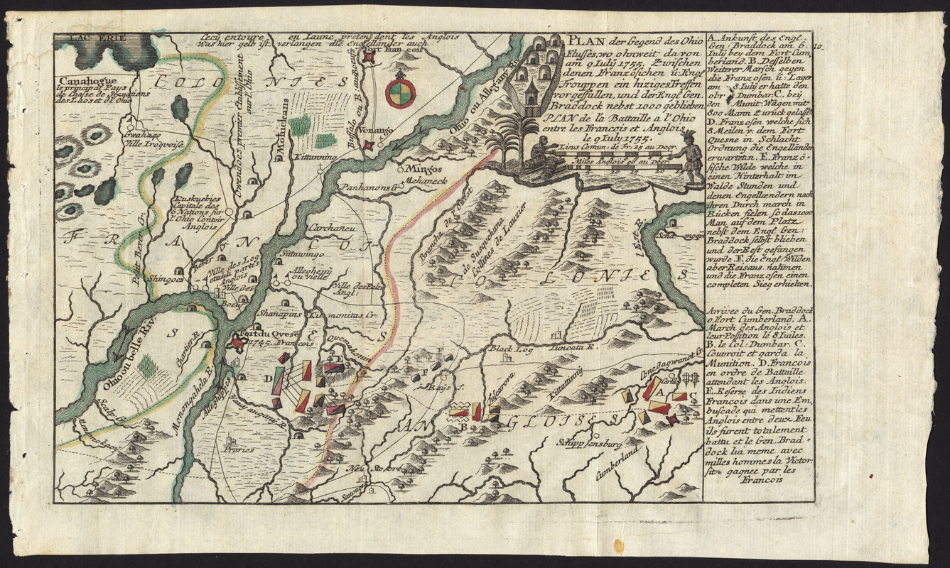
Plan der gegend des Ohio Flusses, wo ohnweit da von am 9 July 1755, zwischen denen Franzofichen u. Engl trouppen ein hiziges treffen vorgeffallen, und der Engl Gen. Braddock nebst 1000 geblieben = : Plan de la battaille a l'Ohio entre les Francois et Anglois le 9 July 1755
This map is also available in American Revolutionary Geographies Online (ARGO), a collections portal especially built for material relating to the American Revolutionary War Era. Visit ARGO to learn more about this item and explore the historical geography of North America in the late eighteenth century.
Item Information
- Title:
- Plan der gegend des Ohio Flusses, wo ohnweit da von am 9 July 1755, zwischen denen Franzofichen u. Engl trouppen ein hiziges treffen vorgeffallen, und der Engl Gen. Braddock nebst 1000 geblieben = : Plan de la battaille a l'Ohio entre les Francois et Anglois le 9 July 1755
- Title (alt.):
-
Plan de la battaille a l'Ohio entre les Francois et Anglois le 9 July 1755
- Creator:
- Heiden, Christian Friedrich von der
- Date:
-
[ca. 1760]
- Format:
-
Maps/Atlases
- Location:
- George Washington's Mount Vernon
- Collection (local):
-
Richard H. Brown Revolutionary War Map Collection at Mount Vernon
- Subjects:
-
Monongahela, Battle of the, Pa., 1755--Maps--Early works to 1800
Pennsylvania--History--French and Indian War, 1754-1763--Maps--Early works to 1800
Braddock, Edward, 1695?-1755
- Places:
-
Pennsylvania
- Extent:
- 1 map : hand col. ; 17 x 23 cm.
- Terms of Use:
-
No known copyright restrictions.
This work is licensed for use under a Creative Commons Attribution Non-Commercial Share Alike License (CC BY-NC-SA).

- Publisher:
-
Augsburg :
Christian Friedrich von der Heiden
- Scale:
-
Scale [ca. 1:1,000,000]
- Language:
-
German
French
- Catalog Record:
-
MVLA record
- Notes:
-
Shows military operations in the Battle of Monongahela.
Relief shown pictorially.
Includes references.
From von der Heiden's Americanische urquelle.
In upper right: 10.
In German and French.
- Identifier:
-
06_01_009536

![[Map of the Allegheny and Ohio Rivers] ; Franzosische see kusten von Provence zwischen Marseille und Toulon =](https://bpldcassets.blob.core.windows.net/derivatives/images/commonwealth:z603vr31n/image_thumbnail_300.jpg)
![[Monongahela] no. 2 : a sketch of the field of battle &c, shewing the disposition of the troops about 2 o'clock when the whole of the main body had joined the advanced and working partys then beat back from the ground they occupied as in plan no. 1](https://bpldcassets.blob.core.windows.net/derivatives/images/commonwealth:j3863670v/image_thumbnail_300.jpg)
![[A map of part of Pennsylvania & Maryland intended to shew, at one view, the several places proposed for opening a communication between the waters of the Delaware & Chesopeak Bays]](https://bpldcassets.blob.core.windows.net/derivatives/images/commonwealth:z603vt12v/image_thumbnail_300.jpg)

