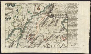
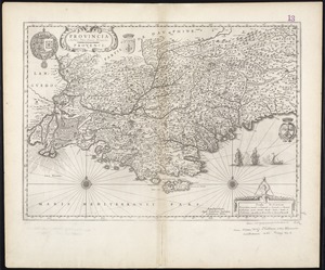
[Map of the Allegheny and Ohio Rivers] ; Franzosische see kusten von Provence zwischen Marseille und Toulon = : Cotes maritimes en Provence entre Marseille et Toulon
![[Map of the Allegheny and Ohio Rivers] ; Franzosische see kusten von Provence zwischen Marseille und Toulon =](https://bpldcassets.blob.core.windows.net/derivatives/images/commonwealth:z603vr31n/image_access_800.jpg)
This map is also available in American Revolutionary Geographies Online (ARGO), a collections portal especially built for material relating to the American Revolutionary War Era. Visit ARGO to learn more about this item and explore the historical geography of North America in the late eighteenth century.
Item Information
- Title:
- [Map of the Allegheny and Ohio Rivers] ; Franzosische see kusten von Provence zwischen Marseille und Toulon = : Cotes maritimes en Provence entre Marseille et Toulon
- Title (alt.):
-
Franzosische see kusten von Provence zwischen Marseille und Toulon =
- Creator:
- Heiden, Christian Friedrich von der
- Date:
-
[ca. 1760]
- Format:
-
Maps/Atlases
- Location:
- George Washington's Mount Vernon
- Collection (local):
-
Richard H. Brown Revolutionary War Map Collection at Mount Vernon
- Subjects:
-
Allegheny River (Pa. and N.Y.)--Maps--Early works to 1800
Ohio River--Maps--Early works to 1800
Pennsylvania--History--French and Indian War, 1754-1763--Maps--Early works to 1800
Provence (France)--Maps--Early works to 1800
- Places:
-
Allegheny River
Pennsylvania
Provence (area)
Ohio River
- Extent:
- 2 maps on 1 sheet : hand col. ; 7 x 32 cm. and 9 x 32 cm.
- Terms of Use:
-
No known copyright restrictions.
This work is licensed for use under a Creative Commons Attribution Non-Commercial Share Alike License (CC BY-NC-SA).

- Publisher:
-
Augsburg :
Christian Friedrich von der Heiden
- Scale:
-
Scale [ca. 1:400,000]
Scale [ca. 1:2,000,000]
- Language:
-
German
French
- Catalog Record:
-
MVLA record
- Notes:
-
Allegheny and Ohio River map shows forts and Indian tribes and includes notes about engagements.
Relief shown pictorially.
From von der Heiden's Americanische urquelle.
In upper right of Provence map: 32.
In German and French.
- Identifier:
-
06_01_009535


![[A map of part of Pennsylvania & Maryland intended to shew, at one view, the several places proposed for opening a communication between the waters of the Delaware & Chesopeak Bays]](https://bpldcassets.blob.core.windows.net/derivatives/images/commonwealth:z603vt12v/image_thumbnail_300.jpg)
