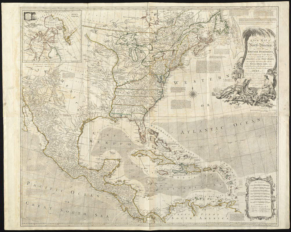
A new map of North America wherein the British Dominions in the continent of North America : and on the islands of the West Indies, are carefully laid down from all the surveys, hitherto made; and the boundaries of the new governments, as well as the other provinces are shewn. Also extracts from the definitive Treaty of Peace in 1763, relative to the cessions made to his Britannick Majesty on the continent of North America, and to the partition agreed on for the islands
This map is also available in American Revolutionary Geographies Online (ARGO), a collections portal especially built for material relating to the American Revolutionary War Era. Visit ARGO to learn more about this item and explore the historical geography of North America in the late eighteenth century.
Item Information
- Title:
- A new map of North America wherein the British Dominions in the continent of North America : and on the islands of the West Indies, are carefully laid down from all the surveys, hitherto made; and the boundaries of the new governments, as well as the other provinces are shewn. Also extracts from the definitive Treaty of Peace in 1763, relative to the cessions made to his Britannick Majesty on the continent of North America, and to the partition agreed on for the islands
- Creator:
- Delarochette, L. (Louis), 1731-1802
- Engraver:
- Kitchin, Thomas, d. 1784
- Publisher:
- Bowles, John, 1701-1779
- Name on Item:
-
this map laid down by Delarochette and engraved by Tho. Kitchin.
- Date:
-
[1763?]
- Format:
-
Maps/Atlases
- Location:
- George Washington's Mount Vernon
- Collection (local):
-
Richard H. Brown Revolutionary War Map Collection at Mount Vernon
- Subjects:
-
North America--Maps--Early works to 1800
- Places:
-
North America (area)
- Extent:
- 1 map : hand col. ; 100 x 117 cm.
- Terms of Use:
-
No known copyright restrictions.
This work is licensed for use under a Creative Commons Attribution Non-Commercial Share Alike License (CC BY-NC-SA).

- Publisher:
-
London :
Printed for John Bowles
- Scale:
-
Scale [ca. 1:5,500,000]
- Language:
-
English
- Catalog Record:
-
MVLA record
- Notes:
-
Relief shown pictorially.
Prime meridians: London and Ferro.
Includes notes, text, and inset "A map of the bays of Hudson and Baffin."
- Identifier:
-
06_01_008542


