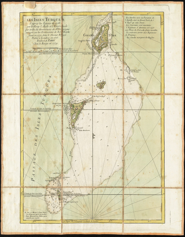
Les Isles Turques d'après les levées de 1753 par le sloop l'Aigle et l'Emeraude par ordre du Gouverneur de St. Domingue corrigées sur les observations de E-Hawke faites en 1770. dans le Shooner Royal ; publié a Londres en 1775
This map is also available in American Revolutionary Geographies Online (ARGO), a collections portal especially built for material relating to the American Revolutionary War Era. Visit ARGO to learn more about this item and explore the historical geography of North America in the late eighteenth century.
Item Information
- Title:
- Les Isles Turques d'après les levées de 1753 par le sloop l'Aigle et l'Emeraude par ordre du Gouverneur de St. Domingue corrigées sur les observations de E-Hawke faites en 1770. dans le Shooner Royal ; publié a Londres en 1775
- Creator:
- Le Rouge, Georges-Louis
- Contributor:
- Jefferys, Thomas, -1771
- Date:
-
1779
- Format:
-
Maps/Atlases
- Location:
- George Washington's Mount Vernon
- Collection (local):
-
Richard H. Brown Revolutionary War Map Collection at Mount Vernon
- Subjects:
-
Grand Turk Island (Turks and Caicos Islands)--Maps--Early works to 1800
Salt Cay (Turks and Caicos Islands)--Maps--Early works to 1800
Turks and Caicos Islands--Maps--Early works to 1800
- Places:
-
Turks Islands (area)
- Extent:
- 1 map : hand color ; 45 x 30 cm.
- Terms of Use:
-
No known copyright restrictions.
This work is licensed for use under a Creative Commons Attribution Non-Commercial Share Alike License (CC BY-NC-SA).

- Publisher:
-
Paris :
Le Rouge
- Scale:
-
Scale [ca. 1:90,000]
- Language:
-
French
- Catalog Record:
-
MVLA record
- Notes:
-
Covers Grand Turk Island, Salt Cay, and smaller islands in the vicinity. Shows topography and shoals.
Relief shown by hachures. Depths shown by soundings.
Prime meridian: London.
Includes notes.
Manuscript label on verso: No. 59. Les Isles Turques.
From the Library of the Ducs de Luynes from the Château de Dampierre.
- Notes (citation):
-
LC Maps of North America, 1750-1789, 1777
- Identifier:
-
06_01_010485
- Barcode:
-
30000003568443

![[A map of part of Pennsylvania & Maryland intended to shew, at one view, the several places proposed for opening a communication between the waters of the Delaware & Chesopeak Bays]](https://bpldcassets.blob.core.windows.net/derivatives/images/commonwealth:z603vt12v/image_thumbnail_300.jpg)


