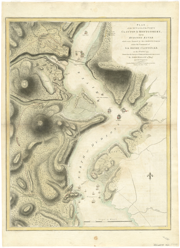
Plan of the attack of the Forts Clinton & Montgomery, upon Hudsons River which were stormed by His Majestys forces under the command of Sir Henry Clinton, K.B., on the 6th of Octr. 1777 : drawn from the surveys of Verplank, Holland & Metcalfe
This map is also available in American Revolutionary Geographies Online (ARGO), a collections portal especially built for material relating to the American Revolutionary War Era. Visit ARGO to learn more about this item and explore the historical geography of North America in the late eighteenth century.
Item Information
- Title:
- Plan of the attack of the Forts Clinton & Montgomery, upon Hudsons River which were stormed by His Majestys forces under the command of Sir Henry Clinton, K.B., on the 6th of Octr. 1777 : drawn from the surveys of Verplank, Holland & Metcalfe
- Creator:
- Hills, John, surveyor
- Contributor:
- Faden, William, 1749-1836
- Name on Item:
-
by John Hills, Lt. 23d. Regt. and asst. engineer.
- Date:
-
1784
- Format:
-
Maps/Atlases
- Location:
- George Washington's Mount Vernon
- Collection (local):
-
Richard H. Brown Revolutionary War Map Collection at Mount Vernon
- Subjects:
-
Fort Clinton, N.Y. (Rockland Co.)--History--Revolution, 1775-1783--Maps--Early works to 1800
Fort Montgomery State Historic Site (Highlands, N.Y.)--History--Revolution, 1775-1783--Maps--Early works to 1800
- Places:
-
Orange (county)Fort Montgomery
Rockland (county)Fort Clinton
Fort Clinton
- Extent:
- 1 map : hand col. ; 65 x 50 cm.
- Terms of Use:
-
No known copyright restrictions.
This work is licensed for use under a Creative Commons Attribution Non-Commercial Share Alike License (CC BY-NC-SA).

- Publisher:
-
London :
Wm. Faden
- Scale:
-
Scale [ca. 1:21,400]
- Language:
-
English
- Catalog Record:
-
MVLA record
- Notes:
-
Relief shown by hachures and shading.
- Identifier:
-
06_01_008235

![[A map of part of Pennsylvania & Maryland intended to shew, at one view, the several places proposed for opening a communication between the waters of the Delaware & Chesopeak Bays]](https://bpldcassets.blob.core.windows.net/derivatives/images/commonwealth:z603vt12v/image_thumbnail_300.jpg)


