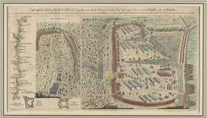
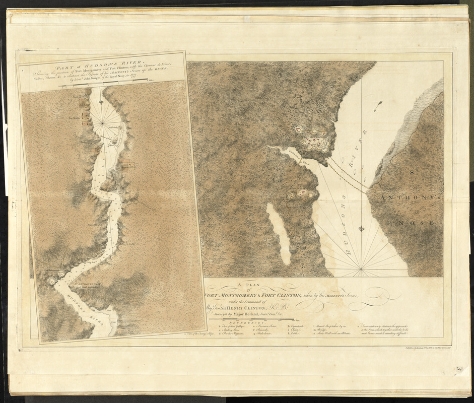
A plan of Fort Montgomery & Fort Clinton, taken by His Majesty's forces, under the command of Maj. Genl. Sir Henry Clinton, K:B
This map is also available in American Revolutionary Geographies Online (ARGO), a collections portal especially built for material relating to the American Revolutionary War Era. Visit ARGO to learn more about this item and explore the historical geography of North America in the late eighteenth century.
Item Information
- Title:
- A plan of Fort Montgomery & Fort Clinton, taken by His Majesty's forces, under the command of Maj. Genl. Sir Henry Clinton, K:B
- Title (alt.):
-
Plan of Fort Montgomery and Fort Clinton
- Creator:
- Holland, Samuel, 1728-1801
- Contributor:
- Des Barres, Joseph F. W. (Joseph Frederick Wallet), 1722-1824
- Name on Item:
-
survey'd by Major Holland, Survr. Genl. &c.
- Date:
-
1779
- Format:
-
Maps/Atlases
- Location:
- George Washington's Mount Vernon
- Collection (local):
-
Richard H. Brown Revolutionary War Map Collection at Mount Vernon
- Subjects:
-
Fort Montgomery State Historic Site (Highlands, N.Y.)--Maps--Early works to 1800
Hudson Highlands (N.Y.)--Maps--Early works to 1800
Hudson River (N.Y. and N.J.)--Maps--Early works to 1800
- Places:
-
Hudson River
Orange (county)Hudson Highlands State Park
Orange (county)Fort Montgomery
- Extent:
- 1 map : hand col. ; 39 x 75 cm.
- Terms of Use:
-
No known copyright restrictions.
This work is licensed for use under a Creative Commons Attribution Non-Commercial Share Alike License (CC BY-NC-SA).

- Publisher:
-
[London] :
J.F.W. Des Barres, Esqr.
- Scale:
-
Scale [ca. 1:18,000]
- Language:
-
English
- Catalog Record:
-
MVLA record
- Notes:
-
Relief shown by shading and hachures.
"Publish'd as the Act directs ..."
From volume five of Des Barres' Atlantic Neptune.
Scale statement based on description in LC Maps of North America, 1750-1789, 1191.
Scale not [ca. 1:6,000] as depicted by bar scale.
Watermark: JB, J Bates.
Includes ancillary map overlapping main map: Part of Hudsons River, shewing the position of Fort Montgomery and Fort Clinton : with the chevaux de frieze, cables, chains, & c to obstruct the passage of His Majesty's forces up the river / by Lieut. John Knight of the Royal Navy, in 1777. Scale [ca. 1:60,000]. Hand col. ; 45 x 30 cm. Depths shown by soundings.
- Identifier:
-
06_01_010110