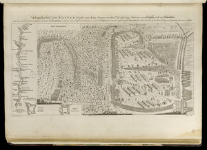
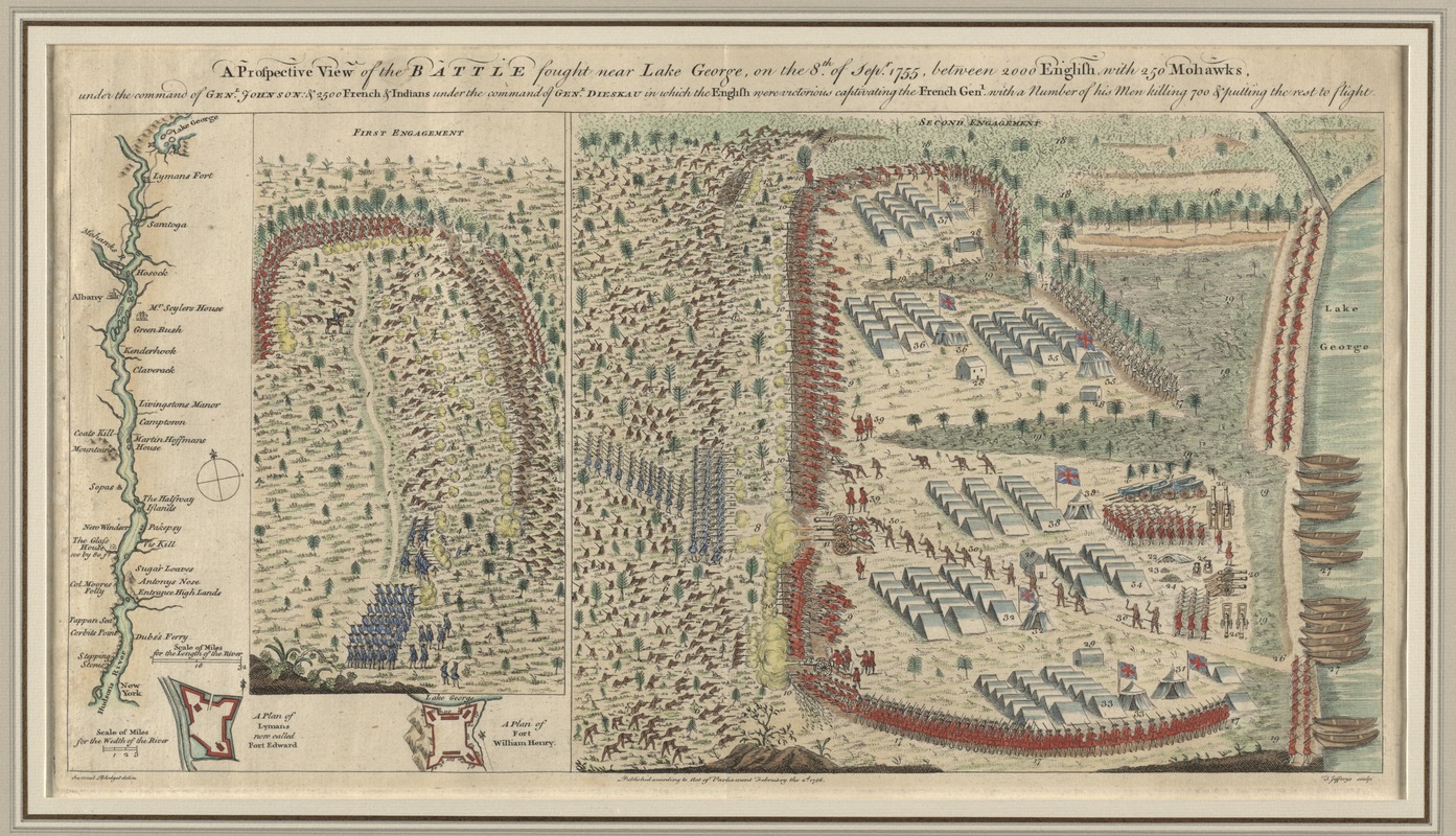
A prospective view of the battle fought near Lake George, on the 8th of Sepr. 1755, between 2000 English, with 250 Mohawks, under the command of Genl. Johnson : & 2500 French & Indians under the command of Genl. Dieskau in which the English were victorious captivating the French Genl. with a number of his men killing 700 & putting the rest to flight
This map is also available in American Revolutionary Geographies Online (ARGO), a collections portal especially built for material relating to the American Revolutionary War Era. Visit ARGO to learn more about this item and explore the historical geography of North America in the late eighteenth century.
Item Information
- Title:
- A prospective view of the battle fought near Lake George, on the 8th of Sepr. 1755, between 2000 English, with 250 Mohawks, under the command of Genl. Johnson : & 2500 French & Indians under the command of Genl. Dieskau in which the English were victorious captivating the French Genl. with a number of his men killing 700 & putting the rest to flight
- Description:
-
We Are One" British colonial troops wanted to capture Fort St. Frédéric (Crown Point), a French fortress on Lake Champlain, to gain control of the Lake Champlain corridor. Instead, they claimed victory at Lake George in September 1755. Samuel Blodget, a Massachusetts supplier to the troops, recorded these clashes based on his vantage point and eyewitness accounts. “The First Engagement” depicts the well-trained French troops, with Canadians and Native Americans, ambushing a hastily organized army of British colonists and Native Americans (including Mohawk Chief Hendrick). “The Second Engagement” depicts the failed French attack.
Made in Boston: This unusual plan of the Battle of Lake George was published in London by Thomas Jefferys just months after the events depicted. It is based closely on a plan of similar title engraved in Boston by Thomas Johnston. Cartographic plagiarism was rampant during this era, and though Blodget is credited in the lower-left margin, it is not clear whether Jefferys had obtained his permission to republish the plan. Unlike almost all known examples, this one is remarkable for displaying original color.
- Creator:
- Blodget, Samuel, 1724-1807
- Publisher:
- Jefferys, Thomas, -1771
- Name on Item:
-
Samuel Blodget delin. ; T. Jefferys sculp.
- Date:
-
1768
- Format:
-
Maps/Atlases
- Location:
- George Washington's Mount Vernon
- Collection (local):
-
Richard H. Brown Revolutionary War Map Collection at Mount Vernon
- Subjects:
-
Lake George, Battle of, N.Y., 1755--Aerial views--Early works to 1800
Fort William Henry (N.Y.)--History--French and Indian War, 1754-1763--Aerial views--Early works to 1800
Lake George (N.Y. : Town)--History--French and Indian War, 1754-1763--Aerial views--Early works to 1800
Hudson River (N.Y. and N.J.)--Maps--Early works to 1800
- Places:
-
Hudson River
Warren (county)Lake George
Warren (county)Fort William Henry (area)
- Extent:
- 2 views on 1 sheet ; 26 x 51 cm.
- Terms of Use:
-
No known copyright restrictions.
This work is licensed for use under a Creative Commons Attribution Non-Commercial Share Alike License (CC BY-NC-SA).

- Publisher:
-
[London] :
T. Jefferys
- Scale:
-
Not drawn to scale
- Language:
-
English
- Table of Contents:
-
[Hudson River]
A plan of Lymans now called Fort Edward
A plan of Fort William Henry
First Engagement
Second Engagement.
- Catalog Record:
-
MVLA record
- Notes:
-
Bird's-eye view.
Relief shown pictorially.
Appears in Jefferys' General topography of North America and the West Indies. London: Printed for Robert Sayer, ... and Thomas Jefferys, 1768.
- Notes (citation):
-
Phillips, 1196
- Notes (exhibitions):
-
Exhibited: "Made in Boston" organized by the Norman B. Leventhal Map Center at the Boston Public Library, 2013-2014.
Exhibited: "We Are One: Mapping America's Road from Revolution to Independence" organized by the Norman B. Leventhal Map Center at the Boston Public Library, 2015.
- Identifier:
-
06_01_008537
- Barcode:
-
30000002831087