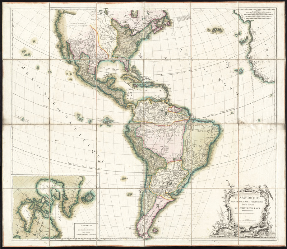
LʼAmérique Septentrionale et Méridionale divisée suivant ses différens pays
This map is also available in American Revolutionary Geographies Online (ARGO), a collections portal especially built for material relating to the American Revolutionary War Era. Visit ARGO to learn more about this item and explore the historical geography of North America in the late eighteenth century.
Item Information
- Title:
- LʼAmérique Septentrionale et Méridionale divisée suivant ses différens pays
- Description:
-
This general map of the Americas was produced by the firm of Vaugondy. Gilles Robert de Vaugondy was the leading French globemaker of the 18th century, and was appointed geographer to Louis XV in 1734. Like "L'Amerique divisée en ses principaux Etats" by Lattre and Bonne from 1788, this map shows the new boundaries of North America as a result of the Treaty of Paris in 1783. The newly created United States, along with Spanish lands in the south are clearly delineated. This may be the fourth state of the map, however it is not listed in Pedley's "Bel et Utile."
- Creator:
- Robert de Vaugondy, Gilles, 1688-1766
- Publisher:
- Delamarche, Charles François, 1740-1817
- Engraver:
- Arrivet, J.
- Name on Item:
-
par le Sr. Robert de Vaugondy, géographe ; Arrivet, inv. & sculp.
- Date:
-
[1792]
- Format:
-
Maps/Atlases
- Location:
- George Washington's Mount Vernon
- Collection (local):
-
Richard H. Brown Revolutionary War Map Collection at Mount Vernon
- Subjects:
-
North America--Maps--Early works to 1800
South America--Maps--Early works to 1800
- Places:
-
South America
North America (area)
- Extent:
- 1 map : hand col. ; 97 x 111 cm.
- Terms of Use:
-
No known copyright restrictions.
This work is licensed for use under a Creative Commons Attribution Non-Commercial Share Alike License (CC BY-NC-SA).

- Publisher:
-
Paris :
Chez le cit. Delamarche
- Scale:
-
Scale [ca. 1:11,500,000]
- Language:
-
French
- Catalog Record:
-
MVLA record
- Notes:
-
Prime meridian: [Ferro].
Relief shown pictorially.
Later state that is not recorded in Pedley's Bel et utile.
Inset: Supplement pour les terres Arctiques où se trouvent les bayes dʼHudson et de Baffin.
- Notes (date):
-
This date is inferred.
- Identifier:
-
06_01_009605


