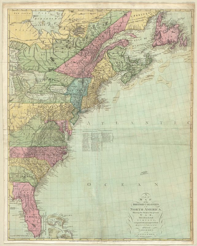
A new map of the British colonies in North America, shewing the seat of the present war, taken from the best surveys, compared with and improved from manuscripts of several noblemen and gentlemen
This map is also available in American Revolutionary Geographies Online (ARGO), a collections portal especially built for material relating to the American Revolutionary War Era. Visit ARGO to learn more about this item and explore the historical geography of North America in the late eighteenth century.
Item Information
- Title:
- A new map of the British colonies in North America, shewing the seat of the present war, taken from the best surveys, compared with and improved from manuscripts of several noblemen and gentlemen
- Creator:
- Andrews, John, 1736-1809
- Publisher:
- Harris, John, 1756-1846
- Name on Item:
-
by John Andrews ; drawn and engraved by John Andrews.
- Date:
-
1781
- Format:
-
Maps/Atlases
- Location:
- George Washington's Mount Vernon
- Collection (local):
-
Richard H. Brown Revolutionary War Map Collection at Mount Vernon
- Subjects:
-
North America--Maps--Early works to 1800
- Places:
-
North America (area)
- Extent:
- 1 map : hand col. ; 97 x 78 cm.
- Terms of Use:
-
No known copyright restrictions.
This work is licensed for use under a Creative Commons Attribution Non-Commercial Share Alike License (CC BY-NC-SA).

- Publisher:
-
London :
John Andrews ; John Harris
- Scale:
-
Scale [ca. 1:13,300,000]
- Language:
-
English
- Catalog Record:
-
MVLA record
- Notes:
-
Shows eastern United States and Canada.
Relief shown pictorially.
Includes references to names of counties not inserted on the map.
- Identifier:
-
06_01_009577


