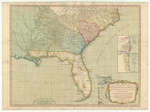
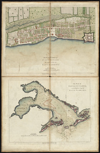
[Map of Florida, Carolina, and the Gulf Coast]
![[Map of Florida, Carolina, and the Gulf Coast]](https://bpldcassets.blob.core.windows.net/derivatives/images/commonwealth:z603vr379/image_access_800.jpg)
This map is also available in American Revolutionary Geographies Online (ARGO), a collections portal especially built for material relating to the American Revolutionary War Era. Visit ARGO to learn more about this item and explore the historical geography of North America in the late eighteenth century.
Item Information
- Title:
- [Map of Florida, Carolina, and the Gulf Coast]
- Title (alt.):
-
Delineatio munimenti et Portus S. Augustini
- Creator:
- Heiden, Christian Friedrich von der
- Date:
-
[ca. 1760]
- Format:
-
Maps/Atlases
- Location:
- George Washington's Mount Vernon
- Collection (local):
-
Richard H. Brown Revolutionary War Map Collection at Mount Vernon
- Subjects:
-
Saint Augustine (Fla.)--Maps--Early works to 1800
Southern States--Maps--Early works to 1800
- Places:
-
Southern United States (area)
Saint Johns (county)Saint Augustine
- Extent:
- 2 maps on 1 sheet : hand col. ; 13 x 16 cm. and 16 x 7 cm.
- Terms of Use:
-
No known copyright restrictions.
This work is licensed for use under a Creative Commons Attribution Non-Commercial Share Alike License (CC BY-NC-SA).

- Publisher:
-
Augsburg :
Christian Friedrich von der Heiden
- Scale:
-
Scale [ca. 1:150,000]
Scale [ca. 1:1,500,000]
- Language:
-
German
- Catalog Record:
-
MVLA record
- Notes:
-
Relief shown pictorially.
From von der Heiden's Americanische urquelle.
In upper right: 55.
In German.
- Identifier:
-
06_01_009539