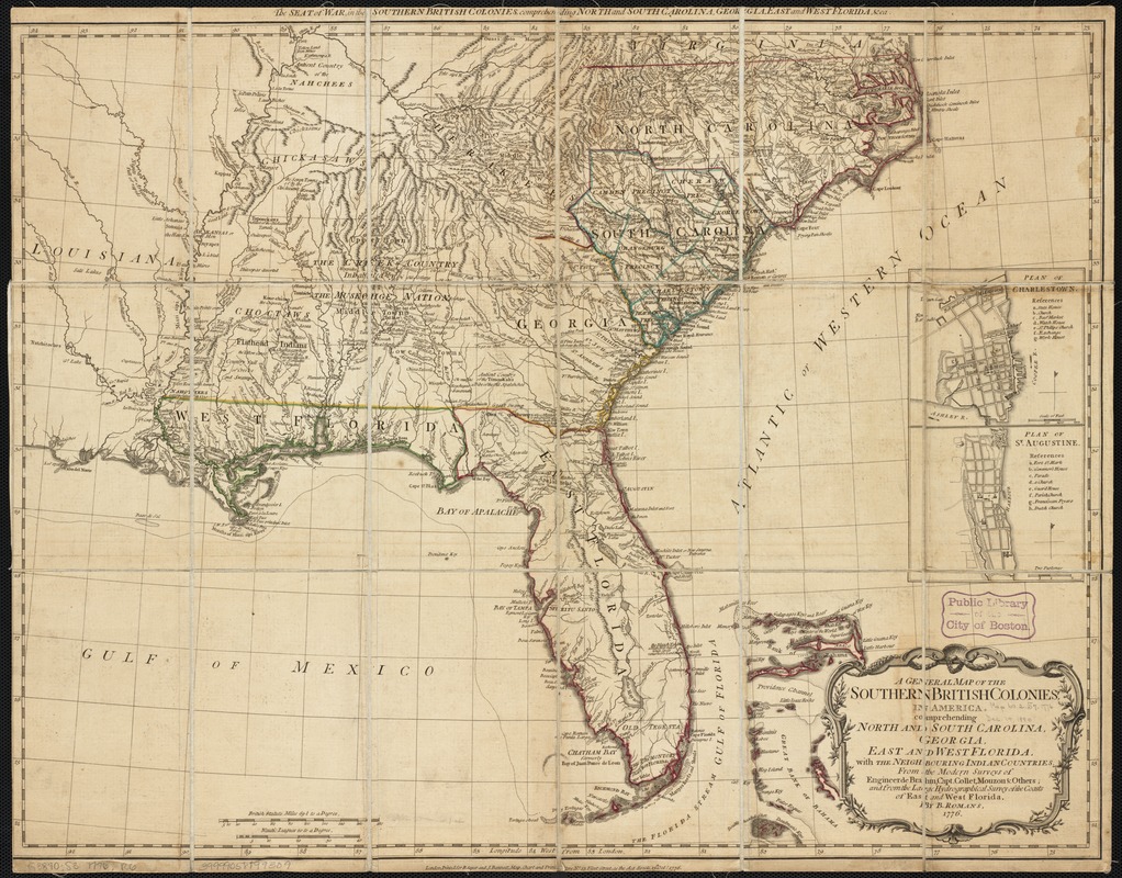
A general map of the southern British colonies in America comprehending North and South Carolina, Georgia, East and West Florida, with the neighbouring Indian countries : From the modern surveys of engineer de Brahm, Capt. Collet, Mouzon & others; and from the large hydrographical survey of the coasts of East and West Florida
This map is also available in American Revolutionary Geographies Online (ARGO), a collections portal especially built for material relating to the American Revolutionary War Era. Visit ARGO to learn more about this item and explore the historical geography of North America in the late eighteenth century.
Item Information
- Title:
- A general map of the southern British colonies in America comprehending North and South Carolina, Georgia, East and West Florida, with the neighbouring Indian countries : From the modern surveys of engineer de Brahm, Capt. Collet, Mouzon & others; and from the large hydrographical survey of the coasts of East and West Florida
- Title (alt.):
-
Seat of war in the southern British colonies comprehending North and South Carolina, Georgia, East and West Florida, &ca
- Creator:
- Romans, Bernard, 1741?-ca. 1784
- Name on Item:
-
by B. Romans, 1776.
- Date:
-
1776
- Format:
-
Maps/Atlases
- Location:
-
Boston Public Library
Norman B. Leventhal Map & Education Center - Collection (local):
-
Norman B. Leventhal Map & Education Center Collection
- Subjects:
-
Southern States--Maps--Early works to 1800
Charleston (S.C.)--Maps--Early works to 1800
Saint Augustine (Fla.)--Maps--Early works to 1800
United States--History--Revolution, 1775-1783--Maps--Early works to 1800
- Places:
-
South CarolinaCharleston (county)Charleston
Southern United States (area)
FloridaSaint Johns (county)Saint Augustine
- Extent:
- 1 map : outline col. ; 51 x 66 cm.
- Terms of Use:
-
No known copyright restrictions.
No known restrictions on use.
- Publisher:
-
London :
R. Sayer and J. Bennett, no. 53 Fleet Street
- Scale:
-
Scale [ca. 1:3,000,000]
- Language:
-
English
- Notes:
-
Relief shown pictorially.
Insets: Plan of Charlestown -- Plan of St. Augustine.
In The American military pocket atlas (London : R. Sayer and J Bennet, [1776]), no. 5.
- Identifier:
-
06_01_003199
- Call #:
-
G3871.S3 1776 .R6
- Barcode:
-
39999058999309


![[Map of Florida, Carolina, and the Gulf Coast]](https://bpldcassets.blob.core.windows.net/derivatives/images/commonwealth:z603vr379/image_thumbnail_300.jpg)
