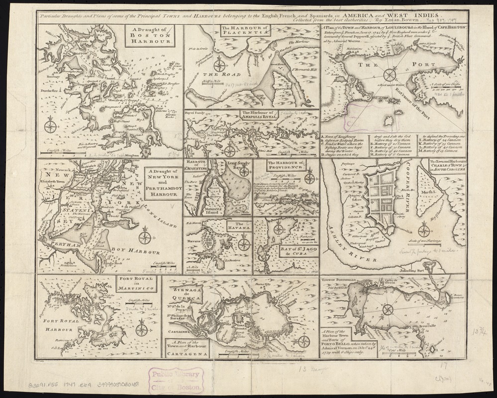
Particular draughts and plans of some of the principal towns and harbours belonging to the English, French, and Spaniards, in America and West Indies
This map is also available in American Revolutionary Geographies Online (ARGO), a collections portal especially built for material relating to the American Revolutionary War Era. Visit ARGO to learn more about this item and explore the historical geography of North America in the late eighteenth century.
Item Information
- Title:
- Particular draughts and plans of some of the principal towns and harbours belonging to the English, French, and Spaniards, in America and West Indies
- Creator:
- Bowen, Emanuel, d. 1767
- Name on Item:
-
collected from the best authorities by Eman. Bowen.
- Date:
-
[1747?]
- Format:
-
Maps/Atlases
- Location:
-
Boston Public Library
Norman B. Leventhal Map & Education Center - Collection (local):
-
Norman B. Leventhal Map & Education Center Collection
- Subjects:
-
Harbors--America--Maps--Early works to 1800
Harbors--Massachusetts--Boston--Maps--Early works to 1800
Nautical charts--Massachusetts--Boston--Early works to 1800
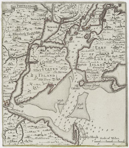
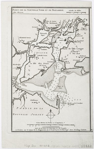
Nautical charts--New York (State)--New York--Early works to 1800
Harbors--New York (State)--New York--Maps--Early works to 1800
Harbors--New Jersey--Maps--Early works to 1800
Nautical charts--New Jersey--Early works to 1800
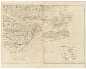
Nautical charts--Florida--Saint Augustine--Early works to 1800
Harbors--Florida--Saint Augustine--Maps--Early works to 1800
Nautical charts--Panama--Portobelo--Early works to 1800
Harbors--Panama--Portobelo--Maps--Early works to 1800
New York Harbor (N.Y. and N.J.)--Maps--Early works to 1800
Boston (Mass.)--Maps--Early works to 1800
New York (N.Y.)--Maps--Early works to 1800
Fort-de-France Bay (Martinique)--Maps--Early works to 1800
Placentia Bay (N.L.)--Maps--Early works to 1800
Annapolis Basin (N.S.)--Maps--Early works to 1800
Saint Augustine (Fla.)--Maps--Early works to 1800
Nassau (Bahamas)--Maps--Early works to 1800
Havana (Cuba)--Maps--Early works to 1800
Santiago de Cuba (Cuba)--Maps--Early works to 1800
Cartagena (Colombia)--Maps--Early works to 1800
Louisbourg (N.S.)--Maps--Early works to 1800
Charleston (S.C.)--Maps--Early works to 1800
Portobelo (Panama)--Maps--Early works to 1800
- Places:
-
CanadaNova Scotia (province)Annapolis Basin (bay)
MassachusettsSuffolk (county)Boston
ColombiaBolívarCartagena
CubaHavana (province)Havana
New YorkNew York
Martinique (territory)Fort-de-France, Baie de (bay)
FloridaSaint Johns (county)Saint Augustine
South CarolinaCharleston (county)Charleston
CubaSantiago de Cuba (province)Santiago de Cuba
PanamaColón (province)Portobelo
CanadaNewfoundland and Labrador (province)Placentia Bay
BahamasNew Providence (island)Nassau
CanadaNova Scotia (province)Louisbourg
- Extent:
- 13 maps on 1 sheet ; 35 x 43 cm.
- Terms of Use:
-
No known copyright restrictions.
No known restrictions on use.
- Publisher:
-
[London] :
Eman. Bowen
- Scale:
-
Scales differ.
- Language:
-
English
- Table of Contents:
-
A draught of Boston Harbour
The harbour of Placentia
A plan of the town and harbour of Louisbourg in the island of Cape Breton
A draught of New York and Perthamboy Harbour
The harbour of Providence
The town and harbour of Charles Town in South Carolina
Fort Royal in Martinico
A plan of the town and harbour of Cartagena
A plan of the harbour town and forts of Porto Bello.
- Notes:
-
Relief shown pictorially. Depths shown by soundings.
"No. 105" lower left corner.
Cataloging, conservation, and digitization made possible in part by The National Endowment for the Humanities: Exploring the human endeavor.
- Identifier:
-
06_01_007217
- Call #:
-
G3291.P55 1747 .B69
- Barcode:
-
39999059030138