Toggle navigation
LMEC Home
Exhibitions
Georeferencing
Tools for Teachers
Collections
My Favorites
Sign Up / Log In
Search
Search the map portal
Map Collection
Map Collection
Map Sets
Search
Search
Search for
Search In
All Fields
Creator
Title
Subject
Place
Search All Digital Collections
Advanced Search
8731 Results
My Search
Start Over
More Like
commonwealth:9s161c45m
Remove constraint More Like: commonwealth:9s161c45m
Filter your Search
Place
North and Central America
5,952
United States
4,877
Massachusetts
2,078
Europe
1,396
Suffolk (county)
1,045
Boston
1,018
Canada
450
Asia
438
more
Place
»
Topic
Boston (Mass.)--Maps
586
United States--Maps
282
Real property--Massachusetts--Boston--Maps
175
Massachusetts--Maps
162
Landowners--Massachusetts--Boston--Maps
133
North America--Maps--Early works to 1800
105
New England--Maps
102
Europe--Maps
79
more
Topic
»
Date
Date range begin
–
Date range end
Current results range from
1482
to
2023
View distribution
Creator
United States. Hydrographic Office
595
O.H. Bailey & Co
148
Des Barres, Joseph F. W. (Joseph Frederick Wallet), 1722-1824
123
United States. Post Office Dept
120
Ptolemy, 2nd cent
100
Walling, Henry Francis, 1825-1888
94
Jefferys, Thomas, -1771
87
Geological Survey (U.S.)
86
more
Creator
»
Format
Maps/Atlases
8,671
Manuscripts
216
Prints
56
Books
36
Objects/Artifacts
10
Drawings/Illustrations
8
Posters
5
Georeferenced
Yes
869
No
7,862
Collection
Norman B. Leventhal Map & Education Center Collection
8,693
Boston and New England Maps
2,232
Urban Maps
2,024
Maritime Charts and Atlases
1,083
American Revolutionary War-Era Maps
651
Boston Redevelopment Authority Collection
87
Richard H. Brown Revolutionary War Map Collection at Mount Vernon
11
MacLean Collection Map Library
8
more
Collection
»
Available to use
No known restrictions
8,554
Creative Commons license
72
Search Constraints
Sort by relevance
relevance
title
date (asc)
date (desc)
Number of results to display per page
20 per page
10
per page
20
per page
50
per page
100
per page
View results as:
grid view
map view
Search Results
1.
A new and general map of the Southern dominions belonging to the United States of America, viz North Carolina, South Carolina,...
2.
A new and general map of the southern dominions belonging to the United States of America, viz: North Carolina, South Carolina...
3.
Particular draughts and plans of some of the principal towns and harbours belonging to the English, French, and Spaniards, in...
4.
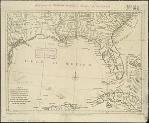
[Map of Florida, Carolina, and the Gulf Coast]
5.
Charles-town, capitale de la Caroline
6.
A chart of South Carolina and Georgia
7.
A chart of South Carolina and Georgia
8.
A chart of South Carolina and Georgia
9.
A new mapp of Carolina
10.
Plans des isles, rades, et ports de plusieurs lieux de l'Amérique : tirés de la Carte angloise de Mr. Popple publiée en 1733...
11.
Carte de la Virginie, du Maryland et de l'etat de Delaware
12.
Carte des deux Carolines et de la Géorgie
13.
Les costes aux environs de la Riviere de Misisipi : decouvertes par Mr. de la Salle en 1683 et reconnues par Mr. le Chevallier...
14.
Florida called by ye French Louisiana &c
15.
Florida from the latest authorities
16.
La Floride, suivant les nouvelles observations de Messrs. de l'Academie des Sciences, etc : augmentées de Nouveau
17.
Georgia, from the latest authorities
18.
A map of East and West Florida, Georgia, and Louisiana, with the islands of Cuba, Bahama, and the countries surrounding the...
19.
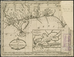
Map of the province of West Florida
20.
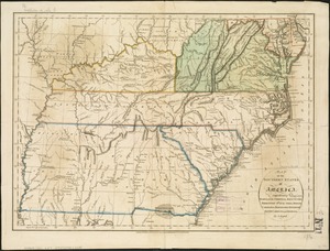
Map of the southern states of America, comprehending Maryland, Virginia, Kentucky, Territory s'th of the Ohio, North Carolina,...
‹ Prev
Next ›
1
2
3
4
5
…
436
437


![[Map of Florida, Carolina, and the Gulf Coast]](https://bpldcassets.blob.core.windows.net/derivatives/images/commonwealth:z603vr379/image_thumbnail_300.jpg)