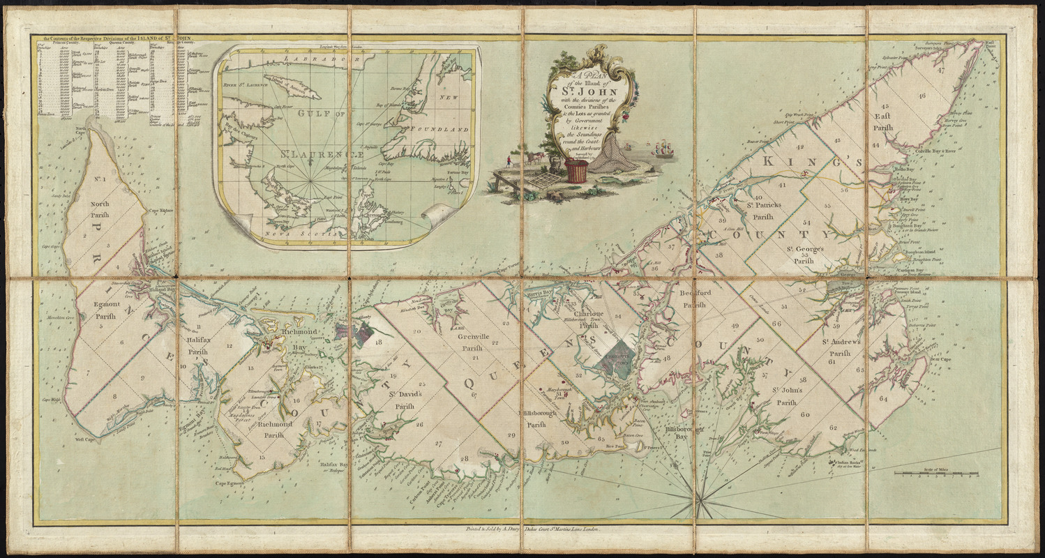
A plan of the island of St. John with the divisions of the counties, parishes, & the lots as granted by government, likewise the soundings round the coast and harbours
This map is also available in American Revolutionary Geographies Online (ARGO), a collections portal especially built for material relating to the American Revolutionary War Era. Visit ARGO to learn more about this item and explore the historical geography of North America in the late eighteenth century.
Item Information
- Title:
- A plan of the island of St. John with the divisions of the counties, parishes, & the lots as granted by government, likewise the soundings round the coast and harbours
- Creator:
- Holland, Samuel, 1728-1801
- Publisher:
- Dury, Andrew
- Name on Item:
-
survey'd by Capt. Holland.
- Date:
-
[1775]
- Format:
-
Maps/Atlases
- Location:
- George Washington's Mount Vernon
- Collection (local):
-
Richard H. Brown Revolutionary War Map Collection at Mount Vernon
- Subjects:
-
Prince Edward Island--Administrative and political divisions--Maps--Early works to 1800
- Places:
-
CanadaProvince of Prince Edward Island (province)
- Extent:
- 1 map : hand col. ; 36 x 70 cm.
- Terms of Use:
-
No known copyright restrictions.
This work is licensed for use under a Creative Commons Attribution Non-Commercial Share Alike License (CC BY-NC-SA).

- Publisher:
-
London :
Printed & sold by A. Dury
- Scale:
-
Scale [ca. 1:260,000]
- Language:
-
English
- Catalog Record:
-
MVLA record
- Notes:
-
Depths shown by soundings.
Oriented with north toward the upper left.
Includes table of administrative divisions and inset of "Gulf of St. Lawrence."
Cataloging, conservation, and digitization made possible in part by The National Endowment for the Humanities: Exploring the human endeavor.
- Notes (date):
-
This date is inferred.
- Identifier:
-
06_01_009609
- LCCN:
-
74694755


![[A map of part of Pennsylvania & Maryland intended to shew, at one view, the several places proposed for opening a communication between the waters of the Delaware & Chesopeak Bays]](https://bpldcassets.blob.core.windows.net/derivatives/images/commonwealth:z603vt12v/image_thumbnail_300.jpg)

