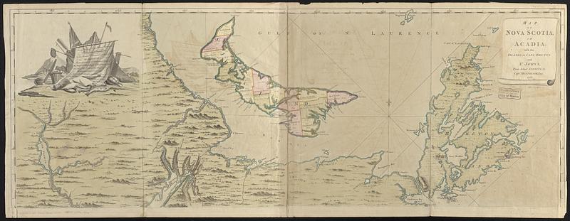
Map of Nova Scotia, or Acadia : with the islands of Cape Breton and St. John's, from actual surveys

This map is also available in American Revolutionary Geographies Online (ARGO), a collections portal especially built for material relating to the American Revolutionary War Era. Visit ARGO to learn more about this item and explore the historical geography of North America in the late eighteenth century.
Item Information
- Title:
- Map of Nova Scotia, or Acadia : with the islands of Cape Breton and St. John's, from actual surveys
- Engraver:
- Caldwall, James, 1739-1819
- Printer:
- Dury, Andrew
- Dedicatee:
- Granby, John Manners, Marquis of, 1721-1770
- Cartographer:
- Montrésor, John, 1736-1799
- Name on Item:
-
by Captn. Montresor, engir. 1768
- Date:
-
1768
- Format:
-
Maps/Atlases
- Location:
-
Boston Public Library
Norman B. Leventhal Map & Education Center - Collection (local):
-
Norman B. Leventhal Map & Education Center Collection
- Subjects:
-
Nova Scotia--Maps--Early works to 1800
Acadia--Maps--Early works to 1800
Prince Edward Island--Maps--Early works to 1800
Prince Edward Island--Administrative and political divisions--Maps--Early works to 1800
Cape Breton Island (N.S.)--Maps--Early works to 1800
- Places:
-
CanadaNova Scotia (province)
CanadaProvince of Prince Edward Island (province)
CanadaNova Scotia (province)Cape Breton Island (island)
- Extent:
- 1 map on 4 sheets : hand-colored, joined into 2 sheets ; 100 x 139 cm, sheets 54 x 141 cm
- Terms of Use:
-
No known copyright restrictions.
No known restrictions on use.
- Publisher:
-
London :
Printed & sold by A. Dury in Dukes Court St. Martins Lane
- Scale:
-
Scale approximately 1:390,000
- Language:
-
English
- Notes:
-
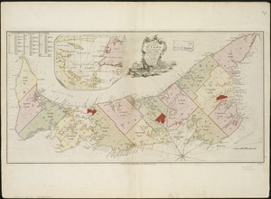
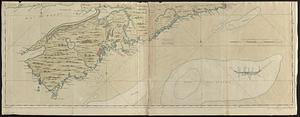
A map of Nova Scotia, Prince Edward Island and part of New Brunswick.
Relief shown pictorially and by hachures. Depths shown by soundings.
Prime meridians: London and Ferro.
Second state with parish divisions on St. John's Island.
Title in a decorative scroll surround at upper right.
Inscription to "John Manners" in decorative cartouche depicting fishing iconography.
Dedication reads: "To the most Noble John Manners Marquis of Granby, Field Marshal & Commander in Chief of all His Majesty's Forces Master General of the Ordnance, Colonel of His Majesty's Royal Regmt. of Horse Guards Blue and one of the Lords of His Majesty's most honourable Privy Council; This Map with all Submission is most humbly inscribed by Your Lordship's most dutiful most obedient, and devoted servant John Montresor, Engineer."
Also published in The North American Atlas, London, W. Faden, 1777.
- Notes (citation):
-
Kershaw, K.A. Early printed maps of Canada, 1703-1799, vol. 3, entry 793
Phillips, P.E. List of Maps of America in the Library of Congress, vol. 2, p. 624
Seller, J.R. Maps and charts of North America and the West Indies, 1750-1789, entry 312
- Identifier:
-
06_01_018272
- Call #:
-
G3420 1768 .M66
- Barcode:
-
39999085964912