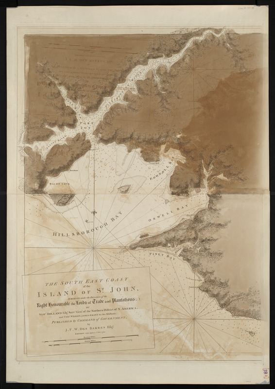
The south east coast of the island of St. John : surveyed under the direction of the Right Honourable the Lords of Trade and Plantations
This map is also available in American Revolutionary Geographies Online (ARGO), a collections portal especially built for material relating to the American Revolutionary War Era. Visit ARGO to learn more about this item and explore the historical geography of North America in the late eighteenth century.
Item Information
- Title:
- The south east coast of the island of St. John : surveyed under the direction of the Right Honourable the Lords of Trade and Plantations
- Creator:
- Des Barres, Joseph F. W. (Joseph Frederick Wallet), 1722-1824
- Name on Item:
-
by Saml. Holland, esqr.
- Date:
-
[1780]
- Format:
-
Maps/Atlases
- Location:
-
Boston Public Library
Norman B. Leventhal Map & Education Center - Collection (local):
-
Norman B. Leventhal Map & Education Center Collection
- Subjects:
-
Nautical charts--Prince Edward Island--Early works to 1800
Prince Edward Island--Maps--Early works to 1800
- Places:
-
CanadaProvince of Prince Edward Island (province)
- Extent:
- 1 chart ; 102 x 77 cm.
- Terms of Use:
-
No known copyright restrictions.
No known restrictions on use.
- Publisher:
-
London :
J.F.W. Des Barres
- Edition:
- 2nd state.
- Scale:
-
Scale [ca. 1:50,000]
- Language:
-
English
- Notes:
-
Relief shown by hachures and shading. Depths shown by soundings.
Appears in the author's Atlantic Neptune. London : J.F.W. Des Barres, 1777-[1781].
Western sheet only.
- Notes (date):
-
This date is inferred.
- Identifier:
-
06_01_004964
- Call #:
-
G1106.P5 D47 1777
- Barcode:
-
30000003805327

![[The south east coast of the island of St. John]](https://bpldcassets.blob.core.windows.net/derivatives/images/commonwealth:7h149v93n/image_thumbnail_300.jpg)


