Toggle navigation
LMEC Home
Exhibitions
Georeferencing
Tools for Teachers
Collections
My Favorites
Sign Up / Log In
Search
Search the map portal
Map Collection
Map Collection
Map Sets
Search
Search
Search for
Search In
All Fields
Creator
Title
Subject
Place
Search All Digital Collections
Advanced Search
311 Results
My Search
Start Over
More Like
commonwealth:3f462v674
Remove constraint More Like: commonwealth:3f462v674
Filter your Search
Place
North and Central America
232
North America
170
United States
138
Massachusetts
72
Boston
44
Suffolk (county)
43
New England
34
Boston Harbor
29
more
Place
»
Topic
North America--Maps--Early works to 1800
180
New England--Maps--Early works to 1800
27
Boston (Mass.)--Maps
20
World maps--Early works to 1800
19
Boston (Mass.)--History--Revolution, 1775-1783--Maps--Early works to 1800
16
Great Britain--Colonies--America--Maps--Early works to 1800
15
United States--Maps--Early works to 1800
14
Boston Harbor (Mass.)--Maps--Early works to 1800
13
more
Topic
»
Date
Date range begin
–
Date range end
Current results range from
1493
to
1927
View distribution
Creator
Mitchell, John, 1711-1768
13
Jefferys, Thomas, -1771
11
Moll, Herman, d. 1732
11
Sayer, Robert, 1725-1794
10
Anville, Jean Baptiste Bourguignon d', 1697-1782
8
Page, Thomas Hyde, Sir, 1746-1821
7
Bellin, Jacques Nicolas, 1703-1772
6
United States Coast Survey
6
more
Creator
»
Format
Maps/Atlases
310
Manuscripts
2
Prints
1
Georeferenced
Yes
30
No
281
Collection
Norman B. Leventhal Map & Education Center Collection
242
American Revolutionary War-Era Maps
151
Mapping Boston Collection
139
Boston and New England Maps
75
New York Public Library Collection
32
Maritime Charts and Atlases
28
Urban Maps
23
Richard H. Brown Revolutionary War Map Collection at Mount Vernon
18
more
Collection
»
Available to use
Creative Commons license
192
No known restrictions
108
Search Constraints
Sort by date (desc)
relevance
title
date (asc)
date (desc)
Number of results to display per page
50 per page
10
per page
20
per page
50
per page
100
per page
View results as:
grid view
map view
Search Results
101.
An Accurate map of the present seat of war between Great-Britain and her colonies in North America
102.
Acurate charte von Nord-America : aus dem besten quellen
103.
L'Amérique Septentrionale
104.
Bowles's new pocket map of the most inhabited part of New England : comprehending the provinces of Massachusets Bay and New...
105.
Carte du port et havre de Boston avec les côtes adjacentes, dans laquel on a tracée les camps et les retranchemens occupé,...
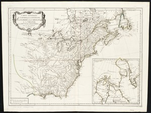
106.
Carte générale du Canada, de la Louisiane, de la Floride, de la Caroline, de la Virginie, de la Nouvelle Angleterre etc
107.
Carte nouvelle de l'Amérique Angloise contenant tout ce que les Anglois possédent sur le continent de l'Amérique...
108.
Carte von dem Hafen und der Stadt Boston : mit den umliegenden Gegenden und der Lägern sowohl der Americaner als auch des...
109.
A chart of Boston Bay and vicinity
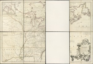
110.
Partie de l'Amerique Septentrionale, qui comprend le Canada, la Louisiane, le Labrador, le Groenland, la Nouvelle Angleterre,...
111.
A plan of Boston, and its environs : shewing the true situation of His Majesty's army, and also those of the rebels
112.
An accurate map of North America : Describing and distinguishing the British and Spanish dominions of this great continent;...
113.
An accurate map of North America : describing and distinguishing the British and Spanish dominions of this great continent;...
114.
Exact plan of General Gage's lines on Boston Neck in America
115.
A map of the British colonies in North America : with the roads, distances, limits, and extent of the settlements, humbly...
116.
A MAP of the BRITISH COLONIES in North America : WITH THE Roads, Distances, Limits, and Extent of the SETTLEMENTS, Humbly...
117.
A map of the British colonies in North America : with the roads, distances, limits, and extent of the settlements, humbly...
118.
A map of the British Empire in America with the French and Spanish settlements adjacent thereto
119.
Map of the environs of Boston
120.
A new and correct plan of the town of Boston
121.
Plan of the battle, on Bunker's Hill : fought on the 17th of June 1775
122.
A plan of the town and chart of the harbour of Boston exhibiting a view of the islands, castle forts, and entrances into the...
123.
A sketch of the action between the British forces and the American provincials, on the heights of the peninsula of Charlestown,...
124.
The able doctor; or America swallowing the bitter draught
125.
A map of the most inhabited part of New England : containing the provinces of Massachusets Bay and New Hampshire, with the...
126.
North America : performed under the patronage of Louis Duke of Orleans, First Prince of the Blood
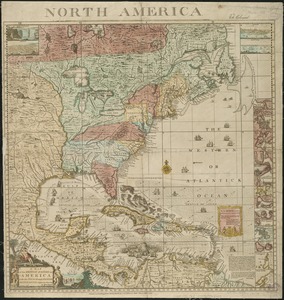
127.
North America
128.
North America, agreeable to the most approved maps and charts
129.
North America, as divided amongst the European powers
130.
An accurate map of North America : describing and distinguishing the British and Spanish dominions on this great continent :...
131.
An exact map of North America : from the best authorities
132.
North America
133.
An accurate map of North America : describing and distinguishing the British, Spanish and French dominions on this great...
134.
Chart of the Atlantic Ocean, with the British, French, & Spanish settlements in North America, and the West Indies : as also on...
135.
A map of the discoveries made by the Russians on the North West coast of America
136.
A map of the n.e. part of Asia, and n.w. parts of America, shewing their situations with respect to Japan
137.
A new and accurate map of North America
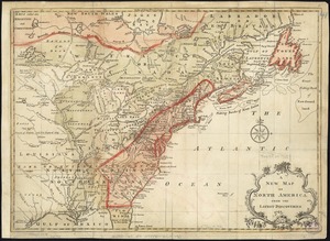
138.
North America : from the French of Mr. d'Anville, improved with the back settlements of Virginia and course of Ohio,...
139.
A new and correct chart of the sea coast of New-England from Cape Codd to Casco Bay
140.
North America
141.
Carte de la Baye de Baston : située dans la Nouvelle Angleterre
142.
Plan de la ville de Boston
143.
Plan de la ville et du port de Boston : capitale de la Nouvelle Angleterre : erigée prémierement en 1630, et en 1735 elle fut...
144.
Plan de la ville et du port de Boston : capitale de la Nouvelle Angleterre
145.
A map of North America, & the West India Islands, with part of South America, Europe, Africa & the Atlantic Ocean with it's...
146.
A new and accurate map of North America : laid down according to the latest, and most approved observations and discoveries
147.
A new and accurate map of North America : laid down according to the latest, and most approved observations and discoveries
148.
A new map of North America : with the British, French, Spanish, Dutch & Danish dominions on that great continent, and the West...
149.
A new map of North America from the latest discoveries
150.
A new map of North America wherein the British Dominions in the continent of North America : and on the islands of the West...
‹ Prev
Next ›
1
2
3
4
5
6
7