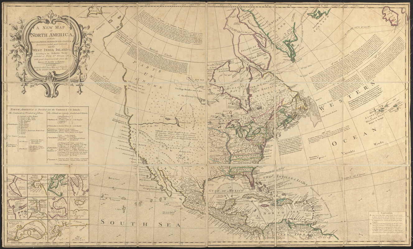
A new map of North America : with the British, French, Spanish, Dutch & Danish dominions on that great continent, and the West India Islands, according to the definitive treaty concluded at Paris 10th February 1763
This map is also available in American Revolutionary Geographies Online (ARGO), a collections portal especially built for material relating to the American Revolutionary War Era. Visit ARGO to learn more about this item and explore the historical geography of North America in the late eighteenth century.
Item Information
- Title:
- A new map of North America : with the British, French, Spanish, Dutch & Danish dominions on that great continent, and the West India Islands, according to the definitive treaty concluded at Paris 10th February 1763
- Publisher:
- Sayer, Robert, 1725-1794
- Cartographer:
- Anville, Jean Baptiste Bourguignon d', 1697-1782
- Cartographer:
- Robert de Vaugondy, Didier, 1723-1786
- Name on Item:
-
with great improvements from the Sieurs d'Anville & Robert
- Date:
-
[1763?]
- Format:
-
Maps/Atlases
- Location:
-
Boston Public Library
Norman B. Leventhal Map & Education Center - Collection (local):
-
Norman B. Leventhal Map & Education Center Collection
- Subjects:
-
North America--Maps--Early works to 1800
- Places:
-
North America (area)
- Extent:
- 1 map : hand-colored ; 56 x 93 cm
- Terms of Use:
-
No known copyright restrictions.
No known restrictions on use.
- Publisher:
-
London :
Printed for Robt. Sayer
- Scale:
-
Scale approximately 1:18,000,000
- Language:
-
English
- Notes:
-
Relief shown pictorially.
Includes historical notes, treaty extracts, prevailing wind directions, 10 insets of harbors, and a table showing that "North America is divided into the continent & the islands" according to geography and politics.
Inset maps: St. John's Harbour -- Boston Harbour -- P. of Long Island -- Ashley and Cooper River -- Port Royal Harbour -- Bay and city of Havana -- Bay of Porto Bella -- La Vera Cruz -- Cartagena Harbour and forts -- The part of Acapulco.
- Identifier:
-
06_01_012682
- Call #:
-
G3300 1763 .S29
- Barcode:
-
39999065698878


