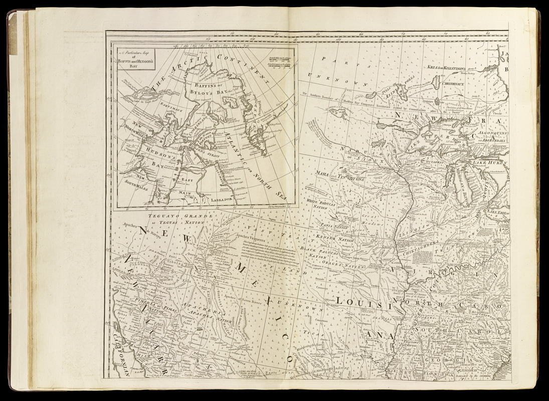
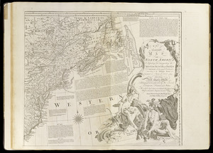
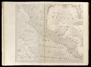
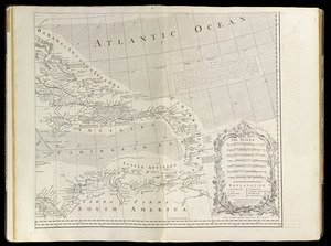
An accurate map of North America : describing and distinguishing the British, Spanish and French dominions on this great continent : according to the definitive treaty concluded at Paris 10th Feb. 1763 : also all the West India Islands belonging to, and possessed by the several European princes and states

This map is also available in American Revolutionary Geographies Online (ARGO), a collections portal especially built for material relating to the American Revolutionary War Era. Visit ARGO to learn more about this item and explore the historical geography of North America in the late eighteenth century.
Item Information
- Title:
- An accurate map of North America : describing and distinguishing the British, Spanish and French dominions on this great continent : according to the definitive treaty concluded at Paris 10th Feb. 1763 : also all the West India Islands belonging to, and possessed by the several European princes and states
- Cartographer:
- Bowen, Emanuel, 1693 or 1694-1767
- Publisher:
- Sayer, Robert, 1725-1794
- Engraver:
- Gibson, J. (John), active 1750-1792
- Publisher:
- Jefferys, Thomas, -1771
- Name on Item:
-
the whole laid down according to the latest and most authentick improvements by Eman. Bowen ... and John Gibson engraver
- Date:
-
[1768]
- Format:
-
Maps/Atlases
- Location:
-
Boston Public Library
Norman B. Leventhal Map & Education Center - Collection (local):
-
Norman B. Leventhal Map & Education Center Collection
- Subjects:
-
North America--Maps--Early works to 1800
- Places:
-
North America (area)
- Extent:
- 1 map on 4 sheets ; sheets 51 x 57 cm.
- Terms of Use:
-
No known copyright restrictions.
No known restrictions on use.
- Publisher:
-
London :
Printed for Robt. Sayer opposite Fetter Lane Fleet Street
- Scale:
-
Scale [1:5,500,000]
- Language:
-
English
- Notes:
-
Relief shown pictorially.
Inset maps: "The passage by land to California ..." and "A particular map of Baffin and Hudsons Bay."
Shows boundaries, rivers, shoals roads, forests and settlements ; articles from the Treaty ; notes about the region ; arrows show prevailing wind direction.
Appears in Thomas Jefferys' General topography of North America and the West Indies. London: Printed for Robert Sayer, 1768.
- Notes (date):
-
This date is inferred.
- Identifier:
-
4000137_0015
4000137_0016
4000137_0017
4000137_0018
- Call #:
-
G1105 .J4 1768
- Barcode:
-
30000003761149


