North America : performed under the patronage of Louis Duke of Orleans, First Prince of the Blood

This map is also available in American Revolutionary Geographies Online (ARGO), a collections portal especially built for material relating to the American Revolutionary War Era. Visit ARGO to learn more about this item and explore the historical geography of North America in the late eighteenth century.
Item Information
- Title:
- North America : performed under the patronage of Louis Duke of Orleans, First Prince of the Blood
- Cartographer:
- Bolton, Solomon, -approximately 1768
- Cartographer:
- Anville, Jean Baptiste Bourguignon d', 1697-1782
- Engraver:
- Seale, Richard William
- Engraver:
- Walker, Anthony, 1726-1765
- Contributor:
- Postlethwayt, Malachy, 1707?-1767
- Engraver:
- Gravelot, Hubert François, 1699-1773
- Name on Item:
-
by the Sieur d'Anville ; greatly improved by Mr. Bolton ; engrav'd by R. W. Seale ; Gravelot, delin. ; Walker sculp.
- Date:
-
[1774]
- Format:
-
Maps/Atlases
- Location:
-
Boston Public Library
Norman B. Leventhal Map & Education Center - Collection (local):
-
Norman B. Leventhal Map & Education Center Collection
- Subjects:
-
North America--Maps--Early works to 1800
- Places:
-
North America (area)
- Extent:
- 1 map on 4 sheets ; 83 x 87 cm, on sheets 59 x 70 cm and 54 x 44 cm
- Terms of Use:
-
No known copyright restrictions.
No known restrictions on use.
- Publisher:
-
[London] :
[Printed for W. Strahan, J. and F. Rivington, J. Hinton [and others]]
- Scale:
-
Scale approximately 1:6,250,000
- Language:
-
English
- Table of Contents:
-
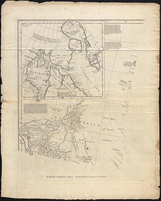
North America, plate I
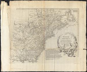
pl. II
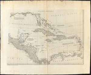
North America, plate III
Part of North America, plate IV
- Notes:
-
Relief shown pictorially.
Prime meridian: Ferro.
Shows provinces, cities and towns, forts, Indian villages and tribal territory.
Also shows shoals, banks, and other navigational hazards off the coast of Nova Scotia and in the Caribbean area.
From The universal dictionary of trade and commerce volume II / by Malachy Postlethwayt. 4th edition. London : Printed for W. Strahan, J. and F. Rivington, J. Hinton [and others], 1774.
Includes inset of northeastern Canada, historical and descriptive notes, and text "Pursuant to the last Treaty of Peace concluded at Paris, Feb. 10, 1763."
Statements for Mr. Postlethwayt's Dictionary of trade & commerce at bottom of plates.
Boston Public Library lacking plate III.
Note about maps for Mr. Postlethwayt's Dictionary of commerce in decorative cartouche in lower left.
Decorative title cartouche depicting a Native American woman, two children and flora and fauna of North America.
- Notes (date):
-
This date is inferred.
- Identifier:
-
06_01_017822A
06_01_017822B
06_01_017822C
- Call #:
-
G3300 1774 .B65
- Barcode:
-
39999085963294


