Toggle navigation
LMEC Home
Exhibitions
Georeferencing
Tools for Teachers
Collections
My Favorites
Sign Up / Log In
Search
Search the map portal
Map Collection
Map Collection
Map Sets
Search
Search
Search for
Search In
All Fields
Creator
Title
Subject
Place
Search All Digital Collections
Advanced Search
13385 Results
Filter your Search
Place
North and Central America
9,353
United States
7,078
Suffolk (county)
1,664
Boston
1,621
Europe
1,035
Canada
949
Massachusetts
794
New York
532
more
Place
»
Topic
Boston (Mass.)--Maps
741
City planning--Massachusetts--Boston--Maps
418
United States--History--Revolution, 1775-1783--Maps
329
United States--Maps
315
Urban renewal--Massachusetts--Boston--Maps
254
Real property--Massachusetts--Boston--Maps
252
Massachusetts--Maps
219
Insurance surveys
197
more
Topic
»
Date
Date range begin
–
Date range end
Current results range from
1482
to
2023
View distribution
Creator
United States. Hydrographic Office
595
Boston Redevelopment Authority
403
Des Barres, Joseph F. W. (Joseph Frederick Wallet), 1722-1824
247
Royal United Services Institute for Defence and Security Studies
160
Jefferys, Thomas, -1771
154
George, III, King of Great Britain, 1738-1820
152
George, IV, King of Great Britain, 1762-1830
151
O.H. Bailey & Co
148
more
Creator
»
Format
Maps/Atlases
13,205
Manuscripts
985
Prints
102
Books
49
Drawings/Illustrations
44
Photographs
15
Objects/Artifacts
13
Documents
7
more
Format
»
Georeferenced
Yes
979
No
12,406
Collection
Norman B. Leventhal Map Center Collection
8,891
American Revolutionary War-Era Maps
3,305
Boston and New England Maps
2,804
Urban Maps
2,397
Maritime Charts and Atlases
1,150
William L. Clements Library Collection
910
Library of Congress Collection
618
Boston Redevelopment Authority Collection
475
more
Collection
»
Available to use
No known restrictions
9,952
Creative Commons license
1,677
Search Constraints
Sort by relevance
relevance
title
date (asc)
date (desc)
Number of results to display per page
100 per page
10
per page
20
per page
50
per page
100
per page
View results as:
grid view
map view
Search Results
11301.
The seat of war in New England, by an American volunteer : with the marches of the several corps sent by the Colonies towards...
11302.
Seat of war in Tennesse and Georgia : 6D
11303.
The seat of war in the circle of Westphalia
11304.
Seat of war in the east : map of Turkey and parts adjacent
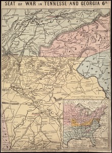
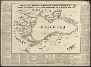
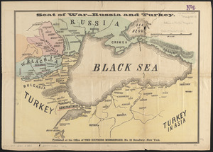
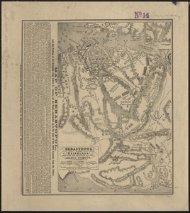
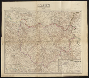
11305.
Seat of war in the east
11306.
Seat of war in the east : map of Turkey and parts adjacent
11307.
Seat of war in the environs of Philadeliphia
11308.
Seat of war in the environs of Philadeliphia
11309.
Seat of war in the environs of Philadelphia
11310.
Seat of war in the environs of Philadelphia
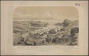
11311.
Seat of war in Virginia
11312.
Seat of war in Virginia and Maryland
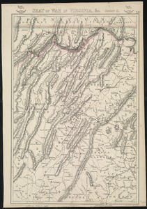
11313.
Seat of war in Virginia, &c
11314.
The seat of war in ye North : or a map of the Baltick, with part of the North Sea ... posture of affaris
11315.
The seat of war in ye North : or a map of the Baltick, with part of the North Sea ... posture of affaris
11316.
Seat of war on the Rhine and Moselle
11317.
The seat of war on the Rhine being a new map of the course of that river from Basil to Bonn with the adjacent countries
11318.
Seat of war--Russia and Turkey
11319.
Seat of war--Russia and Turkey
11320.
Sebastopol and Balaklava shewing the position of the allied forces
11321.
Sebastopol, and fortifications now in active progress on the land side
11322.
Second part of Asia : being China, part of India and Tartary, the islands of Sonda, Molucka, Philippin, Japan &c. ; performed...
11323.
The second section of the survey of 1819
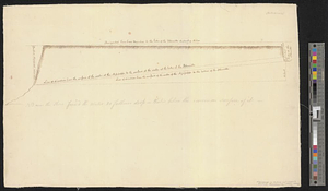
11324.
Seconnet Passage
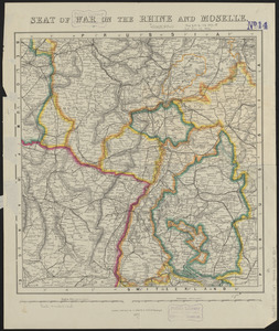
11325.
Sect: Düsseldorf
11326.
Section 16: Chemnitz
11327.
Section 16: Chemnitz
11328.
Section of a track chart of the world, covering the Behring Sea
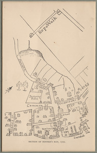
11329.
Section of Bonner's map
11330.
Section of the Citadel-Hill at Halifax : Showing the Progress made by the troops in leveling the same upon the line of 40 feet...
11331.
Section of the level of the country
11332.
Section taken from the nearest Commanding Ground thro' the Center of the TOWER to High Water Mark
11333.
Sectional & topographical map of Holmes County, Ohio
11334.
A sectional map of Massachusetts, engraved expressly for Chapin's farm advertiser, 1871 : including the proposed Massachusetts...
11335.
Sectional map of the northern portion of Vancouver Island
11336.
Sectional map of the Old Colony Railroad South Shore, Nantasket Beach and Plymouth lines
11337.
Sections of soundings made by order of the Harbor Committee of 1852
11338.
Secunda Affrice tabula continet Affricam & insulae que circa ipsam sunt
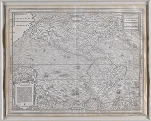
11339.
Secunda Africae tabula
11340.
Secunda Asiae tabula
11341.
Secunda Asie tabula continet Sarmatia ipsius
11342.
Secunda etas mundi = Secunda etas mũdi
11343.
Secunda etas mundi = Secunda etas mũdi
11344.
Secunda Europae tabula
11345.
Secunda Europe tabula
11346.
Segusiani : partie du dioecese et archevesche de Lyon : Le Bas Forez et Beaujolois : eslectons de Roanne et de Villefranche
11347.
Segusiani : partie du dioese et archevche de Lyon : le Lyonnois et le haut forez : eslections de Lyon, de St. Chamont, et de...
11348.
Selected hurricanes affecting the southern United States 1954-1977
11349.
Senones : Evesché d'Auxerre : Comté et Ballge d'Auxerre : Eslectons. de Clamecy, de Gien, de la Charité, et de Vezelay
11350.
Septentrion, quarte partie du monde
11351.
Septentrionalium terrarum descriptio
11352.
Septentrionalium terrarum descriptio
11353.
Septima Asia tabula continet Margianam, Bactrianam, Sogdianos, Sacas & Scythiam intra Imaū mōtē
11354.
Septima Asiae tabula
11355.
Septima Europa tabula continet Sardininiam & Sicilia insulas
11356.
Septima Europae tabula
11357.
Ser. Reg. Caroli Gustavi victoriolus e Sialandia disccssus facta pace Rothschildenli d. 5 Martij 1658 ; Ser. Reg. Sueciæ...
11358.
Serbien : nach Österreichischen und Russischen aufnahmen und ortsbestimmungen, und den karten von Viquesnel und Bugarski
11359.
Serio-comic war map for the year 1877
11360.
Al sermo. Ferdinando. II. Grandvca di Toscana svo signore Don Roberto Dudleo, Duca di Northumbria
11361.
The Seven Islands and the Bay
11362.
Seven miles around Jerusalem : from original surveys and observations
11363.
The Seven United Provinces of Holland, Groningen, Gelders, Friesland, Overyssel, Utrecht and Zealand : from the best authorities
11364.
The Seven United Provinces of Netherland : with its circumjacent borders
11365.
The seven United Provinces, with their roads and divisions
11366.
The Seventh Ward of Philadelphia : the distribution of Negro inhabitants throughout the ward, and their social conditions
11367.
Sewerage division map city of Cambridge
11368.
Sexta Asiae tabula
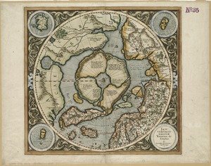
11369.
Sexta Asie tabula continet Arabiam, Felice atq[ue] Carmania cu adiacentibus insulis
11370.
Sexta Europa tabula continet Italiam
11371.
Sexta Europae tabula
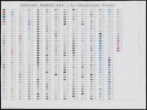
11372.
Shaded relief map of the Aeolis quadrangle of Mars : MC-23, M 5M-15/202 RN
11373.
Shadesets
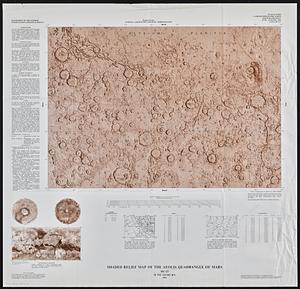
11374.
Shadow analysis
11375.
Shah Bay, Loo Choo I.
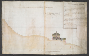
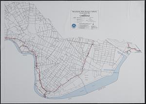
11376.
Shaker Village
11377.
Shall Union Square overshadow the United States? : America's other 60 families : the real rulers of America
11378.
Shamokin : Pennsylvania, 1884
11379.
A shared problem, an unequal burden : causes & consequences of climate change
11380.
Shawmut 1630--Boston 1930 : three hundred years of progress
11381.
Shawmut 1630--Boston 1930 : three hundred years of progress
11382.
Shawmut Avenue
11383.
Sheboygan County, Wis.
11384.
The Sheffield Corporation, et al., Greenfield, Mass. [insurance map]
11385.
Shepherd's map of the seat of war
11386.
Sherman & Smith's rail road, steam boat & stage route map of New England, New-York, and Canada
11387.
Shewey's new map of the city of St. Louis
11388.
Shíjú tú
11389.
Shinsen zouho Kyo oezu
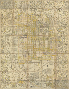
11390.
Shinsen zouho Kyo oezu
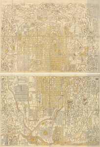
11391.
Shinsen zouho Kyo oezu
11392.
Shipyard Park phase 3 : Boston Naval Shipyard at Charlestown : schematic design
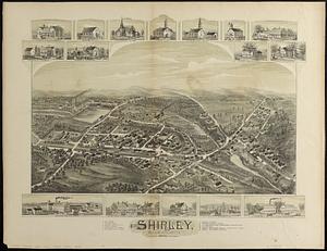
11393.
Shirley, Massachusetts, 1892
11394.
The Shoals of Beauport; The River St. Lawrence from the Basin of Quebec to the Falls of Richeu
11395.
Shoshone National Forest, Wyoming
11396.
Showing rental values in greater Tokyo - 1926
11397.
Siberia
11398.
Das Siebengebirge
11399.
Siege d'York, 1781 : Plan d'York en Virginie avec les attaques et les campemens de l'Armée combinée de France et d'Amérique
11400.
Siège d'York 1781 : carte des environs d'York en Virginie avec les attaques et la position des armées Françoise et Américaine...
‹ Prev
Next ›
1
2
…
110
111
112
113
114
115
116
117
118
…
133
134