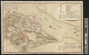
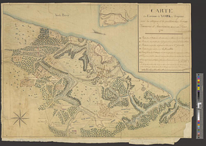
Siège d'York 1781 : carte des environs d'York en Virginie avec les attaques et la position des armées Françoise et Américaine pendant le siege en 8bre. 1781
This map is also available in American Revolutionary Geographies Online (ARGO), a collections portal especially built for material relating to the American Revolutionary War Era. Visit ARGO to learn more about this item and explore the historical geography of North America in the late eighteenth century.
Item Information
- Title:
- Siège d'York 1781 : carte des environs d'York en Virginie avec les attaques et la position des armées Françoise et Américaine pendant le siege en 8bre. 1781
- Creator:
- Bouan, Louis A. P.
- Date:
-
[1781]
- Format:
-
Maps/Atlases
- Genre:
-
Manuscript maps
- Location:
- William L. Clements Library
- Collection (local):
-
William L. Clements Library Collection
- Subjects:
-
Yorktown (Va.)--Maps
Yorktown (Va.)--History--Siege, 1781--Maps
United States--History--Revolution, 1775-1783--Maps
- Places:
-
VirginiaYork (county)Yorktown
- Extent:
- 1 ms. map : col. ; 46.5 x 49 cm
- Terms of Use:
-
The University of Michigan Library provides access to these materials for educational and research purposes. These materials may be under copyright. If you decide to use any of these materials, you are responsible for making your own legal assessment and securing any necessary permission. If you have questions about the collection, please contact the William L. Clements Library.
Contact host institution for more information.
- Scale:
-
Scale ca. 1:15,400.
- Language:
-
French
- Catalog Record:
-
Catalog record
- Notes:
-
Finished, colored, topographical map showing troop positions during the siege.
Table of references identifies positions of British ships and American and French entrenchments.
Includes ms. overlay 18.5 x 30.5 cm.
Authorship attributed to Bouan.
- Notes (date):
-
This date is inferred.
- Identifier:
-
8668
- Barcode:
-
B1937160