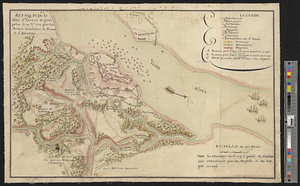
Amérique Septentrionale, Yorck : reconnoissance des ouvrages de cette ville ave le tracé des attaques dirigées contre eux

This map is also available in American Revolutionary Geographies Online (ARGO), a collections portal especially built for material relating to the American Revolutionary War Era. Visit ARGO to learn more about this item and explore the historical geography of North America in the late eighteenth century.
Item Information
- Title:
- Amérique Septentrionale, Yorck : reconnoissance des ouvrages de cette ville ave le tracé des attaques dirigées contre eux
- Date:
-
[ca. 1781]
- Format:
-
Maps/Atlases
- Genre:
-
Manuscript maps
- Location:
- William L. Clements Library
- Collection (local):
-
William L. Clements Library Collection
- Subjects:
-
Yorktown (Va.)--Maps
Yorktown (Va.)--History--Siege, 1781--Maps
United States--History--Revolution, 1775-1783--Maps
- Places:
-
VirginiaYork (county)Yorktown
- Extent:
- 1 ms. map : col. ; 63.5 x 75.1 cm.
- Terms of Use:
-
The University of Michigan Library provides access to these materials for educational and research purposes. These materials may be under copyright. If you decide to use any of these materials, you are responsible for making your own legal assessment and securing any necessary permission. If you have questions about the collection, please contact the William L. Clements Library.
Contact host institution for more information.
- Scale:
-
Scale of toises.
- Language:
-
French
- Catalog Record:
-
Catalog record
- Notes:
-
Finished, colored topographical map showing the defenses and siege lines during the siege of Yorktown.
A number of points on the map are identified in a table of references, which also gives a tabulation of the numbers of British troops captured at Yorktown.
- Identifier:
-
8663
- Barcode:
-
B2529580