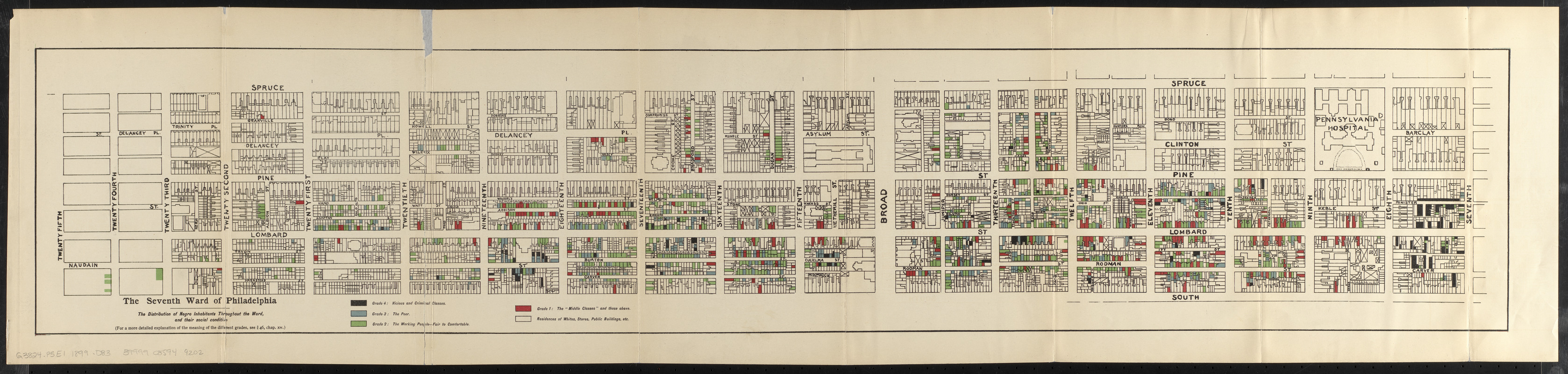
The Seventh Ward of Philadelphia : the distribution of Negro inhabitants throughout the ward, and their social conditions
Item Information
- Title:
- The Seventh Ward of Philadelphia : the distribution of Negro inhabitants throughout the ward, and their social conditions
- Description:
-
America Transformed: By the end of the century, Philadelphia was home to 40,000 African Americans, comprising the largest population of any northern city. Drawing from the sociological studies by residents of Chicago's Hull House, African American sociologist W. E. B. Du Bois undertook a similar study in Philadelphia, focusing on Ward 7, the location of the city's oldest Black neighborhood. In this community with roughly 9,700 residents, Du Bois and his associates conducted approximately 5,000 interviews. Their findings were published as The Philadelphia Negro (1899), which included this fold-out map with the location of every residence, church, and business owned by Black people.
America Transformed: Viewpoint: The disappearance of historic Black neighborhoods continues. At the end of the 19th century, Philadelphia's Seventh Ward was the heart of Black Philadelphia. Today, it is a trendy middle-class and white neighborhood. For those that walk these streets, several historic markers and a mural remind us of the Black life once etched into this landscape. Du Bois' maps disrupt the notion of Blacks as a monolithic group by visualizing a far more compelling story of class diversity. This was the place physician Dr. Nathan Mossell, business owner Robert Mara Adger, educators Octavius Catto and Fanny Jackson Coppin, activist Frances Allen Watkins, faith leader Rev. Henry Phillips, junk dealer Arthur McKenzie, waiter Oscar Stewart, dress-maker Bessie Corney, and about 40,000 other Blacks lived and/or worked alongside immigrants and whites. Mother Bethel African Methodist Episcopal Church still stands on the edge of this neighborhood. It remains the longest held Black property in the United States while also preserving Black religion, culture, and history. –Dr. Stephanie Clintonia Boddie, Baylor University, Diana R. Garland School of Social Work, George W. Truett Theological Seminary and School of Education.
- Cartographer:
- Du Bois, W. E. B. (William Edward Burghardt), 1868-1963
- Date:
-
[1899]
- Format:
-
Maps/Atlases
- Location:
-
Boston Public Library
Norman B. Leventhal Map & Education Center - Collection (local):
-
Norman B. Leventhal Map & Education Center Collection
- Subjects:
-
African Americans--Pennsylvania--Philadelphia--Maps
African Americans--Pennsylvania--Philadelphia--Social Conditions
Philadelphia (Pa.)--Social conditions
Philadelphia (Pa.)--Maps
- Places:
-
PennsylvaniaPhiladelphia (county)Philadelphia
- Extent:
- 1 map : color ; 21 x 105 cm
- Terms of Use:
-
No known copyright restrictions.
No known restrictions on use.
- Publisher:
-
[Philadelphia] :
[Published for the University]
- Scale:
-
Scale approximately 1:2,400
- Language:
-
English
- Notes:
-
Indicates vicious and criminal classes; the poor; the working people; and the "middle classes" and those above.
From The Philadelphia Negro / by W.E. Burghardt Du Bois. Philadelphia : Published for the University, 1899.
- Notes (date):
-
This date is inferred.
- Notes (exhibitions):
-
Exhibited: "America transformed. Part 2: homesteads to modern cities," organized by the Norman B. Leventhal Map & Education Center at the Boston Public Library, 2019-2020.
- Identifier:
-
06_01_016815
- Call #:
-
G3824.P5E1 1899 .D83
- Barcode:
-
39999085949202