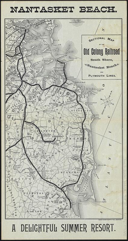
Sectional map of the Old Colony Railroad South Shore, Nantasket Beach and Plymouth lines
Item Information
- Title:
- Sectional map of the Old Colony Railroad South Shore, Nantasket Beach and Plymouth lines
- Title (alt.):
-
Nantasket Beach
Nantasket Beach via Old Colony R.R. : operating the Nantasket Beach Railroad : season of 1890
- Publisher:
- Rand Avery Supply Co.
- Date:
-
1890
- Format:
-
Maps/Atlases
- Location:
-
Boston Public Library
Norman B. Leventhal Map & Education Center - Collection (local):
-
Norman B. Leventhal Map & Education Center Collection
- Subjects:
-
South Shore (Mass. : Coast)--Maps
Railroads--Massachusetts--South Shore (Coast)--Maps
Old Colony Railroad Company
- Places:
-
MassachusettsNorfolk (county)
MassachusettsPlymouth (county)
- Extent:
- 1 map ; 31 x 18 cm, on sheet 37 x 20 cm, folded to 20 x 10 cm
- Terms of Use:
-
No known copyright restrictions.
No known restrictions on use.
- Publisher:
-
Boston :
Rand Avery Supply Co.
- Scale:
-
Scale approximately 1:190,000
- Language:
-
English
- Notes:
-
Oriented with north to the upper right.
Relief shown by hachures.
Tourist and railroad information on verso.
- Identifier:
-
06_01_017154
- Call #:
-
G3762.S62P3 1890 .R36
- Barcode:
-
39999085955795


