Historic Massachusetts : a travel map to help you feel at home in the Bay State


Item Information
- Title:
- Historic Massachusetts : a travel map to help you feel at home in the Bay State
- Title (alt.):
-
World of fun and relaxation - Massachusetts, the historic vacationland : a travel map to help you feel at home in the Bay State!
- Issuing body:
- Massachusetts. Department of Commerce and Development
- Cartographer:
- Chase, Ernest Dudley, 1878-1966
- Name on Item:
-
designed and drawn by Ernest Dudley Chase
- Date:
-
[1961]
- Format:
-
Maps/Atlases
- Genre:
-
Pictorial maps
Tourist maps
- Location:
-
Boston Public Library
Norman B. Leventhal Map & Education Center - Collection (local):
-
Norman B. Leventhal Map & Education Center Collection
- Subjects:
-
Massachusetts--Maps
North Shore (Mass. : Coast)--Maps
Boston (Mass.)--History--Maps
Berkshire Hills (Mass.)--Maps
Mohawk Trail (Mass.)--Maps
Pioneer Valley (Mass.)--Maps
South Shore (Mass. : Coast)--Maps
Cape Cod (Mass.)--Maps
Martha's Vineyard (Mass.)--Maps
Nantucket (Mass.)--Maps
Beaches--Massachusetts--Maps
- Places:
-
Massachusetts
- Extent:
- 1 map : color ; 51 x 81 cm, on sheet 55 x 87 cm, folded to 14 x 22 cm
- Terms of Use:
-
No known copyright restrictions.
No known restrictions on use.
- Publisher:
-
Boston, Massachusetts :
Massachusetts Department of Commerce
- Scale:
-
Scale approximately 1:370,000
- Language:
-
English
- Notes:
-
"Form 97, 50M-10-61-931540."
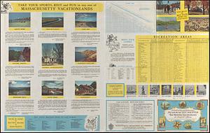
Pictorial tourist map.
Includes notes, illustrations, pictorial index to points of interest, and inset of "Greater Boston."
Mileage chart, recreation area table, vacationlands, list of state beaches open to the public, list of covered bridges, text, and illustrations on verso.
- Notes (date):
-
This date is inferred.
- Identifier:
-
06_01_017117A
06_01_017117B
- Call #:
-
G3761.E635 1961 .C53
- Barcode:
-
39999085954426


