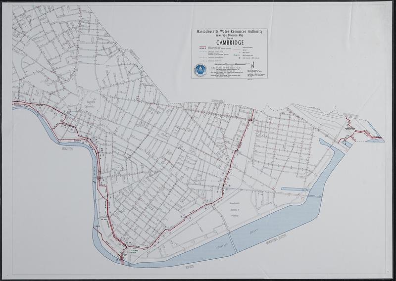
Sewerage division map city of Cambridge
Item Information
- Title:
- Sewerage division map city of Cambridge
- Cartographer:
- Applied Geographics, Inc.
- Publisher:
- Massachusetts Water Resources Authority
- Name on Item:
-
Massachusetts Water Resources Authority ; maps & data prepared by Applied Geographics, Inc., Boston in association with Camp Dresser & McKee, Inc., Cambridge, CDW Consultants, Inc., Framingham
- Date:
-
1993
- Format:
-
Maps/Atlases
- Location:
-
Boston Public Library
Norman B. Leventhal Map & Education Center - Collection (local):
-
Applied Geographics, Inc. Records
- Subjects:
-
Cambridge (Mass.)--Maps
Sewerage--Massachusetts--Cambridge--Maps
- Places:
-
MassachusettsMiddlesex (county)Cambridge
- Extent:
- 1 map : color, plastic-coated ; 84 x 117 cm
- Terms of Use:
-
No known copyright restrictions.
No known restrictions on use.
- Publisher:
-
Boston :
Massachusetts Water Resources Authority
- Scale:
-
Scale 1:4,800
- Language:
-
English
- Notes:
-
Shows interceptor pipes, sewers, storm drains, MWRA structures, MWRA meters, and public connections to MWRA interceptor.
"Sheet 2 of 2."
- Identifier:
-
06_01_018939
- Call #:
-
AppGeo Folder 4 no. 6
- Barcode:
-
30000008056783