Secunda etas mundi = Secunda etas mũdi
Item Information
- Title:
- Secunda etas mundi = Secunda etas mũdi
- Title (alt.):
-
World map
- Description:
-
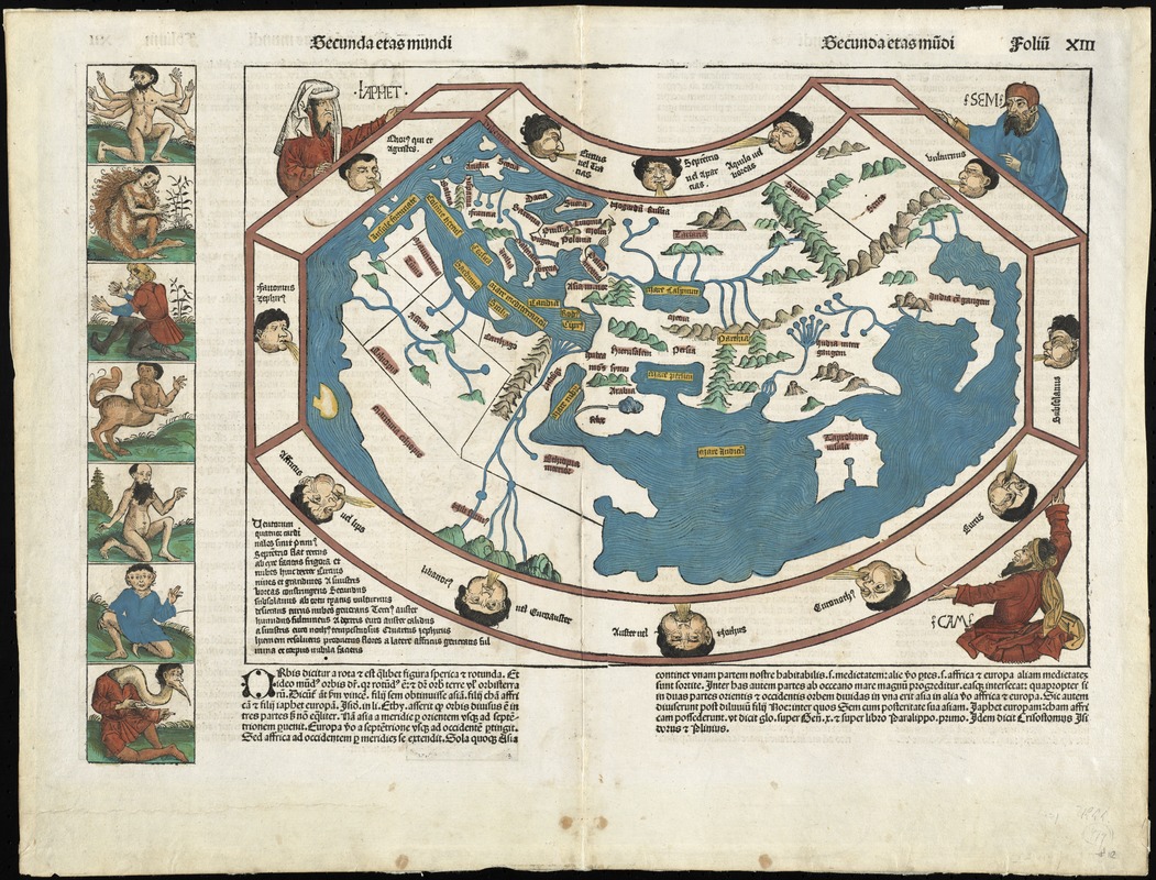
Although published just as news of Christopher Columbus's discoveries was beginning to spread, this was the last noteworthy world map to be produced without any indication of the New World. This depiction of the Old World was fanciful, and unlike earlier Ptolemaic maps, contained little detail. The text and wood cut illustrations, including this world map, which appeared in the Nuremberg Chronicle, were an amalgam of legend, fancy, and tradition interspersed with occasional scientific fact. For example the world map is supported by three biblical figures -- Ham, Shem, and Japhet -- while the marginal panel consists of exotic figures believed to exist in foreign lands.
- Creator:
- Schedel, Hartmann, 1440-1514
- Contributor:
- Koberger, Anton, approximately 1440-1513
- Contributor:
- Pleydenwurff, Wilhelm, -1494
- Contributor:
- Wolgemut, Michael, 1434-1519
- Name on Item:
-
[Hartmann Schedel]
- Date:
-
[July 12, 1493]
- Format:
-
Maps/Atlases
- Location:
- Phillips Academy
- Collection (local):
-
Sidney R. Knafel Map Collection at Phillips Academy, Andover MA
- Subjects:
-
World maps--Early works to 1800
Chronology, Historical--Maps--Early works to 1800
- Extent:
- 1 map ; 31 x 44 cm., on sheet 41 x 58 cm.
- Terms of Use:
-
Rights status not evaluated.
Contact host institution for more information.
- Publisher:
-
[Nuremberg] :
[Anton Koberger]
- Scale:
-
Scale not given
- Language:
-
Latin
- Notes:
-
Caption title.
Relief shown pictorially.
Wood engravings by Michael Wolgemut and Wilhelm Pleydenwurrf.
Upper right: "foliũ XIII."
From: Liber chronicarum, 12 July 1493.
Depicts the pre-Columbus world, based on Ptolemy's Geographia.
Jerusalem is at the center of the map; the Indian Ocean is an enclosed area; and Scandinavia, southern Africa and the Far East are not shown.
Eastern hemisphere (Known world).
Twelve winds, depicted as heads surrounding the map, are named as well as major places.
On verso: three columns of Latin text with the third column bordered by a panel of seven creatures on either side; upper right: "folium XII."
Appears in: Ptolemy, 2nd cent. Geographia
- Notes (date):
-
This date is inferred.
- Notes (citation):
-
Shirley, R.W. Mapping of the world, 19
- Notes (object):
-
Colored
- Identifier:
-
1422


