Toggle navigation
LMEC Home
Exhibitions
Georeferencing
Tools for Teachers
Collections
My Favorites
Sign Up / Log In
Search
Search the map portal
Map Collection
Map Collection
Map Sets
Search
Search
Search for
Search In
All Fields
Creator
Title
Subject
Place
Search All Digital Collections
Advanced Search
8394 Results
My Search
Start Over
More Like
commonwealth:m900r859c
Remove constraint More Like: commonwealth:m900r859c
Filter your Search
Place
North and Central America
5,143
United States
3,973
Suffolk (county)
1,253
Boston
1,226
Europe
963
Canada
427
Massachusetts
334
France
269
more
Place
»
Topic
Boston (Mass.)--Maps
741
United States--Maps
270
Real property--Massachusetts--Boston--Maps
252
City planning--Massachusetts--Boston--Maps
189
Landowners--Massachusetts--Boston--Maps
169
Massachusetts--Maps
163
North America--Maps--Early works to 1800
103
New England--Maps
101
more
Topic
»
Date
Date range begin
–
Date range end
Current results range from
1482
to
2023
View distribution
Creator
United States. Hydrographic Office
357
Boston Redevelopment Authority
191
O.H. Bailey & Co
148
Des Barres, Joseph F. W. (Joseph Frederick Wallet), 1722-1824
124
United States. Post Office Dept
120
Ptolemy, 2nd cent
100
Walling, Henry Francis, 1825-1888
94
Bromley, George Washington
86
more
Creator
»
Format
Maps/Atlases
8,335
Manuscripts
215
Prints
51
Books
36
Objects/Artifacts
10
Drawings/Illustrations
8
Posters
4
Georeferenced
Yes
885
No
7,509
Collection
Norman B. Leventhal Map Center Collection
8,192
Boston and New England Maps
2,347
Urban Maps
2,082
Maritime Charts and Atlases
750
American Revolutionary War-Era Maps
638
Boston Redevelopment Authority Collection
228
Massachusetts Real Estate Atlases
38
Mapping Boston Collection
20
more
Collection
»
Available to use
No known restrictions
8,172
Creative Commons license
69
Search Constraints
Sort by relevance
relevance
title
date (asc)
date (desc)
Number of results to display per page
100 per page
10
per page
20
per page
50
per page
100
per page
View results as:
grid view
map view
Search Results
8101.
A view of the Rivers Kenebec and Chaudiere, with Colonel Arnold's route to Quebec
8102.
View of the South End
8103.
A view of the taking of Quebeck by the English forces commanded by Gen. Wolfe Sep. 13th 1759
8104.
View of Thompsonville, Conn : 1878
8105.
View of Unionville, Conn : 1878
8106.
View of Wakefield, Mass : 1882
8107.
View of Wallingford, Connecticut : 1881
8108.
View of Waltham, Mass
8109.
View of Warren, Mass : 1879
8110.
View of Warren, R.I : 1877
8111.
View of Watertown, Mass : 1879
8112.
View of Webster, Mass : 1878
8113.
View of Westerly, R.I : 1877
8114.
View of Westport, Conn : 1878
8115.
View of Whitman and Brockton, showing location of some of the most desirable building lots, for sale by W.V. Everson, 120...
8116.
View of Winchendon, Mass : 1878
8117.
View of Winsted, Conn : 1877
8118.
View showing the works of D.S. Morgan & Co., Brockport, N.Y
8119.
Views of London in 1616 and 1890
8120.
Views of Lot's Wife, taken from Meares' Voyage and from the sketch-book of the U.S. Ship Vincennes, November 1854 ; Borodino...
8121.
Views of Lot's Wife, taken from Meares' Voyage and from the sketch-book of the U.S. Ship Vincennes, November 1854 ; Borodino...
8122.
Views of the area around Dudley Station in Roxbury
8123.
Views of the Boston Harbor Islands
8124.
[Views of the Boston Harbor Islands]
8125.
Village of Barnstable, seat of Barnstable County, Mass : 1884
8126.
Village of Kingston, Plymouth County, Mass : 1885
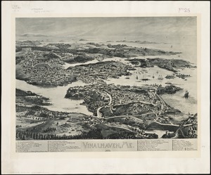
8127.
Vinalhaven, Me : 1893
8128.
Vineyard Haven, Dukes County, Martha's Vineyard, Massachusetts : the popular seaside summer resort
8129.
Vineyard Sound and Buzzards Bay, Massachusetts
8130.
Virginia
8131.
Virginia
8132.
Virginia
8133.
Virginia and Maryland
8134.
Virginia, Maryland, Pennsilvania, east & west New Jarsey
8135.
Virginia Marylandia et Carolina in America septentrionali Brittannorum industria excultæ
8136.
Virginiae item et Floridae Americae provincarum, nova descriptio
8137.
Virginiae item et Floridae Americae provinciarum, nova descriptio
8138.
Virginiae partis australis et Floridae partis orientalis, interjacentium[que] regionum nova descriptio
8139.
Virginiae partis australis, et Floridae partis orientalis, interjacentiumq[ue] regionum nova descriptio
8140.
A vision of Private Kutschkes of the German National Guard = Traumgebild des deutschen Landwehrmanns Kutschke!
8141.
Vltoniae orientalis : pars
8142.
Vmbria overo ducato di Spoleto
8143.
Völker und sprachen-karte von Deutschland und den nachbarländern im j. 1867
8144.
Volunteer militia and eastern army guide : One hundred and fifty miles around Richmond
8145.
Vom Rhein bis Paris
8146.
Vorstellung einiger Gegenden und Plaetze in Nord-America unter Franzoesisch und Englische Jurisdiction gehoerig
8147.
Vtriusque Castellae nova descriptio
8148.
La vue a vol d'oiseau de l'Abbaye de Saint-Martin de Laon (de l'Ordre de Prémontré)
8149.
Vue de Quebec, capitale du Canada
8150.
Vue du Port-au-Prince et ses environs
8151.
W. & A.K. Johnston's map to illustrate the Chinese question
8152.
W. & A.K. Johnston's maps to illustrate the Niger and Upper Nile questions
8153.
Wage map no. 1 - Polk Street to Twelfth, Halsted Street to Jefferson, Chicago ; Wage map no. 2 - Polk Street to Twelfth,...
8154.
Wage map no. 3 - Polk Street to Twelfth, Beach Street to Pacific Avenue, Chicago ; Wage map no. 4 - Polk Street to Twelfth,...
8155.
Wahre Bildtnüé der vesten Statt Montavban und wie dieselbe von Königl. Maÿ. in Franckreich belägert worden Anno 1621
8156.
Wakefield and Peace Dale, Rhode Island : 1888
8157.
Wakes Island ; Vatoa or Turtle Island and Vuata Vatoa ; Taloo Harbour, Island of Eimeo
8158.
Die Walachei
8159.
Waldoboro, Lincoln County, Maine, 1896
8160.
Wales
8161.
Walling and Gray's map of the United States and territories
8162.
Wallis's plan of the cities of London & Westminster
8163.
Wallis's tour through the United Kingdom of England, Scotland and Ireland, a new geographical game, comprehending all the...
8164.
Wallowa National Forest, Oregon
8165.
Walpole, Massachusetts : 1882
8166.
Waltham, 1911
8167.
Walworth County, Wis.
8168.
War chart of the Southern States showing the towns, rivers, rail-roads and common roads
8169.
War map no. 2 : northern Italy
8170.
War map of Central Europe from Paris to Vienna
8171.
War map of the Rhine frontiers
8172.
War maps and diagrams
8173.
War maps of Cuba, Porto Rico, and the Philippines
8174.
War telegram marking map
8175.
Ward 1 [of Boston]
8176.
Ward boundaries 1959
8177.
Ward lines and voting precincts 1954
8178.
Ward lines and voting precincts circa 1945
8179.
Warner, N.H : 1887
8180.
Warren
8181.
Warren, Rhode Island
8182.
Warren, Worcester County, Massachusetts, November 1911 : including West Warren
8183.
Warwicum, Northamtonia, Huntingdonia, Cantabrigia, Suffolcia, Oxonium, Buckinghamia, Bedfordia, Hartfordia, Essexia, Berceria,...
8184.
Washakie National Forest, Wyoming
8185.
Washington
8186.
Washington & its vicinity
8187.
Washington & Ozaukee Counties, Wis.
8188.
Washington and Marion counties
8189.
Washington and vicinity
8190.
Washington, Rhode Island : 1888
8191.
Washington Sound and approaches, Washington Territory, 1866
8192.
Washington Street boulevard study : generalized land use - proposed
8193.
Washington Street boulevard study : proposed fabric
8194.
Washington Street boulevard study : corridor wide urban design strategy
8195.
Washington Street corridor : South Cove to Forest Hills
8196.
Washington Territory
8197.
Wastewater system map, Boston proper, sheet no. 23h
8198.
Water shed of the Passaic River
8199.
Waterfront skyline
8200.
Waupaca County, Wis.
‹ Prev
Next ›
1
2
…
78
79
80
81
82
83
84