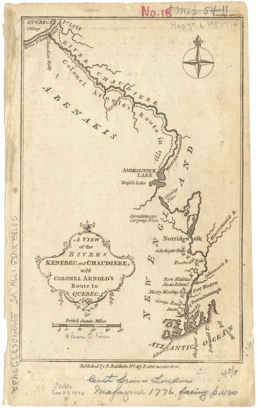
A view of the Rivers Kenebec and Chaudiere, with Colonel Arnold's route to Quebec
This map is also available in American Revolutionary Geographies Online (ARGO), a collections portal especially built for material relating to the American Revolutionary War Era. Visit ARGO to learn more about this item and explore the historical geography of North America in the late eighteenth century.
Item Information
- Title:
- A view of the Rivers Kenebec and Chaudiere, with Colonel Arnold's route to Quebec
- Date:
-
1776
- Format:
-
Maps/Atlases
- Location:
-
Boston Public Library
Norman B. Leventhal Map & Education Center - Collection (local):
-
Norman B. Leventhal Map & Education Center Collection
- Subjects:
-
Kennebec River (Me.)--History--18th century--Maps--Early works to 1800
Chaudière River (Québec)--History--Revolution, 1775-1783--Maps--Early works to 1800
- Places:
-
MaineKennebec (river)
CanadaQuebec (province)Chaudière, Rivière (river)
- Extent:
- 1 map ; 18 x 12 cm.
- Terms of Use:
-
No known copyright restrictions.
No known restrictions on use.
- Publisher:
-
London :
R. Baldwin
- Scale:
-
Scale [ca. 1:2,325,000].
- Language:
-
English
- Notes:
-
From London Magazine 45 (1776): opp. 480.
- Identifier:
-
06_01_003216
- Call #:
-
G3732.K4S3 1776 .V5
- Barcode:
-
39999058999432


