Toggle navigation
LMEC Home
Exhibitions
Georeferencing
Tools for Teachers
Collections
My Favorites
Sign Up / Log In
Search
Search the map portal
Map Collection
Map Collection
Map Sets
Search
Search
Search for
Search In
All Fields
Creator
Title
Subject
Place
Search All Digital Collections
Advanced Search
8182 Results
My Search
Start Over
More Like
commonwealth:6h446x056
Remove constraint More Like: commonwealth:6h446x056
Filter your Search
Place
North and Central America
4,931
United States
3,620
Suffolk (county)
1,044
Boston
1,017
Europe
963
Canada
427
France
269
Massachusetts
250
more
Place
»
Topic
Boston (Mass.)--Maps
575
United States--Maps
270
Real property--Massachusetts--Boston--Maps
180
Massachusetts--Maps
161
Landowners--Massachusetts--Boston--Maps
138
North America--Maps--Early works to 1800
103
New England--Maps
99
Europe--Maps
78
more
Topic
»
Date
Date range begin
–
Date range end
Current results range from
1482
to
2023
View distribution
Creator
United States. Hydrographic Office
357
O.H. Bailey & Co
148
Des Barres, Joseph F. W. (Joseph Frederick Wallet), 1722-1824
123
United States. Post Office Dept
120
Ptolemy, 2nd cent
100
Walling, Henry Francis, 1825-1888
94
Jefferys, Thomas, -1771
84
Geological Survey (U.S.)
83
more
Creator
»
Format
Maps/Atlases
8,123
Manuscripts
215
Prints
51
Books
36
Objects/Artifacts
10
Drawings/Illustrations
8
Posters
4
Georeferenced
Yes
870
No
7,312
Collection
Norman B. Leventhal Map Center Collection
8,163
Boston and New England Maps
2,196
Urban Maps
1,937
Maritime Charts and Atlases
750
American Revolutionary War-Era Maps
616
Boston Redevelopment Authority Collection
98
Massachusetts Real Estate Atlases
7
Available to use
No known restrictions
8,034
Creative Commons license
46
Search Constraints
Sort by relevance
relevance
title
date (asc)
date (desc)
Number of results to display per page
100 per page
10
per page
20
per page
50
per page
100
per page
View results as:
grid view
map view
Search Results
1.
Atlas of Dorchester, West Roxbury and Brighton, city of Boston
2.
Atlas of the city of Boston : volume 6 : West Roxbury : from actual surveys and official plans
3.
Atlas of the city of Boston : volume 6 : West Roxbury : from actual surveys and official plans
4.
Atlas of the city of Boston : West Roxbury : from actual surveys and official plans
5.
Atlas of the city of Boston : West Roxbury : from actual surveys and official plans
6.
Atlas of the city of Boston : West Roxbury : volume five : from actual surveys and official records
7.
Atlas of the city of Boston, West Roxbury, Mass., volume six : from actual surveys and official plans
8.
Atlas of the county of Suffolk, Massachusetts : vol. 5th, West Roxbury, now ward 17, Boston : from actual survey & official...
9.
Plan of Bradford Estate, Roslindale, Ward 23, Boston
10.
Map of Dorchester, Roxbury, and West Roxbury
11.
Map of the town of Roxbury : surveyed by order of the town authorities
12.
Map of West Roxbury
13.
Plan no. 1 of building lots near Spring St. Station West Roxbury belonging to the West Roxbury Land Co
14.
Plan of dwelling houses & house lots, in West Roxbury
15.
Plan of house lots, Mt. Vernon St., West Roxbury : owned by the Mt. Vernon Land Company, 257 Washington St., Room 3
16.
Plan of lands in West-Roxbury, belonging to the estate of Chas. M. Taft : to be sold by public auction on Wednesday June 9th...
17.
Plan of lands in West-Roxbury, belonging to the estate of Chas. M. Taft : to be sold by public auction in Wednesday June 9th at...
18.
Plan of Mount Hope Cemetery : including the City Cemetery belonging to the City of Boston and situated in West Roxbury &...
19.
Plan of the town of West Roxbury : compiled from various plans and surveys, by order of the selectmen
20.
Trustees' sale : beautiful building lots on Walnut St. and Walnut Avenue, in West Roxbury, containing about 3,126,519 square feet
21.
West Roxbury Park : West Roxbury district
22.
Atlas of the city of Boston : Roxbury : from actual surveys and official plans
23.
Atlas of the city of Boston : Roxbury : from actual surveys and official plans
24.
Atlas of the city of Boston : Roxbury : from actual surveys and official plans
25.
Atlas of the city of Boston : Roxbury : from actual surveys and official plans
26.
Atlas of the city of Boston : Roxbury : volume two : from actual surveys and official records
27.
Atlas of the city of Boston : Roxbury, Mass. : volume three : from actual surveys and official records
28.
Atlas of the county of Suffolk, Massachusetts : vol. 2nd late city of Roxbury, now wards 13-14 and 15, city of Boston
29.
Chart of Jamaica Pond and plan of surroundings
30.
Forest Hills Cemetery : consecrated June 28th, 1848 : area 203 acres
31.
Jamaica Park and Bussey Farm Parkway : West Roxbury district
32.
Jamaica Plain view of the world
33.
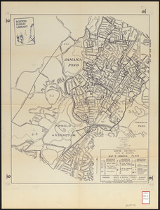
Jamaica Pond master plan
34.
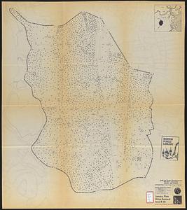
Map of Arnold Arboretum showing location of the trees and shrubs
35.
Map of Arnold Arboretum showing location of the trees and shrubs
36.
Map of proposed arboretum, showing its outlines and local connections, with a study for public drive passing through it
37.
Olmsted Park master plan
38.
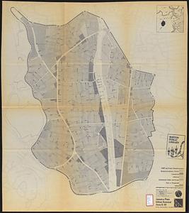
Plan of the Arnold Arboretum Jamaica Plain Mass
39.
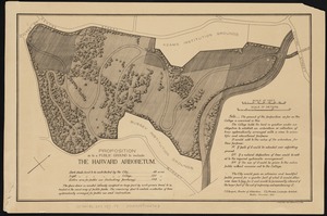
Proposition as to a public ground to include the Harvard Arboretum
40.
Washington Street corridor : South Cove to Forest Hills
41.
Atlas of Dorchester, West Roxbury, and Brighton, City of Boston
42.
Atlas of Massachusetts
43.
Atlas of the city of Boston : West Roxbury
44.
Atlas of the city of Boston : vol. 5, West Roxbury
45.
Atlas of the city of Boston : volume 6, West Roxbury
46.
Atlas of the city of Boston : West Roxbury
47.
Atlas of the county of Suffolk, Massachusetts, vol. 5 : West Roxbury, now ward 17, Boston
48.
Hancock Woods : as of right plan
49.
Hancock Woods EGA
50.
Adams Nervine Asylum
51.
Jamaica Plain urban renewal area r-49 : building conditions
52.
Jamaica Plain urban renewal area r-49 : existing population density
53.
Jamaica Plain urban renewal area r-49 : existing and proposed community facilities
54.
Jamaica Plain urban renewal area r-49 : proposed land use
55.
Jamaica Plain urban renewal area r-49 : existing land use
56.
Jamaica Plain urban renewal area r-49 : proposed circulation
57.
Jamaica Plain urban renewal area r-49 : existing circulation
58.
Jamaica Plain urban renewal area r-49 : proposed treatment and title I projects
59.
Zoning districts city of Boston map 9 Jamaica Plain
60.
The 100th anniversary map of Abraham Lincoln's visit to Massachusetts, September 11-23, 1848
61.
1630 shoreline
62.
1879. Progress map of the U.S. Geographical Surveys west of the 100th Meridian : prepared under the direction of 1st Lieut....
63.
1903 Map of Salem and surrounding places
64.
19th annual convention of the National Association of Real Estate Boards : at Tulsa, June 7 to June 11 in 1926
65.
2005 significant U.S. hurricane strikes
66.
The 2100 project : an atlas for the Green New Deal
67.
227 Harzgerode
68.
305 Glatz
69.
38,000,000 escaped -- 10,000,000 died
70.
4 Kinten
71.
660 Wakulah St., Roxbury
72.
[A chart of Boston Bay and vicinity]
73.
[A chart of New York Island & North River : East River, passage through Hell Gate, Flushing Bay, Hampstead Bay, Oyster,...
74.
The A.A.A. key road map of continental Europe
75.
Aaron Bohrod's America, its history
76.
ABC pathfinder railway guide map : eastern division
77.
Abolition of Slavery, 1863
78.
Aboriginal map of North America, denoting the boundaries and the locations of various Indian tribes
79.
Acapulco, México
80.
Accurata delineatio Castrorum Suecicorum, ut et Haffniae, Regni Daniae Metropolis
81.
Accurata delineatio oppugnatae a faederatis, Caesareis, Polonicis, Danicis, et Brandeburgicis copijs sub-ductu Seren: Electoris...
82.
Accurata delineatio regionis circa Nieburgum Fioniæ cum prælio ibi commisso inter Danorum et fæderatorum exercitum ab una et...
83.
Accurata Scaniae, Blekingiae et Hallandiae descriptio
84.
An accurate map of Cuba, and the adjacent islands
85.
An accurate map of Dorset Shire divided into hundreds
86.
An accurate map of Dorset Shire, divided into its hundreds
87.
An accurate map of England and Wales with the principal roads from the best authorities
88.
An accurate map of England and Wales with the principal roads from the best authorities
89.
An accurate map of Europe from the best authorities
90.
An accurate map of Hindostan or India, from the best authorities
91.
An accurate map of His Majesty's province of New-Hampshire in New England : taken from actual surveys of all the inhabited...
92.
An Accurate map of New Hampshire in New England, from a late survey
93.
An Accurate map of New York in North America, from a late survey
94.
An accurate map of North America : describing and distinguishing the British and Spanish dominions on this great continent :...
95.
An accurate map of North America : describing and distinguishing the British and Spanish dominions of this great continent;...
96.
An accurate map of North America : describing and distinguishing the British, Spanish and French dominions on this great...
97.
An accurate map of North and South Carolina with their Indian frontiers, shewing in a distinct manner all the mountains,...
98.
An accurate map of Rhode Island, part of Connecticut and Massachusets, shewing Admiral Arbuthnot's station in blocking up...
99.
An accurate map of the coast of Cape de Verde
100.
An accurate map of the Commonwealth of Massachusetts exclusive of the district of Maine : compiled pursuant to an Act of the...
‹ Prev
Next ›
1
2
3
4
5
…
81
82


![[A chart of Boston Bay and vicinity]](https://bpldcassets.blob.core.windows.net/derivatives/images/commonwealth:cj82m2976/image_thumbnail_300.jpg)


