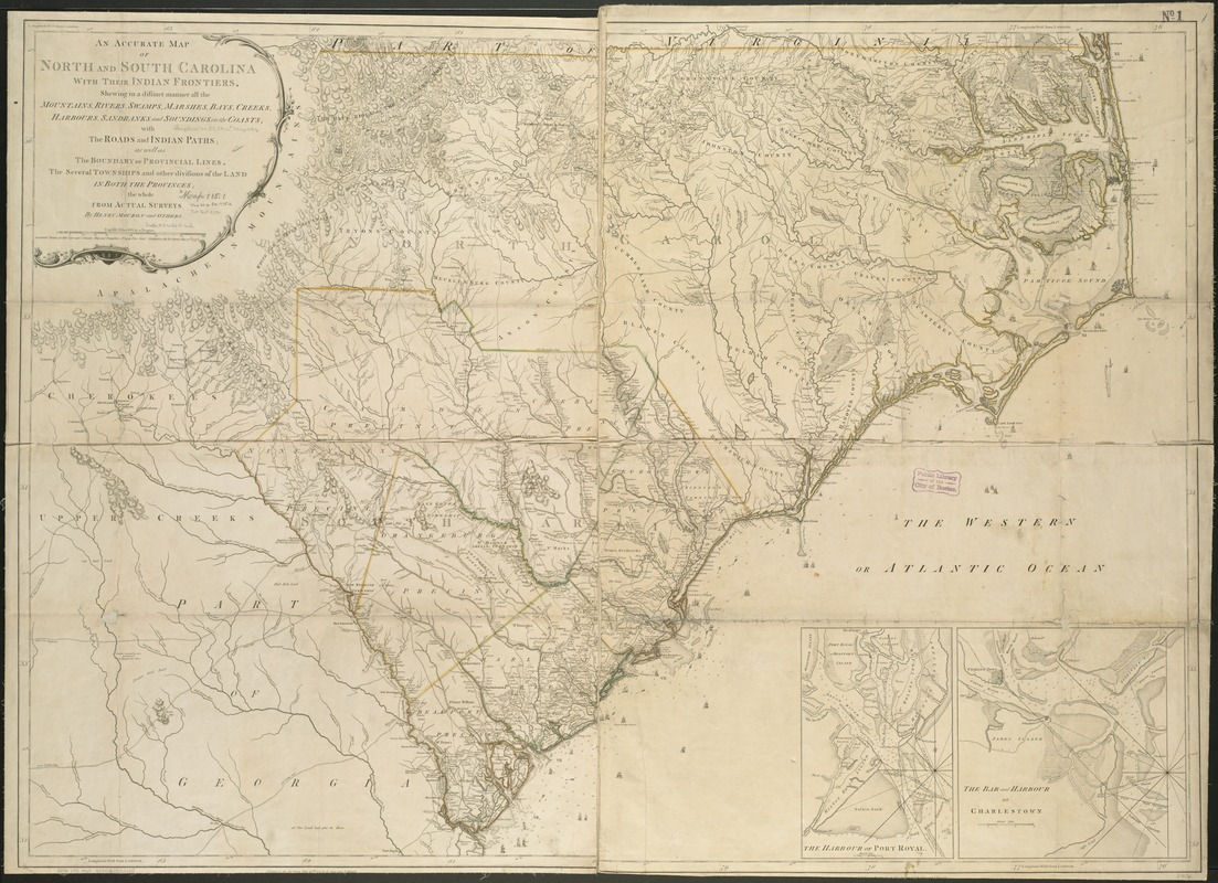
An accurate map of North and South Carolina with their Indian frontiers, shewing in a distinct manner all the mountains, rivers, swamps, marshes, bays, creeks, harbours, sandbanks and soundings on the coasts : with the roads and Indian paths : as well as the boundary of provincial lines, the several townships and other divisions of the land in both the provinces
This map is also available in American Revolutionary Geographies Online (ARGO), a collections portal especially built for material relating to the American Revolutionary War Era. Visit ARGO to learn more about this item and explore the historical geography of North America in the late eighteenth century.
Item Information
- Title:
- An accurate map of North and South Carolina with their Indian frontiers, shewing in a distinct manner all the mountains, rivers, swamps, marshes, bays, creeks, harbours, sandbanks and soundings on the coasts : with the roads and Indian paths : as well as the boundary of provincial lines, the several townships and other divisions of the land in both the provinces
- Creator:
- Mouzon, Henry.
- Name on Item:
-
the whole from actual surveys by Henry Mouzon and others.
- Date:
-
1775
- Format:
-
Maps/Atlases
- Location:
-
Boston Public Library
Norman B. Leventhal Map & Education Center - Collection (local):
-
Norman B. Leventhal Map & Education Center Collection
- Subjects:
-
Harbors--South Carolina--Charleston--Maps--Early works to 1800
Harbors--South Carolina--Beaufort--Maps--Early works to 1800
North Carolina--Maps--Early works to 1800
South Carolina--Maps--Early works to 1800
North Carolina--Administrative and political divisions--Maps--Early works to 1800
South Carolina--Administrative and political divisions--Maps--Early works to 1800
- Places:
-
North Carolina
South CarolinaBeaufort (county)Beaufort
South CarolinaCharleston (county)Charleston
- Extent:
- 1 map : col. ; 100 x 137 cm.
- Terms of Use:
-
No known copyright restrictions.
No known restrictions on use.
- Publisher:
-
London :
Printed for Robt. Sayer and J. Bennett
- Scale:
-
Scale ca. 1:530,000.
- Language:
-
English
- Notes:
-
Relief shown by hachures. Depths shown by soundings.
"Longitude west from London."
Shows precinct boundaries.
Insets: The harbour of Port Royal [ca. 1:200,000]--The bar and harbour of Charlestown [ca. 1:75,000].
- Identifier:
-
06_01_006287
- Call #:
-
G3900 1775 .M68
- Barcode:
-
39999059022135


