Toggle navigation
LMEC Home
Exhibitions
Georeferencing
Tools for Teachers
Collections
My Favorites
Sign Up / Log In
Search
Search the map portal
Map Collection
Map Collection
Map Sets
Search
Search
Search for
Search In
All Fields
Creator
Title
Subject
Place
Search All Digital Collections
Advanced Search
13694 Results
Filter your Search
Place
North and Central America
10,357
United States
8,484
Massachusetts
2,796
Suffolk (county)
1,678
Boston
1,634
Europe
1,419
Canada
950
New York
650
more
Place
»
Topic
Boston (Mass.)--Maps
748
City planning--Massachusetts--Boston--Maps
418
United States--History--Revolution, 1775-1783--Maps
329
United States--Maps
322
Real property--Massachusetts--Boston--Maps
254
Urban renewal--Massachusetts--Boston--Maps
254
Massachusetts--Maps
233
Insurance surveys
197
more
Topic
»
Date
Date range begin
–
Date range end
Current results range from
1482
to
2023
View distribution
Creator
United States. Hydrographic Office
597
Boston Redevelopment Authority
404
Des Barres, Joseph F. W. (Joseph Frederick Wallet), 1722-1824
247
Royal United Services Institute for Defence and Security Studies
160
Jefferys, Thomas, -1771
154
George, III, King of Great Britain, 1738-1820
152
George, IV, King of Great Britain, 1762-1830
151
O.H. Bailey & Co
148
more
Creator
»
Format
Maps/Atlases
13,513
Manuscripts
985
Prints
102
Books
49
Drawings/Illustrations
44
Photographs
15
Objects/Artifacts
13
Documents
7
more
Format
»
Georeferenced
Yes
979
No
12,715
Collection
Norman B. Leventhal Map & Education Center Collection
9,108
American Revolutionary War-Era Maps
3,305
Boston and New England Maps
2,921
Urban Maps
2,480
Maritime Charts and Atlases
1,169
William L. Clements Library Collection
910
Library of Congress Collection
618
Boston Redevelopment Authority Collection
475
more
Collection
»
Available to use
No known restrictions
10,260
Creative Commons license
1,678
Search Constraints
Sort by date (desc)
relevance
title
date (asc)
date (desc)
Number of results to display per page
50 per page
10
per page
20
per page
50
per page
100
per page
View results as:
grid view
map view
Search Results
1.
Barton Street, West End
2.
Boston's top 5 immigrant populations
3.
East Boston flood risk
4.
Fairbanks Street, Brighton
5.
How we get around today
6.
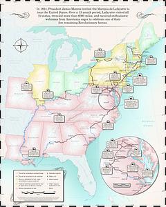
Map of the Marquis de Lafayette's 1824-1825 tour of the United States
7.
Oxford Street, Chinatown
8.
A city of unequal risks
9.
A people's map of Lawrence, Massachusetts
10.
A shared problem, an unequal burden : causes & consequences of climate change
11.
Tax parcels that would have been underwater in 1630
12.
Boston kids count
13.
Change in median housing value, 2010 to 2018
14.
Change in white population (non-Hispanic), 2010 to 2018
15.
Disconnected : Boston's free wi-fi leaves many in the dark
16.
The great transit desert
17.
Health crisis : Massachusetts' low income families more likely to live near hazardous sites
18.
Health success : Massachusetts well-prepared to deal with health issues from hazardous sites
19.
A hexagonal chart of yearly snowfall in New England up through and including November 1, 2020
20.
Hotbeds of contamination : the toxicity of our cities
21.
Jamaica Plain view of the world
22.
Map of public transportation routes in Greater Boston served by the Massachusetts Bay Transportation Authority comprising 64...
23.
Mean travel time to work
24.
Most popular mode of commuting : 2014-2018 American Community Survey
25.
Percent foreign-born
26.
Plenty of free wi-fi is keeping Boston connected!
27.
Proportion of units where rent costs over 30% of resident's income
28.
Rethinking hazardous beliefs : challenging perceptions of the "dirty city"
29.
Suburban Boston teachers are the highest earners
30.
Suburban Boston teachers are the lowest earners
31.
Total foreign-born
32.
A type-ology of population in Massachusetts
33.
United States bee colonies
34.
Western Massachusetts closed to the public
35.
Western Massachusetts open space abounds
36.
The 2100 project : an atlas for the Green New Deal
37.
Boston Public Library
38.
Boston's neighborhoods by percentage of foreign-born (by census tract)
39.
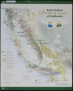
National rivers & trails of California
40.
Back Bay view of the world
41.
Boston neighborhoods : top 10 countries of birth for foreign-born population
42.
Boston's top 5 foreign languages spoken at home, 2015
43.
Boston's top foreign-born populations : Cape Verdeans
44.
Boston's top foreign-born populations : Vietnamese
45.
Boston's top foreign-born populations : Dominicans
46.
Boston's top foreign-born populations : Haitians
47.
Boston's top foreign-born populations : Chinese
48.
Boston's top foreign-born populations : Salvadorans
49.
Open space 2017
50.
Boston distance to the nearest supermarket
‹ Prev
Next ›
1
2
3
4
5
…
273
274