Boston's top 5 immigrant populations

Item Information
- Title:
- Boston's top 5 immigrant populations
- Cartographer:
- Coughlin, Thomas G.
- Publisher:
- Boston Public Library. Norman B. Leventhal Map and Education Center
- Name on Item:
-
graphic: Thomas Coughlin
- Date:
-
2023
- Format:
-
Maps/Atlases
- Genre:
-
Diagrams
- Location:
-
Boston Public Library
Norman B. Leventhal Map & Education Center - Collection (local):
-
Norman B. Leventhal Map & Education Center Collection
- Subjects:
-
Boston (Mass.)--Maps
Immigrants--Massachusetts--Boston--Maps
- Places:
-
MassachusettsSuffolk (county)Boston
- Extent:
- 5 maps : color
- Terms of Use:
-
Under copyright.
This work is licensed for use under a Creative Commons Attribution License (CC BY).

- Publisher:
-
[Boston] :
Norman B. Leventhal Map & Education Center at the Boston Public Library
- Language:
-
English
- Table of Contents:
-
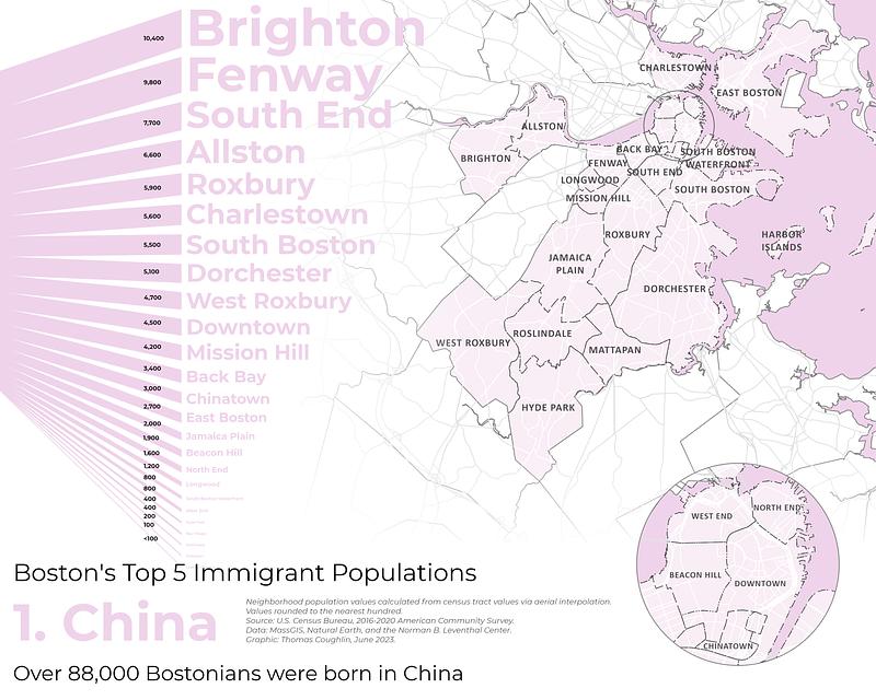
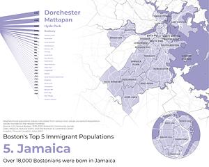
1. China
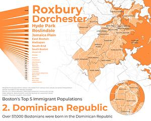
2. Dominican Republic
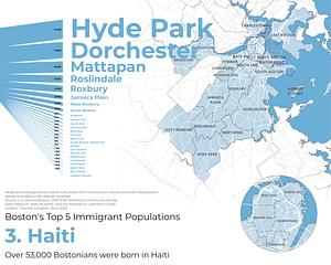
3. Haiti
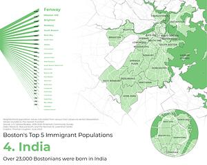
4. India
5. Jamaica
- Notes:
-
Diagrams show approximate number of immigrants by neighborhood, based on the 2016-2020 American Community Survey.
Created for the Norman B. Leventhal Map & Education Center cartography challenge "No Choropleth, No Problem: Visualizing Immigration in Greater Boston."
- Identifier:
-
China2
DominicanRepublic
Haiti
India
Jamaica


