How we get around today
Item Information
- Title:
- How we get around today
- Description:
-
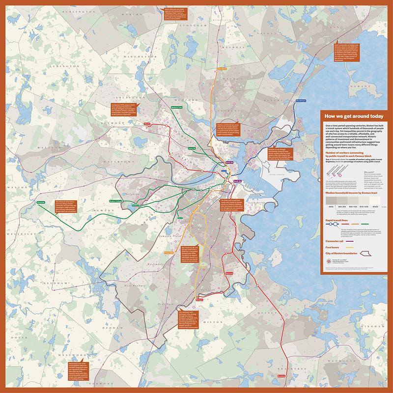
Over a time period spanning centuries, Boston has built a transit system which hundreds of thousands of people use each day. Yet inequalities persist in the geography of who has access to a reliable, affordable, and well-connected transportation network. Historic patterns of investment and disinvestment in communities and transit infrastructure suggest how getting around town means many different things depending on where you live.
- Cartographer:
- Nelson, Garrett Dash
- Publisher:
- Boston Public Library. Norman B. Leventhal Map and Education Center
- Name on Item:
-
cartography and analysis: Garrett Dash Nelson, Leventhal Map & Education Center
- Date:
-
2023
- Format:
-
Maps/Atlases
- Location:
-
Boston Public Library
Norman B. Leventhal Map & Education Center - Collection (local):
-
Norman B. Leventhal Map & Education Center Collection
- Subjects:
-
Boston Metropolitan Area (Mass.)--Maps
Local transit--Massachusetts--Boston Metropolitan Area--Maps
Commuters--Massachusetts--Boston Metropolitan Area--Maps
Income--Massachusetts--Boston Metropolitan Area--Maps
- Places:
-
MassachusettsSuffolk (county)Boston
- Extent:
- 1 map : color
- Terms of Use:
-
Under copyright.
This work is licensed for use under a Creative Commons Attribution License (CC BY).

- Publisher:
-
[Boston] :
Norman B. Leventhal Map & Education Center at the Boston Public Library
- Language:
-
English
- Notes:
-
Shows rapid transit lines, commuter rail, free buses, number of workers commuting by public transit in each census block, percentage of workers commuting by public transit in each census block, median household income by census tract, and average number of weekday gated entries at rapid transit stations in fiscal year 2019.
Includes notes.
- Notes (exhibitions):
-
Exhibited: "Getting around town: four centuries of mapping Boston in transit," Norman B. Leventhal Map & Education Center at the Boston Public Library, 2023-2024.
- Identifier:
-
GAT_FloorMap


![Boston personal income ; Boston personal income [and] residential population density](https://bpldcassets.blob.core.windows.net/derivatives/images/commonwealth:fn107c409/image_thumbnail_300.jpg)


