Toggle navigation
LMEC Home
Exhibitions
Georeferencing
Tools for Teachers
Collections
My Favorites
Sign Up / Log In
Search
Search the map portal
Map Collection
Map Collection
Map Sets
Search
Search
Search for
Search In
All Fields
Creator
Title
Subject
Place
Search All Digital Collections
Advanced Search
8650 Results
My Search
Start Over
More Like
commonwealth:wd376294q
Remove constraint More Like: commonwealth:wd376294q
Filter your Search
Place
North and Central America
5,936
United States
4,849
Massachusetts
2,108
Europe
1,359
Suffolk (county)
1,035
Boston
1,008
Canada
462
Asia
422
more
Place
»
Topic
Boston (Mass.)--Maps
580
United States--Maps
314
Massachusetts--Maps
218
Real property--Massachusetts--Boston--Maps
174
Landowners--Massachusetts--Boston--Maps
132
North America--Maps--Early works to 1800
103
New England--Maps
100
Europe--Maps
78
more
Topic
»
Date
Date range begin
–
Date range end
Current results range from
1482
to
2023
View distribution
Creator
United States. Hydrographic Office
594
O.H. Bailey & Co
148
Des Barres, Joseph F. W. (Joseph Frederick Wallet), 1722-1824
123
United States. Post Office Dept
120
Ptolemy, 2nd cent
100
Walling, Henry Francis, 1825-1888
95
Geological Survey (U.S.)
93
Jefferys, Thomas, -1771
85
more
Creator
»
Format
Maps/Atlases
8,590
Manuscripts
217
Prints
56
Books
36
Objects/Artifacts
10
Drawings/Illustrations
8
Posters
4
Ephemera
1
Georeferenced
Yes
881
No
7,769
Collection
Norman B. Leventhal Map & Education Center Collection
8,583
Boston and New England Maps
2,237
Urban Maps
1,937
Maritime Charts and Atlases
1,081
American Revolutionary War-Era Maps
669
Boston Redevelopment Authority Collection
90
American Antiquarian Society Collection
24
William L. Clements Library Collection
21
more
Collection
»
Available to use
No known restrictions
8,440
Creative Commons license
53
Search Constraints
Sort by date (asc)
relevance
title
date (asc)
date (desc)
Number of results to display per page
100 per page
10
per page
20
per page
50
per page
100
per page
View results as:
grid view
map view
Search Results
8101.
Woman suffrage, 1900
8102.
Woman suffrage, 1915
8103.
Woman suffrage, 1920
8104.
Atlas of the city of Boston : Dorchester : from actual surveys and official plans
8105.
Capital Park : Hyde Park ... Boston
8106.
A chart of the coast of Maine
8107.
In flight with United Air Lines
8108.
Manhattan : first city of America
8109.
A map of Chicago : incorporated as a town August 5, 1833
8110.
A map of Long Island
8111.
Mount Hope Bridge, Bristol, Rhode Island
8112.
Siskiyou National Forest, Oregon and California
8113.
Siuslaw National Forest, Oregon
8114.
Tennessee River basin
8115.
The topographic map of Manchoukuo
8116.
Being a cartograph of Ohio : the oldest state west of the thirteen original colonies; now the fourth state in the Union in...
8117.
City of Melrose assessors plans
8118.
Financial irrigation of the United States by funds appropriated for emergency use under the New Deal
8119.
Map of Boston Common : with surrounding streets & adjacent parts of Beacon Hill
8120.
Republican mid-summer outing and Massachusetts Bay Cruise to Provincetown Saturday, August 4, 1934
8121.
Teton National Forest, Wyoming
8122.
The townships of Dedham, Westwood, Needham, Dover, Sherborn, Norwood, Medfield, Millis, Walpole, Norfolk, Massachusetts
8123.
Umpqua National Forest, Oregon
8124.
Wereldkaart "reis om de wereld"
8125.
Whitman National Forest, Blue Mountains Division, Oregon
8126.
Whitman National Forest, Minam Division, Oregon
8127.
Asia, ca. 100 A.D.
8128.
Asia under the Mongols, 1290 A.D.
8129.
Atlas town of Wellesley
8130.
The beginnings of ancient China, 1900-1300 B.C.
8131.
Boston, Massachusetts
8132.
A canoeist's guide to New England's rivers
8133.
China's situation in the world
8134.
The contending states - boundaries of 350 B.C.
8135.
The country of So red the rose, by Stark Young, Scribners
8136.
Eastern, Central and Southern Asia, 1760 A.D.
8137.
Europe in search of new routes to India and China, 1486-1616 A.D.
8138.
Foreign religions in Central Asia and China up to the 14th century A.D.
8139.
France
8140.
[Illustrated historical map of Shanghai]
8141.
Italy
8142.
The land of make believe
8143.
The Manchu Empire and the European powers, 1644-1912, A.D.
8144.
Map of the city of Providence, Rhode Island
8145.
Modern Tibet (Hsi-K'Ang and Hsi-Tsang) - Political and Economic
8146.
The oil and gas journal, August 29, 1935
8147.
Philips Radio
8148.
Physical geography with the boundaries of ancient China
8149.
A pictorial map of Germany
8150.
A pictorial map of Germany
8151.
A pictorial map of the British Isles
8152.
P.W.A. in action
8153.
Racing routes of the Yankee clippers
8154.
Route and pictorial map of Maine
8155.
This map presents a Bostonian's idea of the United States of America
8156.
Transportation map of Manchoukuo
8157.
The United States of America
8158.
Van Loon's map of the United States : enlivened by thumbnail sketches of American history
8159.
Wallowa National Forest, Oregon
8160.
America : beauty, wonders, inspiration, progress, without end
8161.
Boston Elevated Railway system map
8162.
A New Yorker's idea of the United States of America
8163.
Olde York County Maine : published in commemoration of the 300th anniversary
8164.
Property atlas of city of Lowell, northern district, Middlesex County, Massachusetts, showing the entire city complete in one...
8165.
Winter sports map of the Berkshire Hills
8166.
Boston Elevated Railway system route map
8167.
Cape Cod, Barnstable County, Mass.
8168.
Civil airways of the United States as designated in Civil Air Regulations - chapter 60
8169.
Frontier, Montana, pioneer : a one page history dedicated to the Old Timers
8170.
The White Mountains of New Hampshire
8171.
Atlas of the city of Boston : Boston proper and Back Bay : from actual surveys and official plans
8172.
Boston Elevated Railway system route map
8173.
Boston (Massachusetts) and vicinity : a pictorial map
8174.
Boston (Massachusetts) and vicinity : a pictorial map
8175.
Boston (Massachusetts) and vicinity : a pictorial map
8176.
Carriers of the new black plague
8177.
Downtown district of Manhattan
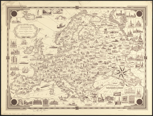
8178.
Europe : a pictorial map
8179.
Index map of watersheds showing sanitary districts and bacteriological sampling stations
8180.
Lake Champlain streamline ferries : direct routes to Whiteface Mtn., Ausable Chasm, scenic short-cuts between Green Mountains,...
8181.
Midsummer's marvels
8182.
North Atlantic Ocean, Bermuda Islands : from British surveys to 1926, with additions and corrections to 1936
8183.
Now see America by Grace Line
8184.
Limited edition, 500 only of a pictorial map covering the New England States U.S.A
8185.
Map of Scituate Rhode Island
8186.
Pictorial map of Mexico
8187.
A pictorial map of that portion of New York City known as Manhattan, also showing parts of the Bronx
8188.
A pictorial map of the British Isles
8189.
A pictorial map of the New England states U.S.A.
8190.
PWA rebuilds the nation
8191.
Shall Union Square overshadow the United States? : America's other 60 families : the real rulers of America
8192.
World wonders : a pictorial map
8193.
38,000,000 escaped -- 10,000,000 died
8194.
America the wonderland : a pictorial map of the United States
8195.
Art forms of the Pacific area
8196.
Boston Elevated Railway system route map
8197.
A map of Cape Cod
8198.
Massachusetts tourists map : showing tourways, picnic sites, beaches, and camp grounds
8199.
Peoples of the Pacific
8200.
P.W.A. and industry : how benefits are spread
‹ Prev
Next ›
1
2
…
78
79
80
81
82
83
84
85
86
87