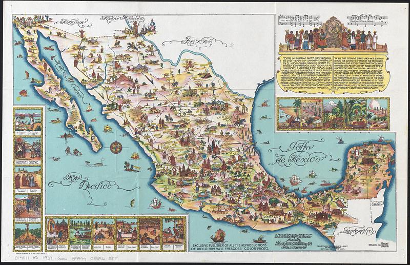
Pictorial map of Mexico
Item Information
- Title:
- Pictorial map of Mexico
- Cartographer:
- Gómez Medina, Miguel
- Publisher:
- Fischgrund Publishing Company
- Name on Item:
-
dibujado por Miguel Gómez Medina
- Date:
-
[ca. 1939]
- Format:
-
Maps/Atlases
- Genre:
-
Pictorial maps
Tourist maps
- Location:
-
Boston Public Library
Norman B. Leventhal Map & Education Center - Collection (local):
-
Norman B. Leventhal Map & Education Center Collection
- Subjects:
-
Mexico--Maps
- Places:
-
Mexico
- Extent:
- 1 map : color ; 32 x 51 cm, folded in envelope 13 x 19 cm
- Terms of Use:
-
No known copyright restrictions.
No known restrictions on use.
- Publisher:
-
Mexico D.F. :
Published by Fischgrund Publishing Co.
- Scale:
-
Not drawn to scale
- Language:
-
English
Spanish
- Notes:
-
Relief and some buildings shown pictorially.
"Exclusive publisher of all the reproductions of Diego Rivera's frescoes color photo."
"Registrado conforme a la ley, no. del reg. 6859, copyrighted in the U.S.A."
Includes illustrations, passage about Mexico from William H. Prescott's historical series "The Nations of the World", and the opening bars of the Mexican national anthem.
"The only pictorial map of the Republic of Mexico by Miguel Gómez Medina showing principal places of interest and everything typical of Mexico. Lithographed in six colors."--Envelope.
- Identifier:
-
06_01_017893
- Call #:
-
G4411.A5 1939 .G66
- Barcode:
-
39999085963179