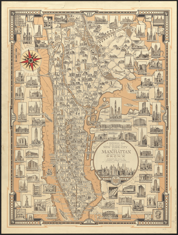
A pictorial map of that portion of New York City known as Manhattan, also showing parts of the Bronx
Item Information
- Title:
- A pictorial map of that portion of New York City known as Manhattan, also showing parts of the Bronx
- Artist:
- Chase, Ernest Dudley, 1878-1966
- Name on Item:
-
designed and drawn by Ernest Dudley Chase of Winchester, Massachusetts
- Date:
-
1939
- Format:
-
Maps/Atlases
- Location:
-
Boston Public Library
Norman B. Leventhal Map & Education Center - Collection (local):
-
Norman B. Leventhal Map & Education Center Collection
- Subjects:
-
Buildings--New York (State)--New York--Pictorial works
Manhattan (New York, N.Y.)--Maps
Bronx (New York, N.Y.)--Maps
- Places:
-
New YorkNew YorkManhattan
New YorkNew YorkBronx
- Extent:
- 1 map : color ; 66 x 48 cm
- Terms of Use:
-
No known copyright restrictions.
No known restrictions on use.
- Publisher:
-
[Winchester, Massachusetts] :
Ernest Dudley Chase
- Scale:
-
Scale approximately 1:38,000
- Language:
-
English
- Notes:
-
Pictorial map.
Oriented with north to the upper left.
Includes illustrations of buildings and structures.
- Identifier:
-
06_01_014774
- Call #:
-
G3804.N4:2M3A5 1939 .C43
- Barcode:
-
39999065705095