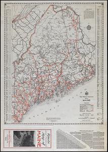
Route and pictorial map of Maine


Item Information
- Title:
- Route and pictorial map of Maine
- Title (alt.):
-
Maine, its recreation and history
State Highway Commission map of Maine
- Publisher:
- Maine. State Highway Commission
- Cartographer:
- Linscott, M.C.
- Date:
-
1935
- Format:
-
Maps/Atlases
- Genre:
-
Pictorial maps
Road maps
- Location:
-
Boston Public Library
Norman B. Leventhal Map & Education Center - Collection (local):
-
Norman B. Leventhal Map & Education Center Collection
- Subjects:
-
Maine--Maps
Roads--Maine--Maps
Recreation--Maine--Maps
- Places:
-
Maine
- Extent:
- 2 maps on 1 sheet : both sides, color ; 65 x 44 cm and 57 x 47 cm, on sheet 72 x 51 cm, folded to 26 x 12 cm
- Terms of Use:
-
No known copyright restrictions.
No known restrictions on use.
- Publisher:
-
[Augusta] :
Maine State Highway Commission
- Scale:
-
Scale not given
Scale approximately 1:840,000
- Language:
-
English
- Table of Contents:
-
Maine, its recreation and history / M.C. Linscott
State Highway Commission map of Maine / Lucius D. Barrows, chief engineer assisted by Frederick P. Bonney.
- Notes:
-
Panel title.
Relief shown pictorially.
Pictorial map includes illustrations, historical notes, 12 inset illustrations, and illustrated border.
Road map includes index to cities and towns and mileage chart.
- Identifier:
-
06_01_018280_A
06_01_018280_B
- Call #:
-
G3731.E63 1935 .M35
- Barcode:
-
39999085965141


