Toggle navigation
LMEC Home
Exhibitions
Georeferencing
Tools for Teachers
Collections
My Favorites
Sign Up / Log In
Search
Search the map portal
Map Collection
Map Collection
Map Sets
Search
Search
Search for
Search In
All Fields
Creator
Title
Subject
Place
Search All Digital Collections
Advanced Search
29 Results
My Search
Start Over
More Like
commonwealth:p8418t59t
Remove constraint More Like: commonwealth:p8418t59t
Filter your Search
Place
United States
27
North and Central America
26
New York
8
Freehold
5
Monmouth (county)
5
Middletown
4
New Jersey
4
Westchester (county)
4
more
Place
»
Topic
United States--History--Revolution, 1775-1783--Maps
7
Landforms--New York (State)--Maps
6
Rivers--New York (State)--Maps
6
Roads--New York (State)--Maps
6
Buildings--New York (State)--Maps
5
Monmouth, Battle of, Freehold, N.J., 1778--Maps
5
Buildings--New York (State)--New York--Maps
4
Landowners--New York (State)--Maps
4
more
Topic
»
Date
Date range begin
–
Date range end
Current results range from
1755
to
1826
View distribution
Creator
Clinton, Henry, Sir, 1738?-1795
3
Erskine, Robert, 1735-1780
3
Faden, William, 1749-1836
3
De Witt, Simeon, 1756-1834
2
Kitchin, Thomas, 1719-1784
2
Robert Sayer and John Bennett (Firm)
2
Barber, J.
1
Bauman, Sebastian
1
more
Creator
»
Format
Maps/Atlases
29
Manuscripts
9
Georeferenced
No
29
Collection
American Revolutionary War-Era Maps
29
New-York Historical Society Collection
24
William L. Clements Library Collection
4
Richard H. Brown Revolutionary War Map Collection at Mount Vernon
1
Available to use
No known restrictions
24
Creative Commons license
1
Search Constraints
Sort by relevance
relevance
title
date (asc)
date (desc)
Number of results to display per page
20 per page
10
per page
20
per page
50
per page
100
per page
View results as:
grid view
map view
Search Results
1.
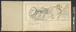
Affaire de Monmouth ce 28me Juin 1778
2.
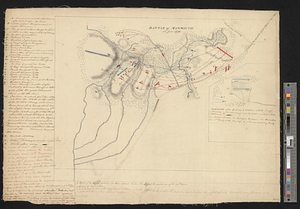
Battle of Monmouth, 28th June 1778
3.
Battle of Monmouth, 28th June 1778
4.
Carte de l'affaire de Montmouth, ou le Général Washington commandon l'armée Americaine, et le Général Clinton l'armée...
5.
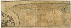
Sketch of part of the road from Freehold to Midde Town shewing the skirmish between the rear of the British army under the...
6.
The Country twenty five miles round New York
7.
Cross Roads to East Chester, and above : no 19
8.
A general map of the middle British colonies, in America : viz Virginia, Màriland, Dèlaware, Pensilvania, New-Jersey, New-York,...
9.
A map of the British and French dominions in North America : with the roads, distances, limits, and extent of the settlements,...
10.
A map of the state of New York
11.
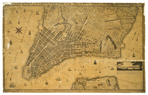
A new & accurate plan of the city of New York in the state of New York in North America
12.
A new and accurate map of the English empire in North America : representing their rightful claim as confirm'd by charters, and...
13.
A new and correct map of North America, with the West India islands, divided according to the preliminary articles of peace,...
14.
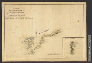
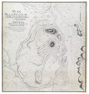
Plan de la position de l'armée sous les ordre de son Excellence le Lieutenant General Bourgoyne à Saratoga etant sur la...
15.
Plan of Niagara with the adjacent country surrendered to the English army under the command of Sr. Willm: Johnson Bart: on the...
16.
A plan of the City of New York from an actual survey anno domini MDCCLV
17.
Plan of the city of New York in North America : surveyed in the years 1766 & 1767
18.
A plan of the entrance of Chesapeak Bay, with James and York Rivers : wherein are shown the respective positions (in the...
19.
A plan of the operations of the King's army under the command of General Sr. William Howe, K.B. in New York and east New...
20.
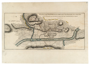
Plan of the position which the army under Lt. Genl. Burgoine took at Saratoga on the 10th of September, 1777, and in which it...
‹ Prev
Next ›
1
2